Incidente vuelo Flybondi

Image result for Flybondi OF 2710

AW | 2018 01 24 05:45 | AVIATION SAFETY

Incidente vuelo FO 2710 de Flybondi Líneas Aéreas

El incidente aéreo ocurrió en el Aeropuerto Internacional Córdoba Ambrosio Taravella, donde el vuelo FO 2710 de Flybondi debía despegar a las 11:00 hs de la mañana. Según los registros del aeropuerto, el avión despegó a las 11:23 hs y el vuelo duró solo 11 minutos.

Desde la aerolínea explicaron que no se trataba de un vuelo inaugural, sino de prueba antes de comenzar a operar los vuelos comerciales. Flybondi comenzará sus operaciones el día viernes desde Córdoba hasta Iguazú.

«El vuelo fue ejecutado con éxito, y en el mismo certificamos la completa aptitud de nuestra aeronave, Nelson, para volar, sin ningún detalle técnico», dijeron. También presentaron un video.

Tras la polémica por el fallido vuelo inaugural con tripulación y familiares, Flybondi emitió un comunicado en las redes sociales en el que volvió a desmentir que hayan tenido inconvenientes y destacaron que una segunda prueba se realizó correctamente. Incluso difundieron el video de su único avión despegando y aterrizando del Aeropuerto de Córdoba.

“Nunca hubo un aterrizaje de emergencia ni tampoco fallas en los motores”, dijo en sus redes sociales la primera línea aérea low cost de Argentina. Así desmienten incluso a su propio piloto quien en un video que se viralizó detalló que “tenía ilusiones de hacer un lindo vuelo pero las circunstancias fueron otras y la seguridad prima. Les pido disculpas por el corto vuelito”.

Para Flybondi ese “fue un inconveniente técnico menor, tratado por nuestro comandante con absoluto profesionalismo. Se siguió el protocolo establecido para estos casos, que garantiza la seguridad de nuestros pasajeros y tripulación. Por esta razón, el vuelo de prueba pautado para tener una duración de 20 minutos, modificó su extensión a 12”.

La línea área que próximamente iniciará operaciones comerciales, informó que este martes “se realizó otro vuelo de prueba para asegurarnos que la falla estuviese solucionada. El vuelo fue ejecutado con éxito, y en el mismo certificamos la completa aptitud de nuestra aeronave, Nelson, para volar, sin ningún detalle técnico”. Junto al comunicado presentaron un video de menos de un minuto con el Boeing 737-800 despegando y aterrizando en el Aeropuerto Ingeniero Aeronáutico Ambrosio Taravella de Cordoba. Este viernes, la empresa tiene previsto realizar su primer vuelo con pasajeros. Será entre Córdoba y Puerto Iguazú.  AIRWAYS® AW-Icon TXT

Flybondi flight incident

Flight incident FO 2710 of Flybondi Líneas Aéreas

The air incident occurred at the Ambrosio Taravella Córdoba International Airport, where the flight FO 2710 of Flybondi had to take off at 11:00 a.m. in the morning. According to airport records, the plane took off at 11:23 am and the flight lasted only 11 minutes.

From the airline explained that it was not an inaugural flight, but test before starting to operate commercial flights. Flybondi will start operations on Friday from Cordoba to Iguazú.

«The flight was executed successfully, and in the same we certify the complete aptitude of our aircraft, Nelson, to fly, without any technical details», they said. They also presented a video.

After the controversy over the failed inaugural flight with crew and family, Flybondi issued a statement on social networks in which again denied that they have had problems and stressed that a second test was performed correctly. They even broadcast the video of their only plane taking off and landing from the Córdoba Airport.

«There was never an emergency landing or engine failures», the first low cost airline in Argentina said on its social networks. So even deny their own pilot who in a video that went viral detailed that «had illusions to make a nice flight but the circumstances were different and the security premium. I apologize for the short turn».

For Flybondi that «was a minor technical inconvenience, treated by our commander with absolute professionalism. The protocol established for these cases was followed, which guarantees the safety of our passengers and crew. For this reason, the test flight scheduled to have a duration of 20 minutes, modified its extension to 12».

The airline that will soon start commercial operations, reported that this Tuesday «another test flight was made to make sure that the fault was solved. The flight was executed successfully, and in the same we certify the complete aptitude of our aircraft, Nelson, to fly, without any technical detail». Along with the statement they presented a video of less than a minute with the Boeing 737-800 taking off and landing at the Ambrosio Taravella Aerodrome Engineer Airport in Cordoba. This Friday, the company plans to make its first flight with passengers. It will be between Córdoba and Puerto Iguazú. A \ W

VIDEO > FLIGHT FO-2710  https://youtu.be/scwlsmg3lEA


Ξ A I R G W A Y S Ξ
SOURCE:  Airgways.com
DBk: Flybondi.com
AW-POST: 201801240545AR

A\W   A I R G W A Y S ®

Tormenta Friederike golpea NE Europa

AW | 2018 01 20 14:37 | AVIATION SAFETY

La tormenta Friederike ha impactado en Holanda, Alemania y Bélgica

La poderosa tormenta Friederike azotó a Europa con fuertes vientos y nieve el jueves cancelando vuelos, cerrando aeropuertos y otros servicios elementales.

«Debido a las severas condiciones climáticas todo el tráfico aéreo ha sido suspendido hasta nuevo aviso», tuiteó el Aeropuerto Schiphol de Amsterdam que suspendió brevemente los vuelos durante una hora por la mañana. El personal del departamento de bomberos estaba allí para ayudar, porque no era seguro», dijo la portavoz del aeropuerto, Gedi Schrijzer.

La tormenta Friederike que azota varias ciudades europeas, pronto se tuvo noticias cuando un avión logró aterrizar en el Aeropuerto Dusseldorf (Alemania), a pesar de las ráfagas que alcanzaban los 110 kilómetros por hora. En un video que rápidamente se viralizó en la web se puede ver cómo el piloto al mando de un Bombardier Q400 de la compañia Eurowings logra vencer los vientos huracanados que desestabilizan constantemente el rumbo del avión. Las bondades del Bombardier Q400 se vieron reflejadas en sus excelentes prestaciones para aterrizar en condiciones adversas y a la tripulación de cabina por la profesionalidad del aterrizaje. El vuelo tenía procedencia de la isla Sylt, al norte de Alemania.

El video fue captado por un aficionado que lo subió a internet. En el aeropuerto de Dusseldorf, el aterrizaje que se ve en el video no fue el único con inconvenientes. Medios alemanes informaron que muchos aviones de mayor porte debieron intentar varias veces tocar tierra debido a que los vientos les impedían aterrizar con seguridad. Otras aeronaves fueron desviadas a aeropuertos menos afectados por la tormenta.

Alemania está en alerta roja por Friederike y el Servicio Alemán de Meteorología confirmó que este temporal ya superó la tormenta Kyrill que hace once año provocó casi cuarenta muertos en el continente.  AIRWAYS® AW-Icon TXT

Storm Friederike hits North East Europe

The storm Friederike has impacted in Holland, Germany and Belgium

The powerful storm Friederike lashed Europe with strong winds and snow on Thursday, canceling flights, closing airports and other elementary services.

«Due to severe weather conditions all air traffic has been suspended until further notice,» he tweeted Amsterdam Airport Schiphol, which briefly suspended flights for an hour in the morning. The staff of the fire department was there to help, because it was not safe, «said the airport spokeswoman, Gedi Schrijzer.

The storm Friederike that hits several European cities, was soon news when a plane managed to land at Dusseldorf Airport (Germany), despite the gusts that reached 110 kilometers per hour. In a video that quickly went viral on the web you can see how the pilot in command of a Bombardier Q400 of the company Eurowings manages to overcome the hurricane winds that constantly destabilize the course of the plane. The flight originated from Sylt Island, north of Germany.

The video was captured by an amateur who uploaded it to the internet. At the Dusseldorf airport, the landing seen in the video was not the only one with drawbacks. German media reported that many larger planes had to try several times to touch land because the winds prevented them from landing safely. The benefits of the Bombardier Q400 were reflected in its excellent performance to land in adverse conditions and to the cabin crew for the professionalism of the landing. Other aircraft were diverted to airports less affected by the storm.

Germany is on red alert for Friederike and the German Meteorology Service confirmed that this storm has already overcome the Kyrill storm that eleven years ago caused almost forty deaths on the continent. A \ W


Ξ A I R G W A Y S Ξ
SOURCE:  Airgways.com
DBk:  Newburghgazette.com / Clarin.com / Youtube.com
AW-POST: 201801201437AR

A\W   A I R G W A Y S ®

Rescate Boeing 737-800 Pegasus Airlines

AW | 2018 01 19 10:38 | AVIATION SAFETY / AIR INVESTIGATION

El avión Boeing 737-800 de la aerolínea Pegasus ha sido removido del desbarranco de pista

El accidente del vuelo PC8622 del Boeing 737-800 de Pegasus Airlines, con 168 personas a bordo, salió de la pista después de aterrizar en el aeropuerto de Trabzon el 13 de Enero de 2018. Todos los pasajeros y la tripulación fueron evacuados y nadie resultó herido, pero los que estaban a bordo hablaron de pánico cuando el avión se inclinó primero hacia el mar en el aeropuerto de Trabzon, en el noreste de Turquía.

Las autoridades turcas han utilizado una gran grúa para recuperar un avión de pasajeros que se salió de una pista de aterrizaje en el norte de Turquía y se detuvo en un acantilado a unos metros del Mar Negro.

Las razones primariasa del despiste, según informaron los pilotos es que el motor derecho del avión había experimentado un repentino aumento de velocidad que lo obligó a desviarse hacia la izquierda. La junta de investigación abrió un expediente para determinar las causas del accidente del vuelo PC8622. AIRWAYS® AW-Icon TXT

Rescue Boeing 737-800 from Pegasus Airlines

The Pegasus airline’s Boeing 737-800 aircraft has been removed from the runway debris

The crash of Pegasus AirlinesBoeing 737-800 PC8622 flight, with 168 people on board, left the runway after landing at Trabzon airport on January 13, 2018. All passengers and crew were evacuated and no one was found He was wounded, but those on board spoke of panic when the plane first bowed to the sea at the Trabzon airport in northeastern Turkey.

Turkish authorities have used a large crane to retrieve a passenger plane that left a runway in northern Turkey and stopped on a cliff a few meters from the Black Sea.

The main reasons for the confusion, according to the pilots, is that the right engine of the plane had experienced a sudden increase in speed that forced it to turn to the left. The investigation board opened a file to determine the causes of the accident of flight PC8622. A\W


Ξ A I R G W A Y S Ξ
SOURCE:  Airgways.com
DBk: Flypgs.com / Radiocms.net
AW-POST: 201801191038AR

A\W   A I R G W A Y S ®

Malaysia MH122 aterrizaje emergencia

AW344407.png

AW | 2018 01 18 15:19 | AVIATION SAFETY

El vuelo MH-122 de Malaysia Airlines fue forzado a realizar aterrizaje de emergencia en Alice Springs, Australia

El vuelo MH-122 de Malaysia Airlines ha realizado un aterrizaje de emergencia en Alice Springs, Australia. Según los reportes de la compañía, se había informado de la seriedad del problema preparando a la tripulación para un aterrizaje de emergencia severo.

El Airbus A330-300 de la compañía Malaysia Airlines con número de vuelo MH-122 idespegó desde Sydney con destino a Kuala Lumpur, se ha visto obligado a realizar un aterrizaje de emergencia en Alice Springs en Territorio del Norte, Australia.

Un Malaysia Airbus A330-300, el registro 9M-MTM que realizaba el vuelo MH-122 desde Sydney, NS (Australia) a Kuala Lumpur (Malasia) con 224 pasajeros, estaba en ruta en FL360 a unas 10 millas al noroeste de Derby, WA (Australia) cuando el la tripulación necesitaba apagar el motor de la derecha (PW4170). La aeronave dio media vuelta, descendió hasta FL240 y se desvió a Alice Springs, NT (Australia) a unos 700 m al sureste de Derby (distancias Derby-Perth, WA 980nm, Derby-Darwin, NT 510nm), donde el avión aterrizó de forma segura unos 110 minutos después dejando FL360.

Los pasajeros informaron que hubo golpes y sonidos extraños desde el lado derecho. El equipo posteriormente anunció que necesitaban apagar un motor. La tripulación ordenó a los pasajeros que se prepararan para el aterrizaje.

Los pasajeros a bordo del vuelo MH122 han hablado de su terror y se han dirigido a las redes sociales para contarles que la tripulación del avión se estaba preparando para estrellarse.

El A330-300 aterrizó en el Aeropuerto Alce Springs a las 5.46 p.m. hora local (6.16 p.m. AEDT) con equipos de emergencia en espera. Malaysia Airlines dijo que el vuelo MH-122 fue desviado debido a razones técnicas y que la seguridad era una prioridad en todo momento. AIRWAYS® AW-Icon TXT

Malaysia MH122 emergence landing

MH-122 flight from Malaysia Airlines was forced to make an emergency landing in Alice Springs, Australia

Malaysia Airlines flight MH-122 has made an emergency landing in Alice Springs, Australia. According to company reports, the seriousness of the problem had been reported in preparing the crew for a severe emergency landing.

The Airbus A330-300 of the Malaysia Airlines company with flight number MH-122 idespegó from Sydney to Kuala Lumpur, has been forced to make an emergency landing in Alice Springs in Northern Territory, Australia.

A Malaysia Airlines Airbus A330-300, registration 9M-MTM performing flight MH-122 from Sydney,NS (Australia) to Kuala Lumpur (Malaysia) with 224 passengers, was enroute at FL360 about 10nm northwest of Derby,WA (Australia) when the crew needed to shut the right hand engine (PW4170) down. The aircraft turned around, drifted down to FL240 and diverted to Alice Springs,NT (Australia) about 700nm southeast of Derby (distances Derby-Perth,WA 980nm, Derby-Darwin,NT 510nm), where the aircraft landed safely about 110 minutes after leaving FL360.

Passengers reported there were banging and strange sounds from the right hand side. The crew subsequently announced they needed to shut down one engine. The crew instructed the passengers to brace for landing.

Passengers aboard flight MH122 have spoken of their terror and have gone to social networks to tell them that the crew of the plane was preparing to crash.

The A330-300 landed at Alce Springs Airport at 5:46 p.m. local time (6.16 p.m. AEDT) with emergency equipment on hold. Malaysia Airlines said flight MH-122 was diverted due to technical reasons and that safety was a priority at all times. A \ W


Ξ A I R G W A Y S Ξ
SOURCE:  Airgways.com
DBk: Avherald.com
AW-POST: 201801181519AR

A\W   A I R G W A Y S ®

Ciclón Berguitta disminuye impacto

AW | 2018 01 18 14:51 | AVIATION SAFETY

La isla de Mauricio está cruzando el impacto del ciclón Berguitta en dirección a la isla Reunión con fuertes vientos y lluvias

El Ciclón Berguitta se perdió anoche la costa sureste de la Isla Mauricio. «Parece que el ojo del ciclón Berguitta acaba de pasar por alto la costa sudeste de Mauricio», informa el parte meteorológico. El centro del ciclón estaba a unas 220 millas al sureste de Mauricio el 17 de enero, con vientos máximos de 90 millas por hora, según los informes. Se pronostica que ha pasado directamente sobre Mauricio este 18 de Enero, pero el popular destino turístico parece haber sobrevivido a un ataque directo potencialmente mortal.

¿Dónde está Cyclone Berguitta ahora?

Según el sistema de seguimiento meteorológico Cycolcane, el ciclón tropical Berguitta ha pasado por el extremo sudeste de Mauricio. La tormenta, que ahora registra vientos de 55 mph, incluso ha pasado por La Reunión, que barrió la costa sur. Justo antes de las 11 a.m. GMT, Met Office tuiteó: «La tormenta tropical Berguitta ahora pasa justo al sur de La Reunión. «Más de 200 mm de lluvia en 24 horas informaron en muchos lugares con un pico de 645 mm (25,4″) en un sitio elevado». Las velocidades máximas pronosticadas del viento alcanzarán máximas de 65 nudos, 75 mph el viernes a las 6 a.m.

A pesar de evitar un impacto directo de la tormenta sobre la Isla Mauricio fue golpeada por los fuertes vientos de la noche anterior, sufriendo altos niveles de daños a medida que la tormenta pasaba a lo largo de la costa. El meteorólogo Philip Klotzbach dijo que Berguitta golpeó la isla como el equivalente a un huracán de categoría 1 después de que comenzó a alejarse de Mauricio durante la noche. El ciclón tropical Berguitta está empezando a presionar a Mauricio. Se ha debilitado lentamente en los últimos días, pero aún se estima que tiene vientos máximos de 75 mph.

El principal aeropuerto de Mauricio canceló todos los vuelos antes de la tormenta y el puerto principal se ha cerrado. Se recomienda a los habitantes de Mauricio y La Reunión, también conocidos como La Reunión, que tomen todas las precauciones y se mantengan a salvo. El ciclón Berguitta se perdió anoche (miércoles) la costa sureste de la zona de la Isla Mauricio.

Berguitta rumbo a La Reunión

Berguitta ya no es un ciclón, sino que sigue siendo una «tormenta tropical fuerte». Después de llegar a Mauricio esta mañana, se acercará a Reunión en la tarde o al final de la tarde, el jueves 18 de Enero de 2018.

El huracán Berguitta, que golpeó a Isla Mauricio, y la Isla La Reunión este jueves 18, ha perdido el poder hasta el punto de ser reclasificado como «fuerte tormenta tropical». Sin embargo, el departamento sigue vigilante la alerta naranja, especialmente a causa del deterioro de las condiciones climáticas y los fenómenos peligrosos que induce. Después de llegar a Mauricio por la mañana, la tormenta pasará tan cerca de Reunión en la tarde o en la tarde del jueves 18 de enero, según la reunión de Meteo France en un comunicado de prensa.

Como lo explica Meteo-France en su comunicado de prensa, el centro de la formación tropical está a unas pocas decenas de kilómetros de Saint-Philippe. Este acercamiento va acompañado de un deterioro de las condiciones climáticas, con episodios lluvioso y ventoso por lo tanto. Cabe señalar que estas condiciones climáticas no son excepcionales para la isla. El departamento, sin embargo, permanece en una situación de alerta naranja. AIRWAYS® AW-Icon TXT


Cyclone Berguitta avoids direct impact in Mauritius

The Island of Mauritius is crossing the impact of the Cyclone Berguitta heading towards Reunion Island with strong winds and rainfall

Cyclone Berguitta was lost last night on the southeast coast of Mauritius. «It seems that the eye of cyclone Berguitta has just missed the south-east coast of Mauritius,» the weather report reports. The center of the cyclone was about 220 miles southeast of Mauritius on January 17, with maximum winds of 90 miles per hour, according to reports. It is predicted that it has passed directly to Mauritius on January 18, but the popular tourist destination seems to have survived a direct, life-threatening attack.

Where is Cyclone Berguitta now?

According to the Cycolcane weather monitoring system, tropical cyclone Berguitta has passed through the southeastern tip of Mauritius. The storm, which now records winds of 55 mph, has even passed through La Réunion, which swept the southern coast. Just before 11 a.m. GMT, Met Office tweeted: «Tropical storm Berguitta now passes just south of La Réunion. More than 200 mm of rain in 24 hours reported in many places with a peak of 645 mm (25.4 ) at an elevated site.« The maximum predicted wind speeds will reach a maximum of 65 knots, 75 mph on Friday at 6 a.m. M.

Despite avoiding a direct impact of the storm on Mauritius Island was hit by the strong winds of the previous night, suffering high levels of damage as the storm passed along the coast. Meteorologist Philip Klotzbach said that Berguitta hit the island as the equivalent of a Category 1 hurricane after it started to move away from Mauritius during the night. Tropical cyclone Berguitta is starting to put pressure on Mauritius, but it has slowly weakened in recent days, but it is still estimated to have maximum winds of 75 mph.

The main airport in Mauritius canceled all flights before the storm and the main port has been closed. It is recommended that the inhabitants of Mauritius and La Reunion, also known as La Reunion, take all precautions and stay safe. Cyclone Berguitta was lost last night (Wednesday) the southeastern coast of the Mauritius area.

Berguitta bound for La Réunion

Berguitta is no longer a cyclone, but remains a «strong tropical storm». After arriving in Mauritius this morning, you will approach Reunion in the afternoon or late afternoon, on Thursday, January 18, 2018.

Hurricane Berguitta, which hit Mauritius, and Reunion Island on Thursday, 18, has lost power to the point of being reclassified as a «strong tropical storm». However, the department remains vigilant in the orange alert, especially because of the deterioration of weather conditions and the dangerous phenomena it induces. After arriving in Mauritius in the morning, the storm will pass so close to Reunion in the afternoon or afternoon of Thursday, January 18, according to the Meteo France meeting in a press release.

As Meteo-France explains in its press release, the center of the tropical formation is a few tens of kilometers from Saint-Philippe. This approach is accompanied by a deterioration of weather conditions, with rainy and windy episodes therefore. It should be noted that these climatic conditions are not exceptional for the island.The department, however, remains in an orange alert situation. A \ W


Ξ A I R G W A Y S Ξ
SOURCE:  Airgways.com
DBk: Nasa.gov / Meteo-reunion.com / Meteofrance.re / Twitter.com [Préfet de La Réunion]
AW-POST: 201801181451AR

A\W   A I R G W A Y S ®

Isla Mauricio en alerta máxima a Cat-4 por Ciclón Berguitta

AW | 2018 01 17 21:10 | AVIATION SAFETY

1f300La Isla Mauricio se está preparando para la llegada del Ciclón tropical Berguitta

Los fuertes vientos que podrían producir ráfagas de hasta 120 km por hora ya se dejan sentir en la Categoría 3 del Ciclón Berguitta.

Miles de residentes se han congregado en los refugios del Gobierno de la isla contra tormentas. Pravind Ruggoo del Centro Nacional de Gestión y Reducción del Riesgo de Desastres informa: «La población no debería entrar en áreas de riesgo, áreas donde hay derrumbes, acumulaciones de agua y también áreas propensas a inundaciones». Muchos residentes temen que Berguitta cause un daño extenso cuando toque tierra debido a la hora local del mediodía del jueves antes de que llegue a su vecino más cercano, la Isla Reunión. Los productores de vegetales de las islas ya han informado que sus campos se han inundado y se dice que alrededor de 300 hogares carecen de electricidad.

La Isla Mauricio permanece en alerta máxima ante el avance del Ciclón Berguitta. El Gobierno de la isla comunica a la población permanecer en lugares seguros. Los servicios de emergencia están en alerta con el cierre del aeropuerto y el puerto. Desde esta mañana, Mauricio está algo aislada del mundo.

Efecto ciclón en Air Mauritius

Imagen relacionadaPara la aerolínea de la isla, Air Mauritius las consecuencias podrían sacudir las arcas. El lunes 15 de Enero, cinco vuelos que partían hacia Isla Rodrigues fueron cancelados. Al día siguiente, se pospusieron diez vuelos, que aún parten hacia el mismo destino. El miércoles 17 de Enero, con la transición a la Clase de Advertencia de Ciclón 3, todos los vuelos fueron cancelados. Entre ellos, más de veinte vuelos de Air Mauritius.

Estas cancelaciones conllevan costos. Air Mauritius sostiene que aún es demasiado pronto para estimar los gastos incurridos. Sin embargo, una fuente cercana a este entorno indica que teniendo en cuenta el hecho de que un Airbus A340 tiene alrededor de 300 asientos y que el ATR 72 tiene setenta asientos, estiman las pérdidas en alrededor de Ꞧs 30 millones de rupias a Ꞧs 35 millones de rupias está justificado. Sin embargo, señalan desde la compañía que se están ahorrando en el costo del combustible y las bebidas en los vuelos.

Varios pasajeros señalan en particular que no ha habido comunicación de Air Mauritius sobre la evolución de la situación, aunque desde la aerolínea sostienen que han emitidos boletines regularmente. Tratamos de mantenernos en contacto con los pasajeros individualmente, sostiene Air Mauritius. Se dice que la información también está disponible en el sitio web www.airmauritius.com. Los pasajeros también pueden solicitar una actualización de la situación mediante el envío de un SMS al 5 259 90 90. «Si los pasajeros quieren cambiar su plan de vuelo o cancelar su viaje, pueden hacerlo de forma gratuita, especialmente durante los próximos dos días», informan desde la aerolínea. AIRWAYS® AW-Icon TXT

Mauritius maximum alert to Cat-4 by Cyclone Berguitta

Mauritius is preparing for the arrival of the Tropical Cyclone Berguitta

The strong winds that could produce gusts of up to 120 km per hour are already felt in Category 3 of the Cyclone Berguitta.

Thousands of residents have gathered in island government shelters against storms. Pravind Ruggoo of the National Center for Management and Disaster Risk Reduction reports: «The population should not enter risk areas, areas where there are landslides, water accumulations and also areas prone to flooding». Many residents fear that Berguitta will cause extensive damage when it makes landfall due to Thursday’s noon local time before it reaches its closest neighbor, Reunion Island. The vegetable producers of the islands have already reported that their fields have been flooded and it is said that around 300 households lack electricity.

Cyclone Berguitta.png

Mauritius Island remains on high alert before the advance of Cyclone Berguitta. The Government of the island communicates to the population to remain in safe places. The emergency services are on alert with the closure of the airport and the port. Since this morning, Mauricio is somewhat isolated from the world.

Resultado de imagen para Air Mauritius A350 png

Cyclone effect in Air Mauritius

For the airline of the island, Air Mauritius the consequences could shake the coffers. On Monday, January 15, five flights departing for Rodrigues Island were canceled. The next day, ten flights were postponed, leaving for the same destination. On Wednesday, January 17, with the transition to Cyclone Warning Class 3, all flights were canceled. Among them, more than twenty Air Mauritius flights.

These cancellations entail costs. Air Mauritius maintains that it is still too early to estimate the expenses incurred. However, a source close to this environment indicates that taking into account the fact that an Airbus A340 has about 300 seats and that the ATR 72 has seventy seats, they estimate the losses at around Ꞧs 30 million rupees to Ꞧs 35 million of rupees is justified. However, they point out from the company that they are saving on the cost of fuel and drinks on flights.

Several passengers point out in particular that there has been no communication from Air Mauritius about the evolution of the situation, although from the airline they maintain that they have issued bulletins regularly. We try to keep in touch with passengers individually, says Air Mauritius. It is said that the information is also available on the website www.airmauritius.com. Passengers can also request an update of the situation by sending an SMS to 5 259 90 90. «If passengers want to change their flight plan or cancel their trip, they can do it for free, especially during the next two days», report from the airline. A \ W


 Joint Typhoon Warning Center (JTWC)

WTXS31 PGTW 172100
MSGID/GENADMIN/JOINT TYPHOON WRNCEN PEARL HARBOR HI//
SUBJ/TROPICAL CYCLONE 06S (BERGUITTA) WARNING NR 021//
RMKS/
1. TROPICAL CYCLONE 06S (BERGUITTA) WARNING NR 021
01 ACTIVE TROPICAL CYCLONE IN SOUTHIO
MAX SUSTAINED WINDS BASED ON ONE-MINUTE AVERAGE
WIND RADII VALID OVER OPEN WATER ONLY

WARNING POSITION:
171800Z — NEAR 18.9S 59.5E
MOVEMENT PAST SIX HOURS – 225 DEGREES AT 06 KTS
POSITION ACCURATE TO WITHIN 030 NM
POSITION BASED ON CENTER LOCATED BY SATELLITE
PRESENT WIND DISTRIBUTION:
MAX SUSTAINED WINDS – 065 KT, GUSTS 080 KT
WIND RADII VALID OVER OPEN WATER ONLY
RADIUS OF 050 KT WINDS – 070 NM NORTHEAST QUADRANT
065 NM SOUTHEAST QUADRANT
040 NM SOUTHWEST QUADRANT
040 NM NORTHWEST QUADRANT
RADIUS OF 034 KT WINDS – 110 NM NORTHEAST QUADRANT
170 NM SOUTHEAST QUADRANT
165 NM SOUTHWEST QUADRANT
090 NM NORTHWEST QUADRANT
REPEAT POSIT: 18.9S 59.5E

FORECASTS:
12 HRS, VALID AT:
180600Z — 20.1S 58.0E
MAX SUSTAINED WINDS – 065 KT, GUSTS 080 KT
WIND RADII VALID OVER OPEN WATER ONLY
RADIUS OF 064 KT WINDS – 000 NM NORTHEAST QUADRANT
025 NM SOUTHEAST QUADRANT
000 NM SOUTHWEST QUADRANT
000 NM NORTHWEST QUADRANT
RADIUS OF 050 KT WINDS – 030 NM NORTHEAST QUADRANT
065 NM SOUTHEAST QUADRANT
035 NM SOUTHWEST QUADRANT
025 NM NORTHWEST QUADRANT
RADIUS OF 034 KT WINDS – 120 NM NORTHEAST QUADRANT
210 NM SOUTHEAST QUADRANT
205 NM SOUTHWEST QUADRANT
085 NM NORTHWEST QUADRANT
VECTOR TO 24 HR POSIT: 235 DEG/ 12 KTS

24 HRS, VALID AT:
181800Z — 21.5S 56.0E
MAX SUSTAINED WINDS – 065 KT, GUSTS 080 KT
WIND RADII VALID OVER OPEN WATER ONLY
RADIUS OF 064 KT WINDS – 000 NM NORTHEAST QUADRANT
020 NM SOUTHEAST QUADRANT
010 NM SOUTHWEST QUADRANT
010 NM NORTHWEST QUADRANT
RADIUS OF 050 KT WINDS – 040 NM NORTHEAST QUADRANT
075 NM SOUTHEAST QUADRANT
055 NM SOUTHWEST QUADRANT
035 NM NORTHWEST QUADRANT
RADIUS OF 034 KT WINDS – 105 NM NORTHEAST QUADRANT
225 NM SOUTHEAST QUADRANT
210 NM SOUTHWEST QUADRANT
095 NM NORTHWEST QUADRANT
VECTOR TO 36 HR POSIT: 230 DEG/ 12 KTS

36 HRS, VALID AT:
190600Z — 23.1S 54.0E
MAX SUSTAINED WINDS – 065 KT, GUSTS 080 KT
WIND RADII VALID OVER OPEN WATER ONLY
RADIUS OF 064 KT WINDS – 005 NM NORTHEAST QUADRANT
025 NM SOUTHEAST QUADRANT
025 NM SOUTHWEST QUADRANT
015 NM NORTHWEST QUADRANT
RADIUS OF 050 KT WINDS – 045 NM NORTHEAST QUADRANT
065 NM SOUTHEAST QUADRANT
045 NM SOUTHWEST QUADRANT
040 NM NORTHWEST QUADRANT
RADIUS OF 034 KT WINDS – 120 NM NORTHEAST QUADRANT
255 NM SOUTHEAST QUADRANT
225 NM SOUTHWEST QUADRANT
100 NM NORTHWEST QUADRANT
VECTOR TO 48 HR POSIT: 215 DEG/ 12 KTS

EXTENDED OUTLOOK:
48 HRS, VALID AT:
191800Z — 25.1S 52.4E
MAX SUSTAINED WINDS – 060 KT, GUSTS 075 KT
WIND RADII VALID OVER OPEN WATER ONLY
RADIUS OF 050 KT WINDS – 045 NM NORTHEAST QUADRANT
065 NM SOUTHEAST QUADRANT
035 NM SOUTHWEST QUADRANT
030 NM NORTHWEST QUADRANT
RADIUS OF 034 KT WINDS – 145 NM NORTHEAST QUADRANT
245 NM SOUTHEAST QUADRANT
215 NM SOUTHWEST QUADRANT
095 NM NORTHWEST QUADRANT
VECTOR TO 72 HR POSIT: 195 DEG/ 13 KTS

72 HRS, VALID AT:
201800Z — 30.0S 51.1E
MAX SUSTAINED WINDS – 055 KT, GUSTS 070 KT
WIND RADII VALID OVER OPEN WATER ONLY
BECOMING EXTRATROPICAL
RADIUS OF 050 KT WINDS – 070 NM NORTHEAST QUADRANT
065 NM SOUTHEAST QUADRANT
055 NM SOUTHWEST QUADRANT
045 NM NORTHWEST QUADRANT
RADIUS OF 034 KT WINDS – 175 NM NORTHEAST QUADRANT
225 NM SOUTHEAST QUADRANT
185 NM SOUTHWEST QUADRANT
135 NM NORTHWEST QUADRANT
VECTOR TO 96 HR POSIT: 145 DEG/ 07 KTS

LONG RANGE OUTLOOK:

96 HRS, VALID AT:
211800Z — 32.4S 53.0E
MAX SUSTAINED WINDS – 050 KT, GUSTS 065 KT
WIND RADII VALID OVER OPEN WATER ONLY
EXTRATROPICAL
RADIUS OF 050 KT WINDS – 020 NM NORTHEAST QUADRANT
050 NM SOUTHEAST QUADRANT
070 NM SOUTHWEST QUADRANT
050 NM NORTHWEST QUADRANT
RADIUS OF 034 KT WINDS – 160 NM NORTHEAST QUADRANT
280 NM SOUTHEAST QUADRANT
240 NM SOUTHWEST QUADRANT
170 NM NORTHWEST QUADRANT

REMARKS:
172100Z POSITION NEAR 19.2S 59.1E.
TROPICAL CYCLONE 06S (BERGUITTA), LOCATED APPROXIMATELY 144 NM
EAST-NORTHEAST OF PORT LOUIS, MAURITIUS, HAS TRACKED SOUTHWESTWARD
AT 06 KNOTS OVER THE PAST SIX HOURS. RECENT ANIMATED MULTISPECTRAL
SATELLITE IMAGERY SHOWS A SHIELD OF RELATIVELY DISORGANIZED DEEP
CONVECTION PERSISTING OVER A LOW-LEVEL CIRCULATION CENTER EVIDENT IN
A 171715Z METOP-B ASCAT PASS AND A 1758Z METOP-A ASCAT PASS. THE
CURRENT POSITION IS BASED ON THESE ASCAT PASSES, WITH HIGH
CONFIDENCE. THE INTENSITY OF 65 KNOTS IS CONSISTENT WITH RECENT
MULTI-AGENCY DVORAK AND AUTOMATED SATELLITE INTENSITY CONSENSUS
ESTIMATES. TC 06S IS TURNING POLEWARD UNDER THE STEERING INFLUENCE
OF A REORIENTING SUBTROPICAL RIDGE SITUATED TO THE SOUTHEAST. THE
SYSTEM IS EXPECTED TO CONTINUE TRACKING AROUND THE RIDGE AXIS DURING
THE FORECAST PERIOD, BEGINNING EXTRATROPICAL TRANSITION BY TAU 72
AND COMPLETING BY TAU 96. INTENSITY IS EXPECTED TO REMAIN RELATIVELY
STEADY OVER THE NEXT 36 HOURS AS FAVORABLE POLEWARD OUTFLOW AND
UNFAVORABLE, MODERATE EASTERLY VERTICAL WIND SHEAR EXERT COMPETING
INFLUENCES. MARGINAL WEAKENING IS ANTICIPATED IN THE MEDIUM TO
EXTENDED-RANGE AS THE TC 06S TRACKS OVER COOLER WATER AND ENCOUNTERS
INCREASING VERTICAL WIND SHEAR, BUT RECEIVES OFFSETTING BAROCLINIC
SUPPORT AS IT UNDERGOES EXTRATROPICAL TRANSITION. THE CURRENT, HIGH-
CONFIDENCE FORECAST TRACK IS CONSISTENT WITH CONSENSUS MODEL
TRACKERS, WHICH REMAIN IN TIGHT AGREEMENT. MAXIMUM SIGNIFICANT WAVE
HEIGHT AT 171800Z IS 25 FEET. NEXT WARNINGS AT 180300Z, 180900Z,
181500Z AND 182100Z.//

SOURCE >  ww.usno.navy.mil/NOOC/nmfc-ph/RSS/jtwc/warnings/sh0618web.txt


Ξ A I R G W A Y S Ξ
SOURCE:  Airgways.com
DBk: Airmauritius.com / Bloomberg.com / Airbus.com / Nrlmry.navy.mil / Ssd.noaa.gov / Usno.navy.mil/JTWC / Google Earth Pro
AW-POST: 201801172110AR

A\W   A I R G W A Y S ®

Isla Reunión alerta por Ciclón Berguitta

AW | 2018 01 17 19:52 | AVIATION SAFETY

1f300Alerta naranja por Ciclón Berguitta podría afectar la Isla Reunión

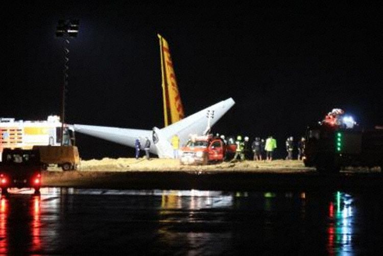
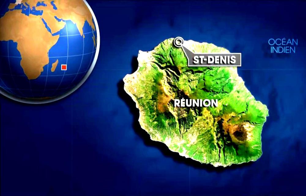
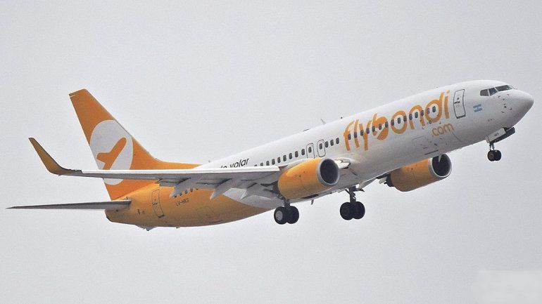
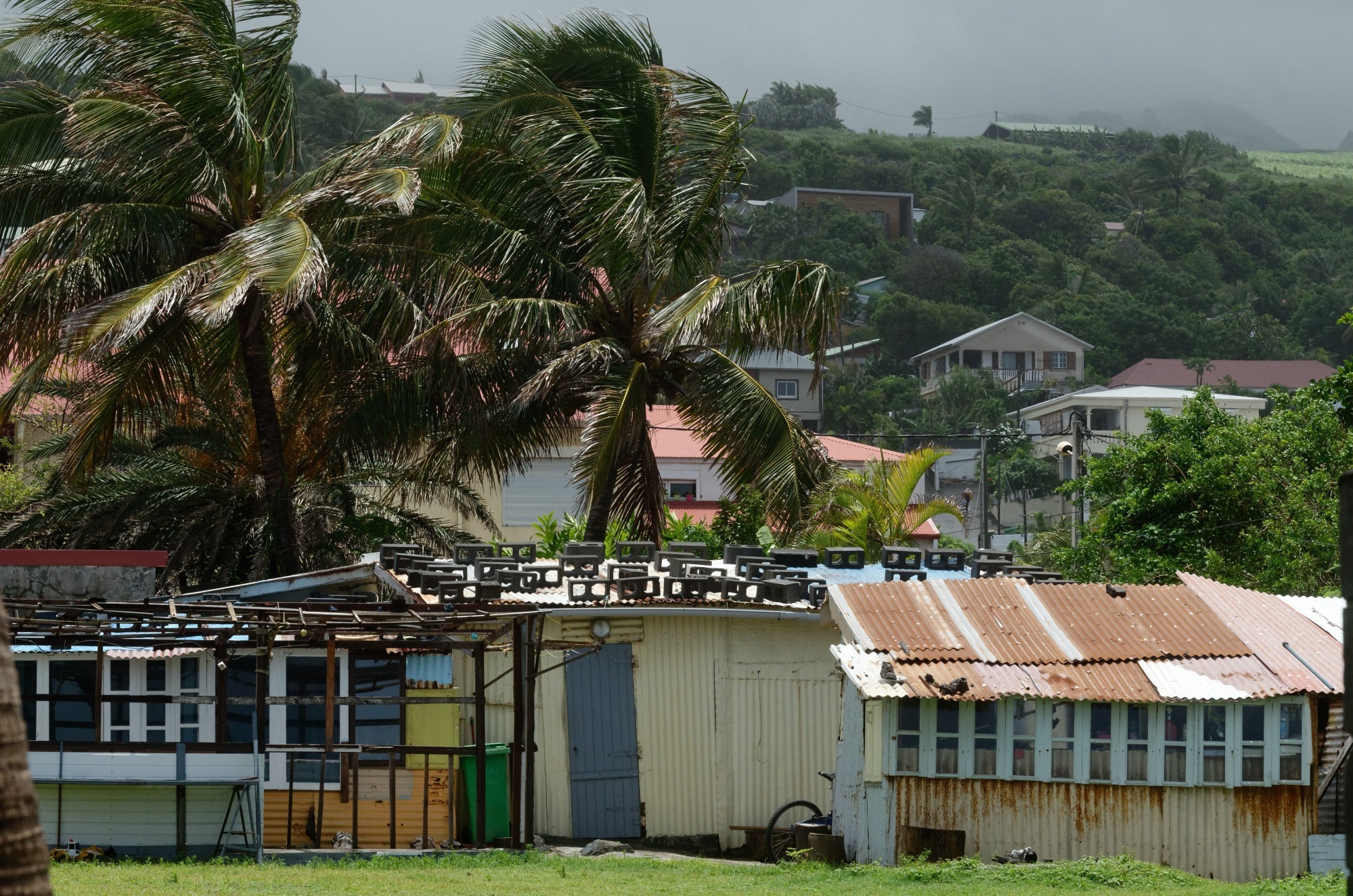
El Aeropuerto Internacional Roland Garros ubicado a 7 kilómetros de Saint-Denis en la Isla Reunión ha sido cerrado por precaución ante el avance del Ciclón Berguita.

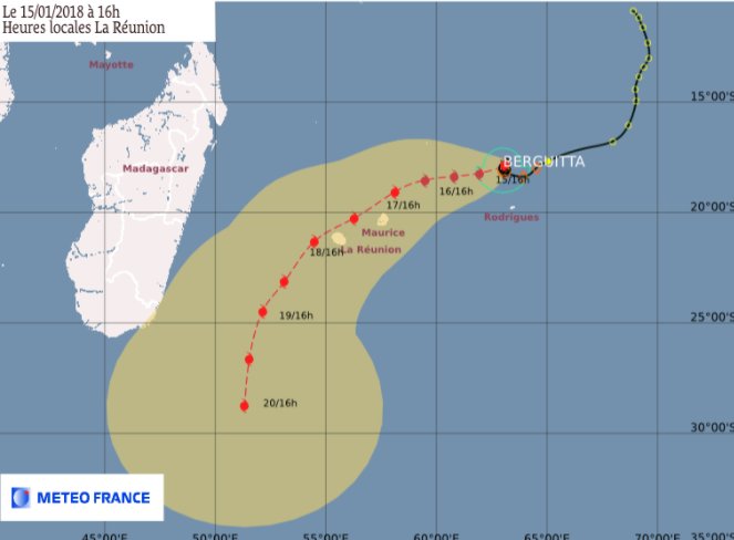
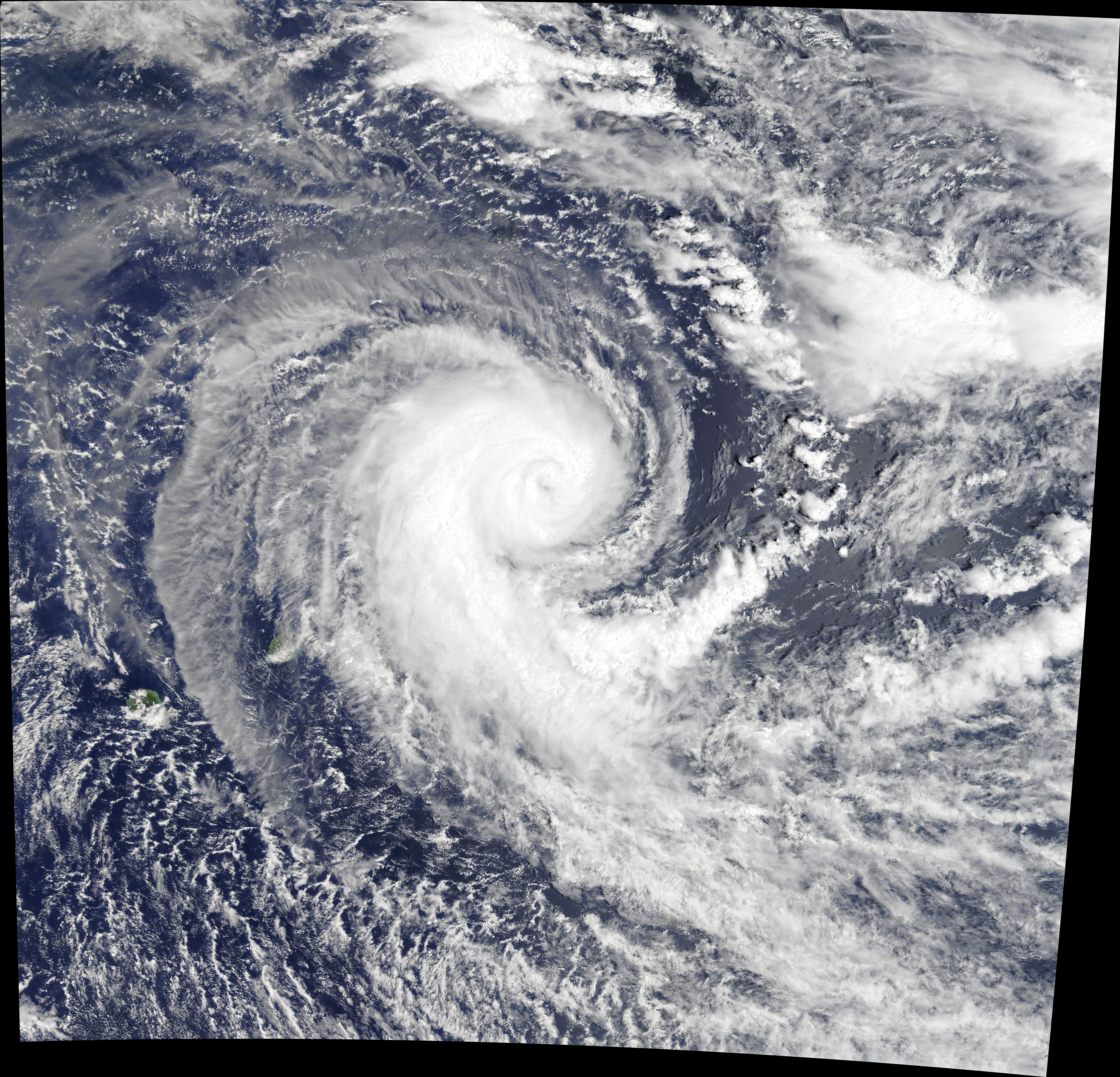
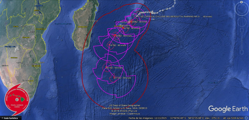
La Isla de la Reunión fue puesta en alerta naranja el miércoles por la mañana, según la prefectura de la isla, a medida que se aproxima la tormenta tropical Berguitta. El ciclón degradado a una «tormenta tropical» se ubicó a poco menos de 500 km al noreste de Reunión. Se espera su paso más cerca de la isla en el día del jueves. «La inflexión de la trayectoria hacia el sudoeste comenzó, acercando más directamente el fenómeno de Mauricio, luego a la Isla Reunión», dijo un comunicado de Météo-France Réunion.

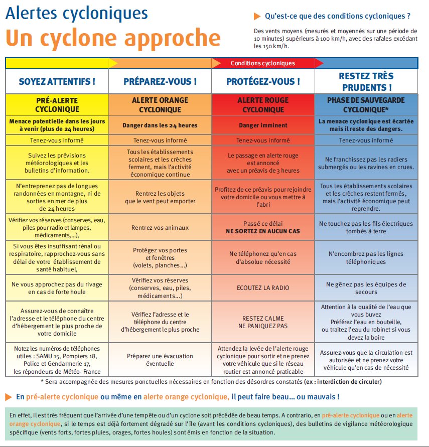
El prefecto de Reunión ha decidido activar el nivel de naranja del dispositivo específico Ciclones ORSEC desde las 08:00 a.m. Desde el lunes la isla estaba en alerta pre-ciclónica. «Anticipación y precaución están a la orden del día», dijo la ministra de ultramar Annick Girardin, que visitó la tarde del miércoles en el Centro Operacional Interdepartamental de Gestión de Crisis (COGIC), donde el fenómeno se monitorea de cerca.

El ministro, que habló por videoconferencia con el prefecto de Reunión, dijo que según las últimas proyecciones, la fuerte tormenta tropical «pasaría por Reunion, en la costa sudeste, con consecuencias en materia de precipitaciones y vientos».

La evolución del Ciclón Berguitta podría ir modificándose para la noche del jueves, 18 de Enero. El cambio a alerta roja todavía no ha sido justificada. «Una brecha de unas pocas decenas de kilómetros de la trayectoria planificada sigue siendo posible. No podemos excluir totalmente en este momento, un paso directo desde el centro de la isla, o ligeramente al norte», confirmó la Reunión Météo-France.

El jueves por la mañana se esperaría las primeras señales de lluvias significativas del paso del ciclón Berguitta, que debería impactar en la Isla Reunion el jueves entre las 15:00—16 hs (hora local).

El Ciclón Beguitta ha sido clasificado el lunes como ciclón tropical intenso que es el último nivel de la clasificación de ciclones en vigor en Reunión. Con el corres de los días Berguitta perdió intensidad y fue degradado a ciclón tropical y tormenta tropical.

Météo France Reunion pronostica lluvias sostenidas en la región este, sur y en las alturas de la isla. La degradación del tiempo debería extenderse a toda Reunión, con la excepción de la región norte.

Berguitta llega mientras la isla ya estaba muy regada la semana pasada por las bandas nubladas de Ava, un ciclón que pasó relativamente cerca de la isla antes de caer en la costa este de Madagascar.

El nivel de alerta naranja se activa cuando una amenaza de ciclón representa una amenaza para la isla dentro de las 24 horas. La vida económica continúa, pero las escuelas están cerradas, lo cual no tiene importancia en este período de vacaciones escolares del verano austral. El aeropuerto también ha sido cerrado por precaución.  AIRWAYS® AW-Icon TXT

Meteofrance.re

Fuertes lluvias desde el miércoles, 17 de enero de 2018 a las 21:00 local.
A medida que se acerca la tormenta tropical Nº 3 BERGUITTA, las lluvias se intensificarán gradualmente en las zonas sur, sureste, este y oeste.
Los umbrales de fuertes lluvias pueden excederse en estas regiones. Por el momento, los valores de lluvia significativos registrados durante 12 horas son:
– 88.5 mm en Gros Piton Sainte-Rose
– 97.4 mm en Baril
– 55.5 mm en el Pas de Bellecombe
Este boletín se actualizará el jueves 18 de enero a las 05h local.
Fuerte viento desde el miércoles 17 de enero de 2018 a las 13:30 hora local.
A medida que se acerca la tormenta tropical Nº 3 BERGUITTA, las ráfagas en el sector sureste se extenderán entre 100 y 120 km / h en las zonas este, sureste, sur y oeste.
Este boletín se actualizará el jueves 18 de enero de 2018 a las 05h local.

berguita-menace-la-reunion-avec-des-rafales-allant-jusqu-a-230-km-h-20180116-1722-1f1d98-0@1x

Reunion island, orange alert by Ciclón Berguitta

Orange alert for Cyclone Berguitta could affect Reunion Island

The Roland Garros International Airport located 7 kilometers from Saint-Denis on Reunion Island has been closed as a precaution against the advance of Cyclone Berguita.

The Island of Reunion was put on orange alert Wednesday morning, according to the prefecture of the island, as the tropical storm Berguitta approaches. The cyclone degraded to a «tropical storm» was located less than 500 km northeast of Réunion. Its passage closer to the island is expected on Thursday. «The inflection of the trajectory towards the southwest began, bringing the phenomenon of Mauritius closer, then to Reunion Island», said a statement from Météo-France Réunion.

The prefect of Reunion has decided to activate the orange level of the specific device Cyclones ORSEC from 08:00 a.m. Since Monday the island was on pre-cyclonic alert. «Anticipation and caution are the order of the day», said overseas minister Annick Girardin, who visited Wednesday afternoon at the Interdepartmental Operational Center for Crisis Management (COGIC), where the phenomenon is monitored closely.

The minister, who spoke by videoconference with the prefect of Reunion, said that according to the latest projections, the strong tropical storm «would pass through Reunion, on the southeast coast, with consequences in terms of rainfall and winds».

The evolution of the Cyclone Berguitta could be modified for the night of Thursday, January 18. The change to red alert has not yet been justified. «A gap of a few tens of kilometers of the planned trajectory is still possible, we can not totally exclude at this moment, a direct passage from the center of the island, or slightly to the north», confirmed the Météo-France Meeting.

On Thursday morning, the first signs of significant rainfall will be expected from the Berguitta cyclone, which should impact on Reunion Island on Thursday between 3:00 pm and 4:00 pm (local time).

The Cyclone Beguitta has been classified on Monday as an intense tropical cyclone that is the last level of the cyclone classification in force in Réunion. With the run of the days Berguitta lost intensity and was degraded to tropical cyclone and tropical storm.

Météo France Reunion forecasts sustained rains in the eastern, southern and high regions of the island. The degradation of time should be extended to all meetings, with the exception of the northern region.

Berguitta arrives while the island was already heavily watered last week by Ava’s cloudy bands, a cyclone that passed relatively close to the island before falling off the east coast of Madagascar.

The orange alert level is activated when a cyclone threat poses a threat to the island within 24 hours. The economic life continues, but the schools are closed, which does not matter in this summer school holiday period. The airport has also been closed as a precaution. A\W

Meteofrance.re

Heavy rains from Wednesday, January 17, 2018 to 21:00 local.
As Tropical Storm No. 3 BERGUITTA approaches, rains will gradually intensify in the South, South-East, East and West zones.
The thresholds of heavy rains may be exceeded in these regions. For the moment, the significant rainfall values recorded over 12 hours are:
– 88.5 mm at Gros Piton Sainte-Rose
– 97.4 mm to the barrel
– 55.5 mm at the Pas de Bellecombe
This bulletin will be updated Thursday, January 18 around 05h local.
Strong wind from Wednesday 17 January 2018 at 13:30 local time.
As Tropical Storm No. 3 BERGUITTA approaches, gusts in the South-East sector will spread between 100 and 120 km / h in the East, South-East, South and West zones.
This bulletin will be updated on Thursday, January 18, 2018 around 05h local.


Île de la Réunion, alerte orange de Ciclón Berguitta

L’alerte orange pour le cyclone Berguitta pourrait affecter l’île de la Réunion

Resultado de imagen para Météo-France RéunionL’Aéroport International Roland Garros situé à 7 kilomètres de Saint-Denis à l’île de la Réunion a été fermé à titre préventif contre l’avance du cyclone Berguita.

L’île de la Réunion a été mise en alerte orange mercredi matin, selon la préfecture de l’île, à l’approche de la tempête tropicale Berguitta. Le cyclone dégradé en «tempête tropicale» était situé à moins de 500 km au nord-est de la Réunion. Son passage plus près de l’île est prévu jeudi. «L’inflexion de la trajectoire vers le sud-ouest a commencé, rapprochant le phénomène de Maurice, puis à La Réunion», indique un communiqué de Météo-France Réunion.

Le préfet de La Réunion a décidé d’activer le niveau orange du dispositif spécifique Cyclones ORSEC à partir de 08h00. Depuis lundi, l’île était en alerte pré-cyclonique. «L’anticipation et la prudence sont à l’ordre du jour», a déclaré Annick Girardin Ministre d’outre-mer, qui a visité mercredi après-midi dans le Centre de gestion de crise opérationnelle interministériel (COGIC), où le phénomène est surveillé de près.

Le ministre, qui a parlé par vidéoconférence avec le préfet de la congrégation, a déclaré que, selon les dernières projections, la forte tempête tropicale «passerait par la Réunion, sur la côte sud-est, avec des conséquences pour les précipitations et les vents».

L’évolution du cyclone Berguitta pourrait être modifiée pour la nuit du jeudi 18 janvier. Le passage à l’alerte rouge n’a pas encore été justifié. «Un écart de quelques dizaines de kilomètres de la trajectoire prévue est encore possible. On ne peut pas exclure complètement à ce moment, un passage direct du centre de l’île, ou un peu au nord» a confirmé la réunion Météo- France.

Jeudi matin, les premiers signes de fortes pluies seront attendus du cyclone Berguitta, qui devrait avoir un impact sur l’île de la Réunion jeudi entre 15h00 et 16h00 (heure locale).

Le Cyclone Beguitta a été classé lundi comme un cyclone tropical intense qui constitue le dernier niveau de la classification des cyclones en vigueur à la Réunion. Au fil des jours, Berguitta perd de son intensité et se dégrade en cyclone tropical et tempête tropicale.

Météo France Réunion prévoit des pluies soutenues dans les régions orientales, méridionales et hautes de l’île. La dégradation du temps devrait être étendue à toutes les réunions, à l’exception de la région du nord.

Berguitta arrive alors que l’île était déjà fortement arrosée la semaine dernière par les bandes nuageuses d’Ava, un cyclone qui est passé relativement près de l’île avant de tomber de la côte est de Madagascar.

Le niveau d’alerte orange est activé lorsqu’une menace de cyclone constitue une menace pour l’île dans les 24 heures. La vie économique continue, mais les écoles sont fermées, ce qui n’a pas d’importance en cette période de vacances scolaires d’été. L’aéroport a également été fermé par mesure de précaution. A \ W

Meteofrance.re

Fortes pluies à partir de Mercredi 17 Janvier 2018 à 21h00 locales.
A l’approche de la Forte Tempête Tropicale n°3 BERGUITTA, les pluies vont progressivement s’intensifier sur les zones Sud, Sud-Est, Est et Ouest.
Les seuils de fortes pluies pourront être dépassées sur ces régions. Pour l’instant, les valeurs de pluviométries significatives relevées sur 12 h sont :
– 88,5 mm à Gros Piton Sainte-Rose
– 97.4 mm au Baril
– 55.5 mm au Pas de Bellecombe
Ce bulletin sera réactualisé Jeudi 18 Janvier vers 05h locales.
Vent fort à partir du Mercredi 17 Janvier 2018 à 13h30 locales.
A l’approche de la Forte Tempête Tropicale n°3 BERGUITTA, les rafales de secteur Sud-Est vont se généraliser entre 100 et 120 km/h sur les zones Est, Sud-Est, Sud et et Ouest.
Ce bulletin sera réactualisé le Jeudi 18 Janvier 2018 vers 05h locales.


Ξ A I R G W A Y S Ξ
SOURCE:  Airgways.com
DBk: Meteo-reunion.com / Meteofrance.re / Twitter.com [Préfet de La Réunion]
AW-POST: 201801171952AR

A\W   A I R G W A Y S ®

Aerolíneas EEUU cancelan 1.600 vuelos

AW | 2018 01 17 10:14 | AVIATION SAFETY

Las aerolíneas de Estados Unidos ha cancelado 1.600 vuelos y más de 3.100 retrasos por el temporal invernal

Las aerolíneas estaban cancelando vuelos y renunciando a las tarifas de cambio ya que el clima invernal amenazaba los aeropuertos en una gran franja de los Estados Unidos el martes.

Cerca de 1.600 vuelos fueron cancelados y otros 3.100 retrasados ​​a partir de las 6 p.m. ET, según el servicio de seguimiento de vuelos FlightAware. El miércoles parecía que también sería complicado para los pasajeros, con más de 340 vuelos ya aterrizados.

Región Sur

La mayor interrupción del martes se produjo en el Aeropuerto Intercontinental Houston Bush, el centro más activo de United Airlines. Cerca de 800 vuelos habían sido puestos a tierra a las 5 p.m. hora local, que representa aproximadamente un tercio del horario diario completo del aeropuerto. El Aeropuerto de Atlanta, el aeropuerto más activo del mundo se esperaba que el clima invernal comenzara a caer allí la noche del martes. Delta Air Lines, canceló cerca de 275 vuelos el martes, principalmente en la noche antes del mal tiempo. Afortunadamente para los pasajeros, se esperaba que el clima mejorara el miércoles. El Aeropuerto de Houston Hobby también fue duramente golpeado. reportándose alrededor de 225 cancelaciones a partir de las 5 p.m. hora local, que representa aproximadamente la mitad del horario del martes.

En términos más generales, los viajeros deberían prepararse para las demoras y las interrupciones en todo el sur a medida que el clima invernal se adentraba en la región. El martes por la noche también se registraron tasas de retrasos y cancelaciones superiores a la media en los aeropuertos de Austin, Dallas Love, Dallas/Fort Worth, San Antonio y Nueva Orleans. La mayoría de las grandes aerolíneas estaban renunciando a tarifas de cambio de reserva para varios aeropuertos en Texas.

Región Noreste

Eso también fue cierto en el noreste, donde se pronosticaba que la nieve leve a moderada caería en gran parte de la región. Se pronostica que varios de los aeropuertos más concurridos de la nación, incluidos los que prestan servicios a Nueva York, Washington, Baltimore, Boston y Filadelfia, acumularán nieve la noche del martes al miércoles. Nueva Inglaterra también podrían sufrir los retrazos y cancelaciones de vuelos por la remoción de nieve y hielo. Alrededor de 60 vuelos fueron cancelados en Boston el martes, y se espera que las condiciones empeoren el miércoles. Otros lugares que estarán afectados son Charlotte, Nashville, Louisville y Richmond, Virginia. AIRWAYS® AW-Icon TXT

US airlines cancel 1,600 flights

US airlines have canceled 1,600 flights and more than 3,100 delays due to the winter weather

The airlines were canceling flights and waiving exchange rates as winter weather threatened airports in a large swath of the United States on Tuesday.

About 1,600 flights were canceled and another 3,100 delayed as of 6 p.m. ET, according to FlightAware flight tracking service. On Wednesday it seemed that it would also be difficult for passengers, with more than 340 flights already landed.

Southern region

The biggest disruption on Tuesday occurred at the Houston Bush Intercontinental Airport, the busiest hub of United Airlines. Nearly 800 flights had been grounded at 5 p.m. local time, which represents approximately one third of the airport’s entire daily schedule. The Atlanta Airport, the busiest airport in the world, expected the winter weather to start falling there Tuesday night. Delta Air Lines, canceled about 275 flights on Tuesday, mainly on the night before bad weather. Fortunately for the passengers, the weather was expected to improve on Wednesday. The Houston Hobby Airport was also hit hard. reporting about 225 cancellations starting at 5 p.m. local time, which represents approximately half of Tuesday’s schedule.

More generally, travelers should prepare for delays and disruptions throughout the south as winter weather penetrated the region. Late-night delays and cancellations at airports in Austin, Dallas Love, Dallas/Fort Worth, San Antonio and New Orleans were also recorded late Tuesday. Most of the major airlines were waiving reserve change rates for several airports in Texas.

Northeast Region

That was also true in the Northeast, where mild to moderate snow was forecast to fall in much of the region. Several of the nation’s busiest airports, including those serving New York, Washington, Baltimore, Boston and Philadelphia, are forecast to accumulate snow Tuesday night through Wednesday. New England could also suffer the delays and cancellations of flights by the removal of snow and ice. About 60 flights were canceled in Boston on Tuesday, and conditions are expected to worsen on Wednesday. Other places that will be affected are Charlotte, Nashville, Louisville and Richmond, Virginia. A \ W


Ξ A I R G W A Y S Ξ
SOURCE:  Airgways.com
DBk: Accuweather.com / Flexiroam.com / Thepointsguy.com
AW-POST: 201801171014AR

A\W   A I R G W A Y S ®

Alerta ciclón Berguitta en Isla Mauricio

AW | 2018 01 17 09:52 | AVIATION SAFETY / SAFETY / SECURITY

Ciclón Berguitta afecta Isla Mauricio en el Océano Índico

La Isla de Mauricio ubicada en el Océano Índico, cerró su puerto y aeropuerto hoy miércoles luego de advertir que un ciclón tropical potencialmente peligroso se aproximaba a la nación isleña del Océano Índico.

Los servicios meteorológicos de la isla dijeron que «Berguitta«, un ciclón de categoría III, se encontraba a 340 km (210 millas) al noreste de Mauricio antes del amanecer del miércoles y se movía en dirección suroeste a 7 km/h (4 mph). Las autoridades elevaron su alerta a la clase III cuando el ciclón tropical Berguitta se acercó para permitir al menos seis horas de luz natural antes de la llegada de ráfagas de hasta 120 km/h (75 mph).

«En esta trayectoria, el ciclón tropical Berguitta se acerca peligrosamente a la Isla Mauricio y representa una amenaza directa para la isla», dijo el servicio meteorológico en un comunicado. Advirtió al público que tome precauciones de seguridad y dijo que podrían esperarse ráfagas que alcancen los 120 km/h el miércoles por la noche, lo que provocaría condiciones de mar embravecidas.

El Aeropuerto Internacional de Mauricio dijo que el aeropuerto estaría cerrado desde las 7 a.m. (0300 GMT) hasta nuevo aviso. Port Louis, el puerto principal, también estaba cerrado. Es la principal puerta de entrada del país y maneja aproximadamente el 99% del volumen total del comercio exterior. AIRWAYS® AW-Icon TXT

Tropical cyclone alert Berguitta in Mauritius

Resultado de imagen para Mauritius Island globe map pngCyclone Berguitta affects Mauritius in the Indian Ocean

The island of Mauritius located in the Indian Ocean, closed its port and airport Wednesday after noting that a potentially dangerous tropical cyclone was approaching the island nation of the Indian Ocean.

Meteorological services on the island said that «Berguitta«, a Category III cyclone, was 340 km (210 miles) northeast of Mauritius before dawn on Wednesday and was moving southwest at 7 km/h (4 mph). Authorities raised their alert to class III when tropical cyclone Berguitta approached to allow at least six hours of natural light before the arrival of bursts of up to 120 km/h (75 mph).

«In this trajectory, tropical cyclone Berguitta is dangerously close to Mauritius and represents a direct threat to the island», the meteorological service said in a statement.He warned the public to take safety precautions and said that gusts of up to 120 km / h could be expected on Wednesday night, which would cause raging sea conditions.

The Mauritius International Airport said the airport would be closed from 7 a.m. (0300 GMT) until further notice. Port Port Louis, the main port, was also closed. It is the main gateway to the country and handles approximately 99% of the total volume of foreign trade. A \ W


Ξ A I R G W A Y S Ξ
SOURCE:  Airgways.com
DBk: Gdacs.org
AW-POST: 201801170942AR

A\W   A I R G W A Y S ®

Accidente Boeing 737-800 de Pegasus

AW | 2018 01 14 11:06 | AVIATION SAFETY

Un Boeing 737-800 derrapa en pendiente en Aeropuerto de Trabzon, Turquía

Un Boeing 737-800, registro TC-CPF de Pegasus Airlines efectuó el vuelo PC-8622 de Ankara a Trabzon (Turquía) con 162 pasajeros y 6 tripulantes. Al momento de efectuar el aterrizaje en la pista 11 de Trabzon a las 23: 26L (20: 26Z) viró a la izquierda de la pista y descendió por la pendiente al costado de la pista y se detuvo en un terreno blando, a unos 60 metros del mar antes del final de la pista y unos 60 metros a la izquierda del borde de la pista izquierda. El avión fue evacuado. No hubo heridos, el avión sufrió daños sustanciales.

La aerolínea confirmó que el vuelo PC-8622 tuvo un incidente en la pista cuando aterrizó en Trabzon. El avión transportaba a 162 pasajeros, 2 pilotos y 4 tripulantes, todos desembarcaron de manera segura, no hubo heridos. El gobernador de Trabzon informó que no hubo heridos. Los servicios de emergencia locales informaron que 3 personas fueron llevadas a hospitales con lesiones menores.

Los datos sugieren que la aeronave aterrizó normalmente a 143 nudos sobre el suelo. El incidente ocurrió el sábado por la noche en el aeropuerto de Trabzon, en el noreste de Turquía.

Vuelo de Pegasus Airlines se desliza fuera de la pista turca en la costa del Mar Negro, los pasajeros escapan ilesos. El incidente ocurrió el sábado por la noche en el aeropuerto de Trabzon, en el noreste de Turquía. Tras el aterrizaje del Boeing 737-800 terminó a mitad de camino en una empinada ladera del Aeropuerto de Trabzon en el Mar Negro. AIRWAYS® AW-Icon TXT

DTfIwtWX0AEj_prDTfIxblX0AE_o5eDTfIyMVXUAA6Hbhpegasus_b738_tc-cpf_trabzon_180113_1

Accident Boeing 737 Pegasus in Trabzon

A Boeing 737-800 skid slopes at Trabzon Airport, Turkey

A Boeing 737-800, registration TC-CPF of Pegasus Airlines made the PC-8622 flight from Ankara to Trabzon (Turkey) with 162 passengers and 6 crew members. At the time of landing on runway 11 of Trabzon at 23: 26L (20: 26Z) he turned left of the runway and descended the slope on the side of the runway and stopped on soft ground, about 60 meters from the sea before the end of the track and about 60 meters to the left of the edge of the left track. The plane was evacuated. There were no injuries, the plane suffered substantial damage.

The airline confirmed that flight PC-8622 had an incident on the runway when it landed in Trabzon. The plane was carrying 162 passengers, 2 pilots and 4 crew members, all disembarked safely, there were no injuries. The governor of Trabzon reported that there were no injuries. Local emergency services reported that 3 people were taken to hospitals with minor injuries.

DTfkw4vXcAAJxVu

The data suggest that the aircraft landed normally at 143 knots above the ground. The incident occurred on Saturday night at the Trabzon airport in northeastern Turkey.

Pegasus Airlines flight slides off the Turkish track on the Black Sea coast, passengers escape unharmed. The incident occurred on Saturday night at the Trabzon airport in northeastern Turkey. After landing the Boeing 737-800 ended halfway on a steep slope of the Trabzon Airport on the Black Sea. A \ W

VIDEO > https://player.vimeo.com/video/251020866«>

Ξ A I R G W A Y S Ξ
SOURCE:  Airgways.com
DBk: Avherald.com / Flypgs.com / Turkish Air News (@AnalystTK) / Jacdec.de / Vimeo..com [Erhan Aydoğdu]

AW-POST: 201801141106AR

A\W   A I R G W A Y S ®