Huracán Dorian | Día 31/08

 In a recent satellite image, the eye of the storm could be seen barrelling towards Florida's eastern coast

AW | 2019 08 31 20:01 | AVIATION SAFETY / AIR TRAFFIC

1f300Centenares cancelaciones de vuelos por aproximación Huracán Dorian en Categoría 4

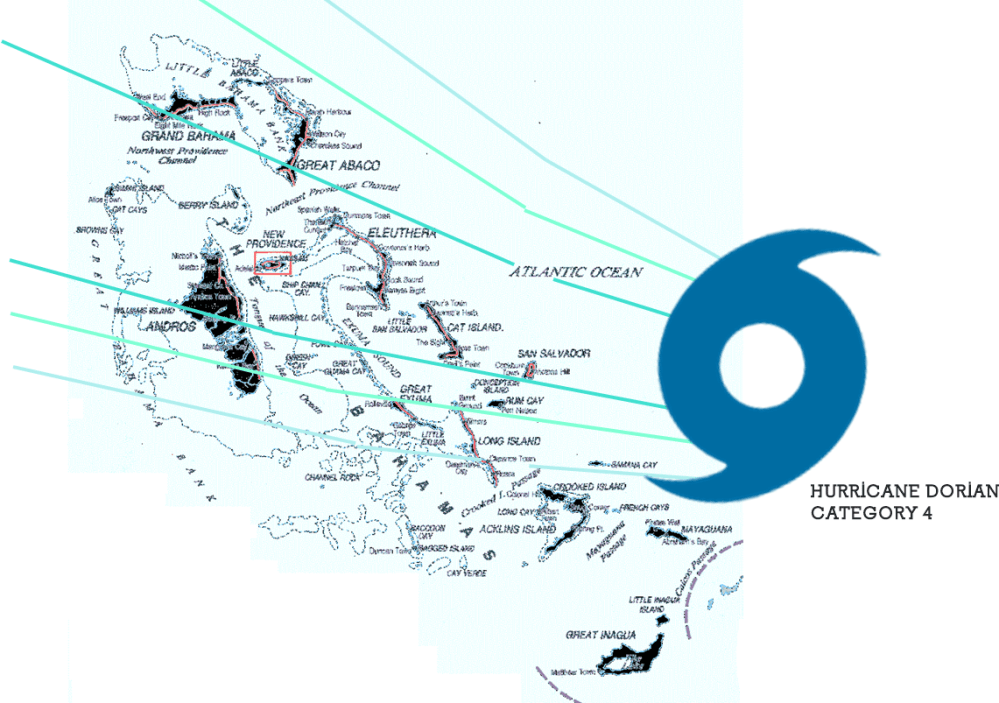
El Huracán Dorian ha ingresado en Categoría 4, y se dirige hacia las Islas Bahamas y el sudeste de los Estados Unidos. El último pronóstico informa que el Huracán Dorian está girando hacia el norte bordeando la costa este del Estado de Florida.

El huracán tiene actualmente vientos de 150 mph, lo que lo convierte en un huracán Categoría 4 extremadamente peligroso. Una advertencia de huracán está actualmente vigente para el noroeste de Bahamas. La tormenta podría llegar tarde este fin de semana hasta el Lunes 02/09, y traer consigo de 10 a 15 pies de marejada, y de 10 a 25 pulgadas de lluvia, creando una situación extremadamente peligrosa y potencialmente mortal. En las Bahamas, “los preparativos para proteger la vida y la propiedad deben apresurarse hasta su finalización”, advierte el Centro Nacional de Huracanes (NHC).

Pronóstico alerta Huracán

Islas Bahamas

El Huracán Dorian está ganando intensidad y tiene la vista puesta en las Islas Bahamas. El pronóstico con alerta temprana está dado para las Islas Bahamas para hoy Sábado 31/08, impactando el Huracán Dorian sobre la línea de las San Salvador Island, Cat Island, Eleuthera Island, Harbour Island, Paradise Island, The Abacos Islands, Berry Island, Grand Bahama Island, Bimini Island que son las que recibirán mayor impacto.

AW-Dorian31-08.png

Estados de Florida/Georgia/Carolinas

Para el Estado de Florida el pronóstico establece una dirección sureste hacia los Estados Unidos con un impacto en a través de la costa este de Florida, Georgia y Carolina del Sur y Carolina del Norte a mediados de la próxima semana. Para prepararse para todas estas amenazas, el Gobernador del Estado de Florida Ron DeSantis ha declarado un estado de emergencia, liberando recursos para prepararse para la tormenta.

Después de eso, todavía no se sabe exactamente dónde Dorian atacará a los Estados Unidos. Los impactos son posibles a lo largo de toda la costa atlántica de Florida y en Georgia y las Carolinas. El NHC emitió una alerta de tormenta tropical para partes de la costa de Florida, lo que significa que las condiciones de tormenta tropical son posibles en los próximos días. También es posible que la tormenta se detenga o disminuya a lo largo de la costa, prolongando la exposición de la región a las condiciones de huracán. “Los residentes deben tener su plan de huracanes en su lugar, saber si están en una zona de evacuación de huracanes y escuchar los consejos de los funcionarios locales de emergencia”, aconseja el NHC.

Los vientos con fuerza de tormenta tropical podrían llegar a Florida el domingo. Sin embargo, gran parte del impacto en Florida todavía es incierto. “Dado que Dorian se prevé para frenar y girar hacia el norte a medida que se acerca a los vientos de la costa, las mareas de tempestad que amenaza la vida y peligroso huracanados son todavía posibles a lo largo de porciones de la costa este de Florida a principios de la parte media de la próxima semana”, informa NHC.

El aspecto más letal de un huracán tiende a ser una marejada ciclónica (inundaciones causadas por el agua de mar empujada a tierra por los vientos del huracán). El NHC aún no tiene un pronóstico de marejada ciclónica para Florida, pero advierte que son posibles inundaciones potencialmente mortales. También es posible que el epicentro del huracán no toque tierra en el Estado de Florida: los modelos de pronóstico del NHC se han desplazado un poco hacia el Este sobre el Océano Atlántico. Dorian, aún presentaría una situación peligrosa, con olas fuertes, vientos fuertes y lluvia, pero no el peor de los casos. De nuevo, todavía no se sabe exactamente dónde impactará Dorian, por lo que recomiendan tomar las medidas pertinentes de seguridad y estar muy informados de los últimos detalles de los pronósticos meteorológicos.

La tormenta de 150 mph cambió su rumbo y podría rozar la costa de Florida y continuar hacia Georgia y Carolina del Norte y del Sur. Hace tres años atrás, el Huracán Matthew de Categoría 5 tuvo la misma trayectoria al abrazar la costa sureste del país sin dejar de causar miles de millones de dólares en daños.

Cancelaciones de vuelos

Los efectos del Huracán Dorian se han cancelaron más de 400 vuelos. A partir de esta mañana 31/08, y otros 200 vuelos fueron cancelados en Estados Unidos programados para el Domingo 01/09.

Las aerolíneas han estado emitiendo exenciones a los clientes durante varios días para viajes que se dirigen a destinos en el camino del huracán, se emitirán más opciones de exención para las Carolinas a medida que el Huracán Dorian se mueva hacia el norte por la costa este.

Las operaciones en el Aeropuerto Internacional de Orlando se suspenderán a las 2 am del Lunes 01/09, hora local, según un comunicado oficial. El Aeropuerto Internacional de Miami y el aeropuerto internacional de Fort Lauderdale aún no han confirmado qué medidas tomarán y están monitoreando el camino del huracán.AW-Icon-AW-TXT

Resultado de imagen para hurricane dorian mapHurricane Dorian | Day 31/08

Hundreds of flight cancellations due to Hurricane Dorian approach in Category 4

Hurricane Dorian has entered Category 4 and is heading towards the Bahamas Islands and the southeastern United States. The latest forecast reports that Hurricane Dorian is turning north along the east coast of the State of Florida.

The hurricane currently has 150 mph winds, which makes it an extremely dangerous Category 4 hurricane. A hurricane warning is currently in effect for the northwestern Bahamas. The storm could be late this weekend until Monday 02/09 and bring with it 10 to 15 feet of storm surge, and 10 to 25 inches of rain, creating an extremely dangerous and life-threatening situation. In the Bahamas, “preparations to protect life and property must hurry to completion”, warns the National Hurricane Center (NHC).

cone graphic

Hurricane Alert Forecast

Bahamas Islands

Hurricane Dorian is gaining intensity and has its sights set on the Bahamas Islands. The forecast with early warning is given for the Bahamas for today Saturday 31/08, impacting Hurricane Dorian on the line of San Salvador Island, Cat Island, Eleuthera Island, Harbor Island, Paradise Island, The Abacos Islands, Berry Island, Grand Bahama Island, Bimini Island which are the ones that will receive the greatest impact.

Florida States / Georgia / Carolinas

For the State of Florida, the forecast establishes a southeast direction to the United States with an impact on the east coast of Florida, Georgia and South Carolina and North Carolina in the middle of next week. To prepare for all these threats, Florida State Governor Ron DeSantis has declared a state of emergency, freeing up resources to prepare for the storm.

After that, it is not yet known exactly where Dorian will attack the United States. Impacts are possible along the entire Atlantic coast of Florida and in Georgia and the Carolinas. The NHC issued a tropical storm alert for parts of the Florida coast, which means that tropical storm conditions are possible in the coming days. It is also possible for the storm to stop or decrease along the coast, prolonging the region’s exposure to hurricane conditions. “Residents should have their hurricane plan in place, know if they are in a hurricane evacuation zone and listen to the advice of local emergency officials”, advises the NHC.

Winds with tropical storm force could reach Florida on Sunday. However, much of the impact in Florida is still uncertain. “Since Dorian is expected to slow down and turn north as the winds of the coast get closer, storm surges that threaten life and dangerous hurricanes are still possible along portions of the east coast of Florida at the beginning of the middle part of next week”, reports NHC.

The most lethal aspect of a hurricane tends to be a storm surge (floods caused by seawater pushed ashore by hurricane winds). The NHC does not yet have a storm surge forecast for Florida but warns that life-threatening floods are possible. It is also possible that the epicenter of the hurricane does not touch land in the State of Florida: NHC forecast models have shifted a little eastward over the Atlantic Ocean. Dorian, would still present a dangerous situation, with strong waves, strong winds, and rain, but not the worst case. Again, it is not yet known exactly where Dorian will impact, so they recommend taking the appropriate safety measures and being very informed of the latest details of the weather forecasts.

The 150 mph storm changed course and could touch the Florida coast and continue to Georgia and North and South Carolina. Three years ago, Category 5 Hurricane Matthew had the same trajectory in embracing the southeast coast of the country while still causing billions of dollars in damages.

Flight Cancellations

The effects of Hurricane Dorian have been canceled more than 400 flights. As of this morning, 08/31, and another 200 flights were canceled in the United States scheduled for Sunday 01/09.

Airlines have been issuing exemptions to customers for several days for trips to destinations on the path of the hurricane, more exemption options will be issued for the Carolinas as Hurricane Dorian moves north along the east coast.

Operations at the Orlando International Airport will be suspended at 2 am on Monday 01/09, local time, according to an official statement. The Miami International Airport and the Fort Lauderdale International Airport have not yet confirmed what measures they will take and are monitoring the path of the hurricane. A \ W


Asesor Público del Huracán Dorian

000
WTNT35 KNHC 312051
TCPAT5

BOLETÍN
Huracán Dorian Número asesor 30
NWS National Hurricane Center Miami FL AL052019
500 PM EDT sáb 31 ago 2019

... DURIAN DE HURACANES GRAVES ESPERADO PARA GOLPAR PORCIONES DEL
BAHAMAS DEL NOROESTE DURO EL DOMINGO ...


RESUMEN DE 500 PM EDT ... 2100 UTC ... INFORMACIÓN
----------------------------------------------
UBICACIÓN ... 26.2N 74.4W
ACERCA DE 170 MI ... 270 KM E DE LA GRAN ISLA ABACO
ACERCA DE 355 MI ... 570 KM E DE WEST PALM BEACH FLORIDA
VIENTOS MÁXIMOS SOSTENIDOS ... 150 MPH ... 240 KM / H
MOVIMIENTO ACTUAL ... W O 280 GRADOS A 8 MPH ... 13 KM / H
PRESIÓN CENTRAL MÍNIMA ... 945 MB ... 27.91 PULGADAS


RELOJES Y ADVERTENCIAS
--------------------
CAMBIOS CON ESTA ADVERTENCIA:

Se emitió una alerta de tormenta tropical para la costa este de Florida
desde Deerfield Beach hasta Sebastian Inlet.

RESUMEN DE RELOJES Y ADVERTENCIAS EN EFECTO:

Una advertencia de huracán está vigente para ...
* El noroeste de Bahamas, excluyendo la isla de Andros

Una alerta de huracán está vigente para ...
* Isla de Andros

Una vigilancia de tormenta tropical está vigente para ...
* Deerfield Beach a Sebastian Inlet

Una advertencia de huracán significa que se esperan condiciones de huracán
en algún lugar dentro del área de advertencia. Preparativos para proteger la vida y
La propiedad debe ser apresurada para su finalización.

Una alerta de huracán significa que las condiciones de huracán son posibles
dentro del área de vigilancia.

Una vigilancia de tormenta tropical significa que las condiciones de tormenta tropical son
posible dentro del área de vigilancia, generalmente dentro de las 48 horas.

Los intereses en otras partes del sur y centro de Florida deberían continuar
para monitorear el progreso de Dorian. Relojes adicionales pueden ser
requerido para porciones de la costa este de Florida esta noche o
Domingo.

Para obtener información sobre tormentas específica para su área en los Estados Unidos,
incluidas posibles alertas y advertencias en el interior, controle
productos emitidos por su pronóstico local del Servicio Meteorológico Nacional
oficina. Para información sobre tormentas específica de su área fuera del
Estados Unidos, controle los productos emitidos por su nacional
servicio meteorologico.


DISCUSIÓN Y PERSPECTIVAS
----------------------
A las 500 PM EDT (2100 UTC), el ojo distintivo del huracán Dorian fue
ubicado cerca de la latitud 26.2 norte, longitud 74.4 oeste. Dorian es
moviéndose hacia el oeste cerca de 8 mph (13 km / h), y más lento hacia el oeste
la moción debe continuar durante el día o dos siguientes, seguida de una
giro gradual hacia el noroeste. En esta pista, el núcleo de Dorian
debe moverse cerca o sobre partes del noroeste de Bahamas en
Domingo, y muévete más cerca de la costa este de Florida a última hora del lunes
hasta el martes

Los vientos máximos sostenidos permanecen cerca de 150 mph (240 km / h) con mayor
ráfagas Dorian es un huracán de categoría 4 en Saffir-Simpson
Escala de viento de huracán. Es probable que haya algunas fluctuaciones en la intensidad,
pero se espera que Dorian siga siendo un poderoso huracán durante el
próximos días.

Los vientos huracanados se extienden hacia afuera hasta 30 millas (45 km) del
vientos centrales y de fuerza de tormenta tropical se extienden hacia afuera hasta 105 millas
(165 km).

La presión central mínima estimada es de 945 mb (27,91 pulgadas).


PELIGROS QUE AFECTAN LA TIERRA
----------------------
VIENTO: se esperan condiciones de huracán en la advertencia de huracán
área en todo el noroeste de Bahamas el domingo, con tormenta tropical
vientos que comienzan esta noche.

Las condiciones de tormenta tropical son posibles dentro de la tormenta tropical
área de vigilancia el lunes.

OLEADA DE TORMENTA: Una marejada ciclónica potencialmente mortal elevará los niveles de agua
hasta 10 a 15 pies por encima de los niveles normales de marea en áreas de
vientos en tierra las Islas Abaco y la Isla Gran Bahama. Cerca de
costa, el oleaje estará acompañado por olas grandes y destructivas.

LLUVIA: Se espera que Dorian produzca la siguiente lluvia
acumulaciones este fin de semana a mediados de la próxima semana:

Noroeste de Bahamas ... 10 a 15 pulgadas, aislado 25 pulgadas.
Secciones costeras del sureste de los Estados Unidos ... 4 a 8 pulgadas,
Aislados 12 pulgadas.
Bahamas central ... 2 a 4 pulgadas, aislado 6 pulgadas.

Esta lluvia puede causar inundaciones repentinas que amenazan la vida.

SURF: las olas comenzarán a afectar las costas orientadas al este de
Bahamas, la costa este de Florida y el sureste de los Estados Unidos
costa durante los próximos días. Es probable que estas inflamaciones causen
condiciones actuales de surf y rip que amenazan la vida. Por favor consulta
productos de su oficina meteorológica local.


PRÓXIMA ADVERTENCIA
-------------
Próximo aviso intermedio a las 800 PM EDT.
Siguiente aviso completo a las 1100 PM EDT.

$$
Pronosticador Ávila / Brennan


Hurricane Dorian Public Advisory

000
WTNT35 KNHC 312051
TCPAT5

BULLETIN
Hurricane Dorian Advisory Number  30
NWS National Hurricane Center Miami FL       AL052019
500 PM EDT Sat Aug 31 2019

...SEVERE HURRICANE DORIAN EXPECTED TO HIT PORTIONS OF THE
NORTHWESTERN BAHAMAS HARD ON SUNDAY...


SUMMARY OF 500 PM EDT...2100 UTC...INFORMATION
----------------------------------------------
LOCATION...26.2N 74.4W
ABOUT 170 MI...270 KM E OF GREAT ABACO ISLAND
ABOUT 355 MI...570 KM E OF WEST PALM BEACH FLORIDA
MAXIMUM SUSTAINED WINDS...150 MPH...240 KM/H
PRESENT MOVEMENT...W OR 280 DEGREES AT 8 MPH...13 KM/H
MINIMUM CENTRAL PRESSURE...945 MB...27.91 INCHES


WATCHES AND WARNINGS
--------------------
CHANGES WITH THIS ADVISORY:

A Tropical Storm Watch has been issued for the east coast of Florida
from Deerfield Beach to Sebastian Inlet.

SUMMARY OF WATCHES AND WARNINGS IN EFFECT:

A Hurricane Warning is in effect for...
* Northwestern Bahamas excluding Andros Island

A Hurricane Watch is in effect for...
* Andros Island

A Tropical Storm Watch is in effect for...
* Deerfield Beach to Sebastian Inlet

A Hurricane Warning means that hurricane conditions are expected
somewhere within the warning area. Preparations to protect life and
property should be rushed to completion.

A Hurricane Watch means that hurricane conditions are possible
within the watch area.

A Tropical Storm Watch means that tropical storm conditions are
possible within the watch area, generally within 48 hours.

Interests elsewhere in southern and central Florida should continue
to monitor the progress of Dorian.  Additional watches may be
required for portions of the east coast of Florida tonight or
Sunday.

For storm information specific to your area in the United States,
including possible inland watches and warnings, please monitor
products issued by your local National Weather Service forecast
office. For storm information specific to your area outside of the
United States, please monitor products issued by your national
meteorological service.


DISCUSSION AND OUTLOOK
----------------------
At 500 PM EDT (2100 UTC), the distinct eye of Hurricane Dorian was
located near latitude 26.2 North, longitude 74.4 West. Dorian is
moving toward the west near 8 mph (13 km/h), and a slower westward
motion should continue for the next day or two, followed by a
gradual turn toward the northwest. On this track, the core of Dorian
should move be near or over portions of the northwestern Bahamas on
Sunday, and move closer to the Florida east coast late Monday
through Tuesday.

Maximum sustained winds remain near 150 mph (240 km/h) with higher
gusts.  Dorian is a category 4 hurricane on the Saffir-Simpson
Hurricane Wind Scale.  Some fluctuations in intensity are likely,
but Dorian is expected to remain a powerful hurricane during the
next few days.

Hurricane-force winds extend outward up to 30 miles (45 km) from the
center and tropical-storm-force winds extend outward up to 105 miles
(165 km).

The estimated minimum central pressure is 945 mb (27.91 inches).


HAZARDS AFFECTING LAND
----------------------
WIND:  Hurricane conditions are expected in the hurricane warning
area across the northwestern Bahamas by Sunday, with tropical storm
winds beginning tonight.

Tropical storm conditions are possible within the tropical storm
watch area on Monday.

STORM SURGE:  A life-threatening storm surge will raise water levels
by as much as 10 to 15 feet above normal tide levels in areas of
onshore winds the Abaco Islands and Grand Bahama Island. Near the
coast, the surge will be accompanied by large and destructive waves.

RAINFALL:  Dorian is expected to produce the following rainfall
accumulations this weekend into the middle of next week:

Northwestern Bahamas...10 to 15 inches, isolated 25 inches.
Coastal sections of the southeast United States...4 to 8 inches,
isolated 12 inches.
Central Bahamas...2 to 4 inches, isolated 6 inches.

This rainfall may cause life-threatening flash floods.

SURF:  Swells will begin affect the east-facing shores of the
Bahamas, the Florida east coast, and the southeastern United States
coast during the next few days.  These swells are likely to cause
life-threatening surf and rip current conditions.  Please consult
products from your local weather office.


NEXT ADVISORY
-------------
Next intermediate advisory at 800 PM EDT.
Next complete advisory at 1100 PM EDT.

$$
Forecaster Avila/Brennan


Resultado de imagen para red cross logo

HURRICANE SAFETY CHECKLIST

Right-Arrow-PNG-Image-with-Transparent-Backgroundhttps://www.redcross.org/content/dam/redcross/atg/PDF_s/Preparedness___Disaster_Recovery/Disaster_Preparedness/Hurricane/Hurricane.pdf


Ξ A I R G W A Y S Ξ
SOURCE: Airgways.com
DBk: Nhc.noaa.gov / Thesun.co.uk / Airgways.com / Ap.org / Accuweather.com
AW-POST: 201908312001AR

A\W   A I R G W A Y S ®

“Flying preference”

AW-7000000.pngAW | 2019 08 31 16:23 | AW EDITORIAL

En Airgways.com estamos comprometidos a superarnos día a día brindando la mejor atención a nuestros “pasajeros frecuentes”, que mañana a mañana, día tras día en cada rincón del planeta los amantes de la aviación nos despertamos con el deseo de continuar disfrutando de volar juntos en el maravilloso mundo de los aviones. Les continuamos extendiendo nuestra gratitud por su preferencia de volar con nosotros. ¡Bienvenidos a bordo, siempre!AW-Icon-AW-TXT

At Airgways.com we are committed to improving ourselves day by day by providing the best service to our “frequent passengers”, that tomorrow by tomorrow, day after day in every corner of the planet, aviation lovers wake up with the desire to continue enjoying flying together in the wonderful world of airplanes. We continue to extend our gratitude for your preference to fly with us. Welcome aboard, always!A \ W


Ξ A I R G W A Y S Ξ
SOURCE: Airgways.com
DBk: Airgways.com
AW-POST: 201908311623AR

A\W   A I R G W A Y S ®

El Palomar cerraría por refacción


Resultado de imagen para Aeropuerto El Palomar flybondi jetsmartAW | 2019 08 31 15:57 | AIRPORTS / AIR TRAFFIC

El Aeropuerto El Palomar de Argentina cerraría tres días por refacciones

El Aeropuerto El Palomar cerrará tres días en Octubre 2019 por obras en su pista. Aeropuerto Argentina 2000 informaron que el Aeropuerto El Palomar de Buenos Aires cerrará para la realización de tareas de mantenimiento en algunos sectores de la pista debido a la presencia de baches.

El Aeropuerto low cost de El Palomar de Argentina cerrará tres días en Octubre por obras en su pista. La fecha tentativa es entre la noche del Lunes 21 y la noche del Jueves 24 Octubre 2019, pero aunque la misma ha sido consensuada entre los diferentes actores aeroportuarios, todavía no se la oficializó a través de un NOTAM porque quedan algunas cuestiones a resolver, de acuerdo a lo que me informaron esas mismas fuentes. Durante el cierre de El Palomar, las operaciones de Flybondi Líneas Aéreas y JetSmart Airlines Argentina se trasladarían al Aeropuerto Internacional de Ezeiza.

Las operaciones afectadas de las aerolíneas Flybondi Líneas Aéreas y JetSmart Airlines Argentina durante el cierre del Aeropuerto El Palomar se trasladarían al Aeropuerto Internacional de Ezeiza. Ambas líneas aéreas operan alrededor 30 vuelos diarios que movilizan a unos cinco mil pasajeros hacia Bariloche, Córdoba, Corrientes, Jujuy, Mendoza, Salta, Santiago del Estero, Neuquén, Posadas, Puerto Iguazú, Trelew, Tucumán, Asunción y Santiago de Chile.AW-Icon-AW-TXT

Resultado de imagen para Aeropuerto El Palomar flybondi jetsamrtEl Palomar Airport would close due to repair

Argentina’s El Palomar Airport would close three days due to parts

El Palomar Airport will close three days in October 2019 for works on its track. Argentina 2000 Airport reported that El Palomar Airport in Buenos Aires will close for maintenance work in some sectors of the runway due to the presence of potholes.

The low-cost airport of El Palomar in Argentina will close three days in October for works on its runway. The tentative date is between the night of Monday 21 and the night of Thursday 24 October 2019, but although it has been agreed between the different airport actors, it has not yet been formalized through a NOTAM because there are some issues to be resolved, of according to what those same sources informed me. During the closure of El Palomar, the operations of Flybondi Airlines and JetSmart Airlines Argentina would move to Ezeiza International Airport.

The operations affected by the Flybondi Airlines and JetSmart Airlines Argentina airlines during the closure of El Palomar Airport would be transferred to Ezeiza International Airport. Both airlines operate around 30 daily flights that mobilize about five thousand passengers to Bariloche, Córdoba, Corrientes, Jujuy, Mendoza, Salta, Santiago del Estero, Neuquén, Posadas, Puerto Iguazú, Trelew, Tucumán, Asunción and Santiago de Chile. A \ W


Ξ A I R G W A Y S Ξ
SOURCE: Airgways.com
DBk: Aa2000.com.ar / Clarin.com / Losandes.com.ar
AW-POST: 201908311557AR

A\W   A I R G W A Y S ®

Investigador teoría secuestro MH370

Resultado de imagen para Researcher reaffirms MH370 kidnapping theoryAW | 2019 08 31 15:22 | AIR INVESTIGATION

AW-70083772.pngEl periodista de aviación David Learmount reveló lo que pudo haber sucedido al vuelo MH-370

El vuelo MH370 de Malaysia Airlines salió de Kuala Lumpur y desapareció en ruta a Beijing el 8 Marzo 2014, con 239 personas a bordo. Hasta el día de hoy, no se ha encontrado el avión, pero la investigación oficial concluyó que la ubicación más probable de los restos es en el fondo del sur del Océano Índico.

Una teoría de trabajo del periodista de aviación David Learmountes es que el avión fue secuestrado y luego voló sobre el Océano Índico hasta que se quedó sin combustible y se estrelló contra el mar. El vuelo MH370 de la compañía Malaysia Airlines desapareció en 2014 y su paradero sigue siendo un misterio, pero un experto cree que sabe lo que sucedió, reveló un documental.

Teoría secuestro

El periodista de aviación David Learmount explicó al documental del Canal 5 ‘Flight MH370’ lo que él cree que es cierto: “Creo que lo que sucedió con este avión no fue un accidente, fue planeado. Luego lo realizó alguien a bordo. Alguien a bordo hizo eso, porque no podría haber sucedido de otra manera”.

La evidencia de que el avión fue secuestrado, en lugar de sufrir un accidente, es la ruta de vuelo que el Boeing 777-200ER realizó después de que desapareció del radar de control de tráfico aéreo. El avión giró 180 grados y voló por el estrecho de Malaca antes de girar nuevamente y dirigirse hacia el Océano Índico. Esta es la presunta ruta de vuelo, basada en la evidencia del radar militar y las comunicaciones entre el avión y un satélite perteneciente a la compañía británica de telecomunicaciones por satélite Inmarsat. Lo que hace que la ruta de vuelo sea particularmente sospechosa es que voló exactamente a lo largo del límite entre el espacio aéreo perteneciente a diferentes países. David Learmount dijo: “El avión casi se volvió sobre sí mismo y voló a lo largo de la división del espacio aéreo entre Vietnam y Malasia, por lo que cada uno pensó que el otro estaba a cargo de él”.

En diálogo con el canal de noticias expresó: “Para ti eso podría ser una coincidencia, para mí fue increíblemente deliberado, porque la precisión del vuelo fue notable. Y no había, en este avión, ningún programa previo, es decir piloto automático: pieza de software que habría hecho eso”.

Al reflexionar sobre cuál podría ser el motivo de un secuestrador potencial, David Learmount sugirió que el misterio del vuelo MH370 podría ser lo que pretendían desde el principio confundir al mundo lo que era en realidad su objetivo. Él dijo: “Si tienes a alguien que tiene la mentalidad de querer hacer algo realmente inteligente, alguien que realmente disfrutó volar y la ciencia del vuelo y la ciencia de la navegación, lo mejor que les gustaría hacer es desconcertar al mundo para siempre de cómo lo hizo y luego morir”. Esta imagen psicológica también coincide con la evidencia, porque el secuestrador habría tenido mucha experiencia en volar este tipo de avión. Esto se debe a que quien estaba a cargo del avión apagó el transpondedor del avión, lo que significaba que ya no se podía ver en el radar civil. Apagar esto, según los informes, requiere un conocimiento íntimo de los controles de la cabina. Además, el presunto secuestrador habría entendido las zonas muertas en el control del tráfico aéreo, ya que lograron escapar sin ser detectados.

Según el periodista científico y experto en el vuelo MH370 Jeff Wise, el avión volaba agresivamente, más alto y más rápido de lo que normalmente lo haría un avión de ese tipo. Afirmó que esto indica de evasión y signos de escape. Jeff Wise tiene una teoría controvertida de que fue la inteligencia militar rusa la culpable de la desaparición del MH370. Su argumento es que los rusos a bordo del avión podrían haber interferido con los datos enviados al Satélite 3F1 para crear un “rastro falso como migas de pan”. En el documental del Canal 5, afirmó que Rusia quería distraer al mundo del conflicto en Crimea, que ocurrió alrededor del mismo tiempo. Agregó que los escombros encontrados en el Océano Índico podrían haber sido “evidencia plantada”. Sin embargo, esta es solo una teoría. Si bien hay pruebas relativamente sólidas de que la desaparición de MH370 no fue un accidente, precisamente quién estaba detrás es más discutible.AW-Icon-AW-TXT

Resultado de imagen para Researcher reaffirms MH370 kidnapping theoryResearcher reaffirms MH370 kidnapping theory

Aviation journalist David Learmount revealed what could have happened to flight MH-370

Malaysia Airlines flight MH370 departed from Kuala Lumpur and disappeared en route to Beijing on March 8, 2014, with 239 people on board. To date, the plane has not been found, but the official investigation concluded that the most likely location of the remains is at the bottom of the southern Indian Ocean.

A working theory of aviation journalist David Learmountes is that the plane was hijacked and then flew over the Indian Ocean until it ran out of fuel and crashed into the sea. Malaysia Airlines flight MH370 disappeared in 2014 and its whereabouts remain a mystery, but an expert believes he knows what happened, a documentary revealed.

Kidnapping theory

Aviation journalist David Learmount explained to the Channel 5 documentary ‘Flight MH370’ what he thinks is true: “I think what happened with this plane was not an accident, it was planned. Then someone did it on board. Someone to the board did that because it could not have happened otherwise”.

The evidence that the plane was hijacked, instead of suffering an accident, is the flight route that the Boeing 777-200ER made after it disappeared from the air traffic control radar. The plane turned 180 degrees and flew through the Strait of Malacca before turning again and heading towards the Indian Ocean. This is the alleged flight route, based on evidence of military radar and communications between the plane and a satellite belonging to the British satellite telecommunications company Inmarsat. What makes the flight route particularly suspicious is that it flew exactly along the boundary between airspace belonging to different countries. David Learmount said: “The plane almost turned on itself and flew along with the airspace division between Vietnam and Malaysia, so each thought the other was in charge of it”.

In a dialogue with the news channel, he said: “For you that could be a coincidence, for me it was incredibly deliberate because the accuracy of the flight was remarkable. And there was, on this plane, no previous program, that is to say, autopilot: a piece of software that would have done that”.

In reflecting on what could be the motive of a potential kidnapper, David Learmount suggested that the mystery of flight MH370 could be what they intended from the beginning to confuse the world with what was really their objective. He said: “If you have someone who has the mentality of wanting to do something really smart, someone, who really enjoyed flying and the science of flight and the science of navigation”, the best thing they would like to do is to baffle the world forever of how he did it and then die. ” This psychological image also coincides with the evidence, because the hijacker would have had a lot of experience in flying this type of plane. This is because whoever was in charge of the plane turned off the transponder of the plane, which meant that it could no longer be seen on the civil radar. Turning this off, according to reports, requires intimate knowledge of cabin controls. In addition, the alleged kidnapper would have understood the dead zones in the air traffic control, since they managed to escape without being detected.

According to the scientific journalist and MH370 flight expert Jeff Wise, the plane was flying aggressively, taller and faster than a plane of that type would normally. He stated that this indicates evasion and escape signs. Jeff Wise has a controversial theory that Russian military intelligence was to blame for the disappearance of the MH370. His argument is that the Russians on board the plane could have interfered with the data sent to Satellite 3F1 to create a “false trail like bread crumbs”. In the Channel 5 documentary, he stated that Russia wanted to distract the world from the conflict in Crimea, which occurred around the same time. He added that the debris found in the Indian Ocean could have been “planted evidence”. However, this is only a theory. While there is relatively strong evidence that the disappearance of MH370 was not an accident, precisely who was behind is more debatable. A \ W

Imagen relacionadaPenyelidik mengesahkan teori penculikan MH370

Wartawan penerbangan David Learmount mendedahkan apa yang boleh berlaku kepada pesawat MH-370

Penerbangan Malaysia Airlines MH370 berlepas dari Kuala Lumpur dan hilang dalam perjalanan ke Beijing pada 8 Mac 2014, dengan 239 penumpang. Sehingga kini, pesawat itu belum ditemui, tetapi siasatan rasmi membuat kesimpulan bahawa lokasi jenazah yang paling mungkin terletak di bahagian bawah selatan Lautan Hindi.

Teori kerja wartawan penerbangan David Learmountes ialah pesawat itu dirampas dan kemudian terbang ke Lautan Hindi sehingga kehabisan bahan bakar dan jatuh ke laut. Penerbangan Malaysia Airlines MH370 hilang pada tahun 2014 dan keberadaannya kekal sebagai misteri, tetapi seorang pakar percaya dia tahu apa yang berlaku, satu dokumentari diturunkan.

Teori penculikan

Wartawan penerbangan David Learmount menjelaskan kepada dokumentari Channel 5 ‘Penerbangan MH370’ yang difikirkannya benar: “Saya fikir apa yang berlaku dengan pesawat ini bukan kemalangan, ia telah dirancang, maka ada yang melakukannya di atas kapal. papan itu, kerana ia tidak mungkin berlaku sebaliknya”.

Bukti bahawa pesawat itu dirampas, bukannya mengalami kemalangan, adalah laluan penerbangan yang dibuat oleh Boeing 777-200ER selepas ia hilang dari radar kawalan lalu lintas udara. Pesawat itu beralih 180 darjah dan terbang melalui Selat Melaka sebelum beralih lagi dan menuju ke Lautan Hindi. Ini adalah laluan penerbangan yang dikatakan, berdasarkan keterangan radar ketenteraan dan komunikasi antara pesawat dan satelit yang dimiliki oleh syarikat telekomunikasi satelit British Inmarsat. Apa yang membuat laluan penerbangan terutamanya mencurigakan adalah bahawa ia terbang betul-betul di sepanjang sempadan antara ruang udara milik negara yang berbeza. David Learmount berkata: “Pesawat itu hampir menyala dan terbang di bahagian udara di antara Vietnam dan Malaysia, jadi setiap orang berpendapat yang lain bertanggungjawab mengenainya”.

Dalam satu dialog dengan saluran berita, dia berkata: “Bagi anda yang boleh menjadi kebetulan, bagi saya ia sangat disengajakan, kerana ketepatan penerbangan itu luar biasa. Dan ada di pesawat ini, tiada program sebelumnya, iaitu autopilot: sekeping perisian yang akan melakukannya”.

Dalam mencerminkan apa yang boleh menjadi motif penculik yang berpotensi, David Learmount mencadangkan bahawa misteri penerbangan MH370 boleh menjadi apa yang mereka maksudkan dari awal untuk mengelirukan dunia dengan apa yang sebenarnya tujuan mereka. Beliau berkata: “Jika anda mempunyai seseorang yang mempunyai mentaliti yang ingin melakukan sesuatu yang benar-benar pintar, seseorang yang benar-benar menikmati terbang dan sains penerbangan dan sains navigasi, perkara terbaik yang mereka ingin lakukan adalah membasmi dunia selamanya bagaimana dia melakukannya dan kemudian mati”. Imej psikologi ini juga bertepatan dengan bukti, kerana perampas itu akan mempunyai banyak pengalaman dalam terbang pesawat jenis ini. Ini kerana sesiapa yang bertanggungjawab terhadap pesawat itu mematikan transponder pesawat itu, yang bermaksud bahawa ia tidak lagi dapat dilihat pada radar awam. Mematikan ini, menurut laporan, memerlukan pengetahuan mendalam mengenai kawalan kabin. Di samping itu, penculik yang dikatakan itu akan memahami zon mati dalam kawalan lalu lintas udara, kerana mereka berjaya melarikan diri tanpa dikesan.

Menurut wartawan saintifik dan pakar penerbangan MH370, Jeff Wise, pesawat itu terbang secara agresif, lebih tinggi dan lebih cepat daripada satah jenis itu biasanya. Beliau menyatakan bahawa ini menandakan pengelakan dan tanda-tanda melarikan diri. Jeff Wise mempunyai teori kontroversi bahawa perisikan tentera Rusia harus dipersalahkan kerana kehilangan MH370. Hujahnya adalah bahawa orang Rusia di atas kapal terbang itu boleh mengganggu data yang dihantar ke satelit 3F1 untuk mencipta “jejak palsu seperti serbuk roti”. Dalam dokumentari Kanal 5, beliau menyatakan bahawa Rusia mahu mengalihkan perhatian dunia dari konflik di Crimea, yang berlaku sekitar masa yang sama. Beliau menambah bahawa serpihan yang terdapat di Lautan Hindi mungkin “ditanam bukti”. Walau bagaimanapun, ini hanya teori. Walaupun terdapat bukti yang agak kuat bahawa kehilangan MH370 bukanlah suatu kemalangan, tepatnya siapa yang berada di belakang adalah lebih mudah dibantah. A \ W


DAVID LEARMOUNT JOURNALIST JOURNAL INTERVIEW

Right-Arrow-PNG-Image-with-Transparent-Backgroundhttps://www.express.co.uk/news/weird/1171993/mh370-news-malaysia-airlines-missing-plane-expert-david-learmount-hijack-spt#t=21s


Ξ A I R G W A Y S Ξ
SOURCE: Airgways.com
DBk: Express.co.uk / Airgways.com
AW-POST: 201908311522AR

A\W   A I R G W A Y S ®


Kuwait incorpora primer A320NEO

AW-700KWA2320N.jpgAW | 2019 08 31 12:36 | AIRLINES / INDUSTRY

Resultado de imagen para kuwait airways logoAirbus entrega a Kuwait Airways primer Airbus A320NEOaw-70099433-1.jpg

Kuwait Airways ha tomado entrega del primer Airbus A320NEO el Viernes 30 Agosto 2019 en la factoría de Finkenwerder, Hamburgo, Alemania. El Presidente CEO de Kuwait Airways, Youssef Al-Jassem presente en una ceremonia en la que Kuwait Airways recibió el primer avión Airbus A320NEO del fabricante europeo, en Hamburgo, Alemania. El CEO expresó que era “un momento importante en la historia de la compañía y que estaba muy feliz de haber recibido el avión equipado con tecnología de punta y eficiencia de ahorro de combustible”.

La nueva aeronave Airbus A320NEO, que volaría a la República de Kuwait hoy Sábado 31/08, marcaría el inicio de la entrega de un total de 28 A320NEO hasta 2026, que se uniría a los 10 Boeing 777-333 ER en operaciones. El nuevo A320NEO está configurado con capacidad para 134 pasajeros, este avión es el primero de 15 aviones A320NEO que se unirán a la flota 13 aeronaves de otras versiones de Airbus.

Al-Jassem dijo que el desarrollo de la flota de Kuwait Airways estaba en línea con la estrategia de la compañía de proporcionar los mejores servicios para los pasajeros. “Estamos presenciando saltos en el número de pasajeros, y esperamos que el número sea de alrededor de cinco millones de pasajeros para fines de este año”, agregó el CEO.

El Director General de Airbus Middle East Fuad Al-Attar, en un discurso de apertura, dijo que la entrega de los aviones fortalecerá aún más la cooperación y las relaciones entre las dos partes. La entrega del A320NEO, agregó, marcó el 65º Aniversarios de Kuwait Airways.AW-Icon-AW-TXT

AW-700-DirkGrothe.jpgKuwait incorporates first A320NEO

Airbus delivers Kuwait Airways first A320NEO

Kuwait Airways took delivery of the first Airbus A320NEO on Friday, August 30, 2019, at the Finkenwerder factory, Hamburg, Germany. The CEO of Kuwait Airways, Youssef Al-Jassem present at a ceremony in which Kuwait Airways received the first Airbus A320NEO aircraft from the European manufacturer, in Hamburg, Germany. The CEO said it was “an important moment in the company’s history and that he was very happy to have received the aircraft equipped with state-of-the-art technology and fuel efficiency”.

The new Airbus A320NEO aircraft, which would fly to the Republic of Kuwait today Saturday 31/08, would mark the start of the delivery of a total of 28 A320NEO until 2026, which would join the 10 Boeing 777-333 ER in operations. The new A320NEO is configured with capacity for 134 passengers, this aircraft is the first of 15 A320NEO aircraft that will join the fleet 13 aircraft from other versions of Airbus.

Al-Jassem said the development of the Kuwait Airways fleet was in line with the company’s strategy of providing the best services for passengers. “We are witnessing jumps in the number of passengers, and we expect the number to be around five million passengers by the end of this year”, the CEO added.

The Director-General of Airbus Middle East Fuad Al-Attar, in an opening speech, said that the delivery of the aircraft will further strengthen cooperation and relations between the two sides. The A320NEO delivery, he added, marked the 65th Anniversaries of Kuwait Airways. A \ W

Resultado de imagen para a320neo Kuwait

الكويت تضم أول طائرة A320NEO

إيرباص تسلم طائرة A320NEO الأولى من الخطوط الجوية الكويتيةKNA_a29b922b-8image_story.jpeg

تسلمت الخطوط الجوية الكويتية أول طائرة إيرباص A320NEO يوم الجمعة 30 أغسطس 2019 في مصنع Finkenwerder ، هامبورغ ، ألمانيا.

حضر الرئيس التنفيذي للخطوط الجوية الكويتية ، يوسف الجاسم ، حفل أقيم خلاله الخطوط الجوية الكويتية أول طائرة إيرباص A320NEO من الشركة المصنعة الأوروبية في هامبورغ بألمانيا. وقال الرئيس التنفيذي إنها “لحظة مهمة في تاريخ الشركة وأنه سعيد للغاية لتلقي الطائرة المجهزة بأحدث التقنيات وكفاءة استهلاك الوقود.”

ستشهد طائرة إيرباص A320NEO الجديدة ، والتي ستطير إلى جمهورية الكويت اليوم السبت 31/08 ، بداية تسليم ما مجموعه 28 طائرة A320NEO حتى عام 2026 ، والتي ستنضم إلى 10 طائرات بوينغ 777-333 ER في العمليات. تم تكوين A320NEO الجديدة بسعة 134 راكبًا ، هذه الطائرة هي الأولى من بين 15 طائرة A320NEO ستنضم إلى أسطول 13 طائرة من إصدارات أخرى من Airbus.

وقال الجاسم إن تطوير أسطول الخطوط الجوية الكويتية يتماشى مع إستراتيجية الشركة المتمثلة في تقديم أفضل الخدمات للركاب. وأضاف الرئيس التنفيذي “إننا نشهد قفزات في عدد الركاب ، ونتوقع أن يكون العدد حوالي خمسة ملايين مسافر بحلول نهاية هذا العام”.

صرح المدير العام لشركة إيرباص الشرق الأوسط فؤاد العطار ، في خطاب افتتاحي ، أن تسليم الطائرة سيعزز التعاون والعلاقات بين الجانبين. وأضاف أن تسليم طائرة A320NEO يمثل الذكرى 65 للخطوط الجوية الكويتية. A \ W


Ξ A I R G W A Y S Ξ
SOURCE: Airgways.com
DBk: Kuwaitairways.com / Timeskuwait.com / Dirk Grothe / Airgways.com
AW-POST: 201908311236AR

A\W   A I R G W A Y S ®

Continúan huelgas Madrid y Barcelona

Resultado de imagen para huelga Iberia aeropuerto madridAW | 2019 08 31 10:45 | AIR TRAFFIC / AIRLINES

El personal de tierra de Iberia continúa desarrollando las huelgas en los aeropuertos españoles

Los aeropuertos de Madrid/Barajas y Barcelona/El Prat, en plena gran actividad por el período de vacaciones, son complicadas por las huelgas convocadas por trabajadores de tierra de distintas aerolíneas. A esas huelgas se suma la de los Vigilantes de Seguridad del Aeropuerto de El Prat, que llevan 22 días consecutivos de paros sin apenas incidencias.

Los usuarios afectados en los dos aeropuertos españoles se quejan de la falta de planificación e información mientras que el Sindicato UGT, advierte de que los paros se extenderán al mes de Septiembre 2019 si las condiciones de los trabajadores no mejoran.

Cancelaciones de vuelos

Vueling es la compañía más debilitada por los paros en Iberia con 92 cancelaciones en el Aeropuerto de El Prat. La aerolínea de bajo coste de mayor tráfico en el Aeropuerto Barcelona/El Prat dejará en tierra a 15.000 clientes por la huelga. Iberia cifró el seguimiento de la huelga en un 11,71% en Barajas y en un 14,36 % en El Prat, donde se atendieron ayer 53 salidas y 35 llegadas. UGT, por su parte, cifró el seguimiento del paro en Madrid en un 75%. La huelga del personal de tierra ha obligado a Iberia a cancelar un centenar de vuelos, incluidas varias conexiones de Air Nostrum, sin que ninguna operación de Vueling en Madrid fuera afectada, según fuentes de la aerolínea.

British Airways, también del Grupo IAG, ha suspendido 14 vuelos en Barcelona. Iberia ha cancelado 104 vuelos en España por una protesta laboral que coincide con las de Ryanair y Renfe en plena operación de retorno de vacaciones.AW-Icon-AW-TXT

Resultado de imagen para desenvolupant les vagues als aeroports espanyolsStrikes continue in Madrid and Barcelona

Iberia ground staff continues to develop strikes at Spanish airports

The airports of Madrid/Barajas and Barcelona/El Prat, in full activity during the holiday period, are complicated by strikes called by land workers from different airlines. To these strikes is added that of the Security Rangers of El Prat Airport, which have been running for 22 consecutive days with almost no incidents.

Affected users at the two Spanish airports complain about the lack of planning and information while the UGT Union warns that the stoppages will be extended to September 2019 if the conditions of the workers do not improve.

Flight Cancellations

Vueling is the company most weakened by the stoppages in Iberia with 92 cancellations at El Prat Airport. The low-cost airline with the highest traffic at Barcelona/El Prat Airport will leave 15,000 customers grounded by the strike. Iberia estimated the follow-up of the strike at 11.71% in Barajas and 14.36% in El Prat, where 53 departures and 35 arrivals were attended yesterday. UGT, meanwhile, estimated the monitoring of unemployment in Madrid at 75%. The strike of the ground staff has forced Iberia to cancel a hundred flights, including several Air Nostrum connections, without any Vueling operation in Madrid being affected, according to airline sources.

British Airways, also of the IAG Group, has suspended 14 flights in Barcelona. Iberia has canceled 104 flights in Spain due to a labor protest that coincides with those of Ryanair and Renfe in full vacation return operation. A \ W

Resultado de imagen para huelga aeropuerto madridContinuen vagues a Madrid i Barcelona

El personal de terra d’Iberia continua desenvolupant les vagues als aeroports espanyols

Els aeroports de Madrid/Barajas i Barcelona/El Prat, en plena gran activitat pel període de vacances, són complicades per les vagues convocades per treballadors de terra de diferents aerolínies. A aquestes vagues es suma la dels Vigilants de Seguretat de l’Aeroport del Prat, que porten 22 dies consecutius d’aturades gairebé sense incidències.

Els usuaris afectats en els dos aeroports espanyols es queixen de la manca de planificació i informació mentre que el Sindicat UGT, adverteix que les aturades s’estendran al mes de setembre 2019 si les condicions dels treballadors no milloren.

Cancel·lacions de vols

Vueling és la companyia més debilitada per les aturades a Iberia amb 92 cancel·lacions a l’Aeroport del Prat. L’aerolínia de baix cost de més trànsit a l’Aeroport Barcelona/El Prat deixarà a terra 15.000 clients per la vaga. Iberia va xifrar el seguiment de la vaga en un 11,71% a Barajas i en un 14,36% al Prat, on es van atendre ahir 53 sortides i 35 arribades. UGT, per la seva banda, va xifrar el seguiment de l’aturada a Madrid en un 75%. La vaga del personal de terra ha obligat a Iberia a cancel·lar un centenar de vols, incloses diverses connexions d’Air Nostrum, sense que cap operació de Vueling a Madrid fos afectada, segons fonts de l’aerolínia.

British Airways, també del Grup IAG, ha suspès 14 vols a Barcelona. Iberia ha cancel·lat 104 vols a Espanya per una protesta laboral que coincideix amb les de Ryanair i Renfe en plena operació de retorn de vacances. A \ W


Ξ A I R G W A Y S Ξ
SOURCE: Airgways.com
DBk: Ugt.es / Elmundo.es / Preferente.com
AW-POST: 201908311045AR

A\W   A I R G W A Y S ®

La diáspora 737 MAX

AW-7001343.JPGAW | 2019 08 30 21:55 | AVIATION SAFETY / AIRLINES

Boeing-Company-LogoLas aerolíneas están reordenando sus flotas de aeronaves 737 MAX ante un próximo levantamiento de sus restricciones

AW-Icon_Boeing 737 MAX

La compañía debería reorganizar sus procesos internos para garantizar que las preocupaciones de seguridad de los ingenieros lleguen a la alta dirección más fácilmente. La revisión interna, que comenzó después de dos accidentes fatales del avión Boeing 737 MAX también recomendó la creación de un comité para revisar el diseño y desarrollo de la aeronave.

Boeing está luchando después de que las aerolíneas de todo el mundo pusieron a tierra el 737 MAX por cuestiones de seguridad. En la actualidad, los ingenieros de Boeing se reúnen semanalmente para discutir posibles problemas de seguridad una cuestión que deberán replantear la industria aeronáutica mundial en los procesos de fabricación de aeronaves.

Las aerolíneas han estado volando en ferry los aviones Boeing 737 MAX. Las aerolíneas que vuelan el Boeing 737 MAX han seguido moviendo el avión durante su puesta a tierra, volando con frecuencia aviones vacíos entre bases de todo el mundo. Las aerolíneas están buscando racionalizar sus flotas en preparación para el regreso del avión al servicio después de más de cinco meses de aterrizaje luego de dos accidentes mortales. Pero los aviones Boeing 737 MAX de las aerolíneas siguen dispersos por los aeropuertos y países, y algunos no pueden reunir a toda su flota y muchos aviones permanecen lejos de casa.

Muchos han obtenido el permiso de los organismos de transporte de sus respectivos países para volar en ferry las cuestionadas aeronaves, volando con la tripulación de la aerolínea pero sin pasajeros a bordo, de regreso a donde podrían mantenerse juntos a la espera del retorno al servicio aerocomercial.

Reuniendo los 737 MAX

Las aerolíneas están moviendo sus aeronaves Boeing 737 MAX durante el período de desconexión e investigación del modelo. Después de los estudios de la Federal Aviation Administration (FAA) y el posible retorno del Boeing 737 MAX para Octubre 2019, algunas aerolíneas están reordenando sus unidades para traer sus 737 MAX a el hub, pero en el camino varios aviones han tenido inconvenientes durante este proceso.

En Junio 2019, un avión Boeing 737-8 MAX de Norwegian Air se vio obligado a aterrizar en Francia después de que Alemania le negó la entrada a su espacio aéreo. El avión intentaba trasladarse desde España de regreso a la base de la aerolínea en Suecia. Es un esfuerzo mantener todos sus aviones más juntos para facilitar el mantenimiento y una actualización más fácil de los aviones cuando se apruebe las nuevas directivas de Boeing. El avión estuvo en Francia durante 11 días antes de que se le permitiera volar.

TUI Airways dijo que uno de sus aviones Boeing 737-8 MAX está en las Islas Canarias, que se encuentran frente a la costa del noroeste de África. La aerolínea expresó que la aeronave permanecerá allí hasta el levantamiento de la conexión a tierra. La empresa tiene 14 de sus 15 aviones 737 MAX en sus bases de operaciones en sus respectivos países.

Flydubai, una aerolínea económica con sede en los Emiratos Árabes Unidos, dijo que uno de sus aviones en servicio se está almacenando en una instalación de mantenimiento en los Estados Unidos donde estaba cuando entró en vigor la conexión a tierra. El resto de sus aviones 737-8 MAX se distribuyen entre dos aeropuertos en Dubai, el Aeropuerto Internacional de Dubai y el Aeropuerto Internacional Al Maktoum.

American Airlines dijo que los 24 Boeing 737-8 MAX de la aerolínea se están almacenando en todo Estados Unidos. Catorce unidades están en su base de mantenimiento en Tulsa, Oklahoma, y ​​diez están en las instalaciones de almacenamiento de la aerolínea en Roswell, Nuevo México. La aerolínea transportó el avión a estos lugares después de que el avión estuvo en tierra.

WestJet, de Canadá, dijo que sus 13 aviones 737-8 MAX se mantienen en los aeropuertos de Calgary, Toronto y Vancouver, que son tres de los centros de la aerolínea. La aerolínea dijo que según la ley canadiense, podía mover los aviones sin nadie a bordo. Tres aviones 737-8 MAX efectuaron vuelos en ferry del Estado de Florida a Canadá después de que los aviones estuvieron en tierra. Desde entonces ha transportado los aviones a través de Canadá para su mantenimiento.

Aerolíneas Argentinas dijo que sus cinco aviones Boeing 737-8 MAX se mantienen en Argentina, dos unidades en el Aeropuerto Internacional Ezeiza en Buenos Aires, y los otros tres en Aeroparque Jorge Newbery. Las aeronaves estaban en Argentina cuando los aviones fueron inmovilizados.

Southwest Airlines tiene todos sus 34 aviones Boeing 737 MAX en un solo lugar, el Aeropuerto de Logística del Sur de California en Victorville, California, tras haber transportado los aviones desde Estados Unidos cuando se ordenó la puesta a tierra. Uno de los aviones de Southwest hizo un aterrizaje de emergencia en Florida cuando se movía en Marzo 2019, pero la FAA dijo que el avión no experimentó el mismo mal funcionamiento del software que tuvo lugar en ambos accidentes fatales.

United Airlines dijo esta semana que estaba en el proceso de transportar su flota 737 MAX a un solo lugar, un aeropuerto en Phoenix, Arizona. Tiene 14 737 MAX, que se están trasladando desde sus ubicaciones actuales en Los Ángeles y Houston. United dijo que la FAA le ha otorgado permiso para los vuelos. United atribuyó los movimientos a varias razones, especialmente Arizona, que tiene condiciones climáticas más favorables para almacenar aeronaves y además evitar una posible amenaza de huracán para las aeronaves ubicadas actualmente en el hub del Aeropuerto Houston en el estado de Texas.AW-Icon-AW-TXT

Parking Boeing 737 Max

The Diaspora 737 MAX

Boeing-Logo.svg.pngAirlines are rearranging their 737 MAX aircraft fleets in the face of an upcoming lifting of their restrictions562

The company should reorganize its internal processes to ensure that engineers’ safety concerns reach senior management more easily. The internal review, which began after two fatal accidents of the Boeing 737 MAX aircraft also recommended the creation of a committee to review the design and development of the aircraft.

Boeing is fighting after airlines around the world grounded the 737 MAX for security reasons. Currently, Boeing engineers meet weekly to discuss possible safety issues, an issue that the global aeronautics industry will have to rethink in aircraft manufacturing processes.

The airlines have been flying the Boeing 737 MAX planes by ferry during its grounding, often flying empty planes between bases around the world. The airlines are looking to streamline their fleets in preparation for the return of the plane to service after more than five months of landing after two fatal accidents. But airlines’ Boeing 737 MAX planes are still scattered around airports and countries, and some cannot gather their entire fleet and many planes remain far from home.

Many have obtained the permission of the transport agencies of their respective countries to fly the questioned aircraft by ferry, flying with the airline crew but without passengers on board, back to where they could stay together waiting for the return to the airport service.

AW-777337737Gathering the 737 MAX

Airlines are moving their Boeing 737 MAX aircraft have continued to move the plane during the period of disconnection and investigation of the model. After studies by the Federal Aviation Administration (FAA) and the possible return of the Boeing 737 MAX for October 2019, some airlines are rearranging their units to bring their 737 MAX to the hub, but on the way, several planes have had problems during this process.

In June 2019, a Norwegian Air Boeing 737-8 MAX plane was forced to land in France after Germany denied entry to its airspace. The plane was trying to move from Spain back to the base of the airline in Sweden. It is an effort to keep all your planes closer together to facilitate maintenance and an easier upgrade of the planes when the new Boeing directives are approved. The plane was in France for 11 days before it was allowed to fly.

TUI Airways said one of its Boeing 737-8 MAX aircraft is in the Canary Islands, which are located off the coast of northwest Africa. The airline said the aircraft will remain there until the grounding is lifted. The company has 14 of its 15 737 MAX aircraft in its operating bases in their respective countries.

Flydubai, an economic airline based in the United Arab Emirates, said one of its aircraft in service is being stored at a maintenance facility in the United States where it was when the grounding connection took effect. The rest of its 737-8 MAX aircraft are distributed between two airports in Dubai, Dubai International Airport and Al Maktoum International Airport.

American Airlines said the airline’s 24 Boeing 737-8 MAX are being stored throughout the United States. Fourteen units are at its maintenance base in Tulsa, Oklahoma, and ten are at the airline’s storage facilities in Roswell, New Mexico. The airline transported the plane to these places after the plane was on the ground.

WestJet, from Canada, said its 13 737-8 MAX planes are maintained at Calgary, Toronto, and Vancouver airports, which are three of the airline’s centers. The airline said that under Canadian law, it could move planes without anyone on board. Three 737-8 MAX planes made ferry flights from the State of Florida to Canada after the planes were grounded. Since then it has transported the airplanes through Canada for its maintenance.

Aerolíneas Argentinas said that its five Boeing 737-8 MAX planes remain in Argentina, two units at Ezeiza International Airport in Buenos Aires, and the other three at Jorge Newbery Airpark. The aircraft was in Argentina when the planes were immobilized.

AW-700878888.jpg

Southwest Airlines has all of its 34 Boeing 737 MAX aircraft in one place, the Logistics Airport of Southern California in Victorville, California, after transporting the aircraft from the United States when the grounding was ordered. One of the Southwest planes made an emergency landing in Florida when it moved in March 2019, but the FAA said the plane did not experience the same software malfunction that took place in both fatal accidents.

United Airlines said this week that it was in the process of transporting its 737 MAX fleet to one place, an airport in Phoenix, Arizona. It has 14,737 MAX, which are moving from their current locations in Los Angeles and Houston. United said the FAA has granted permission for flights. United attributed the movements to several reasons, especially Arizona, which has more favorable weather conditions for storing aircraft and also avoiding a possible hurricane threat to aircraft currently located in the Houston Airport hub in the state of Texas. A \ W


Ξ A I R G W A Y S Ξ
SOURCE: Airgways.com
DBk: Faa.gov / Boeing.com / Airgways.com / Businessinsider.com / Stephen Bradshear / Latimes.com
AW-POST: 201908302155AR

A\W   A I R G W A Y S ®

Huracán Dorian | Día 30/08

Resultado de imagen para hurricane dorian air trafficAW | 2019 08 30 20:55 | AVIATION SAFETY / AIR TRAFFIC

1f300El Huracán Dorian avanza hacia el Estado de Florida

El Huracán Dorian avanza hacia Florida con creciente furia el Viernes 30/08, pero también indica que podría bordear la costa de los Estados Unidos y evitar el devastador golpe directo que los pronosticadores han temido durante días. A partir de las 5 pm EDT de hoy 30/08, el Huracán Dorian estaba centrado a unas 595 millas (960 kilómetros) al este de West Palm Beach con vientos de 115 mph (185 kph). Se movía hacia el noroeste a una velocidad cada vez más lenta de 15 km/h. Los meteorólogos advirtieron que su movimiento lento podría someter al estado a un golpe prolongado y destructivo por el viento, la marejada ciclónica y las fuertes lluvias.

Islas Bahamas

Las Bahamas está próxima a los efectos del Huracán Dorian. El stock de comida enlatada y el agua embotellada estaban desapareciendo rápidamente. Se esperaba que Dorian golpeara el Domingo 01/09 con el potencial de una marejada ciclónica potencialmente mortal que podría elevar los niveles de agua 15 pies por encima de lo normal. Los habitantes están tomando las medidas correspondientes para hacer frente al impacto del Huracán Dorian a su paso por las islas.

Pronóstico Huracán Dorian

Algunos de los modelos de computadora más confiables predijeron un giro hacia el norte que haría que Dorian abrazara la costa, dando un golpe de vista, dijo el Centro Nacional de Huracanes.

El Director de meteorología de Weather Underground, Jeff Masters, dijo: “Hay esperanza”. Las leves y alentadoras señales llegaron al final de un día en que Dorian parecía asustarse con cada actualización del pronóstico. Se convirtió en un huracán de Categoría 3 en la tarde, y se temía que pudiera ser el huracán más poderoso que golpee la costa este de Florida en casi 30 años.

El Viernes por la noche, la nueva pista proyectada del Centro Nacional de Huracanes mostró a Dorian golpeando cerca de Fort Pierce, a unas 70 millas al norte de Mar-a-Lago, y luego corriendo a lo largo de la costa a medida que avanzaba hacia el norte. Pero los pronosticadores advirtieron que la trayectoria de la tormenta aún era altamente incierta e incluso una pequeña desviación podría poner a Dorian en alta mar o tierra adentro.

El Gobierno de Estados Unidos declaró el estado de emergencia en el Estado de Florida y autorizó a la Agencia Federal de Manejo de Emergencias para coordinar los esfuerzos de ayuda en caso de desastres.

Los pronosticadores advirtieron que nadie está fuera de peligro y Dorian aún podría golpear al estado con vientos extremadamente peligrosos de 140 mph (225 kph) y lluvias torrenciales el Lunes 02/09 por la noche o temprano el Martes 03/09.

Impacto aerolíneas

Aerolíneas permiten cambios de vuelo a medida que el Huracán Dorian impacta los planes de viaje de fin de semana. El huracán Dorian puede amortiguar miles de planes de viaje para las personas que esperan pasar sus vacaciones en Florida. Se espera que la tormenta traiga lluvias torrenciales, inundaciones y vientos dañinos a Florida justo a tiempo para lavar el Día del Trabajo.

La mayoría de las aerolíneas ya han comenzado a advertir a los pasajeros que sus vuelos desde, hacia o a través de Florida pueden cancelarse, otras le permiten a los pasajeros cambiar su vuelo con ciertas condiciones.

Silver Airways y Frontier Airlines son las únicas aerolíneas que tienen vuelos directos desde Huntsville a Orlando. United, American y Delta vuelan al estado del sol, pero solo con vuelos de conexión.

Silver Airways está eximiendo las tarifas de cambio y las diferencias de tarifas para los clientes que tienen boletos reservados para viajar entre el viernes 30 Agosto 2019 y el próximo miércoles 4 Septiembre 2019. Debe llamar a la línea de servicio al cliente de Silver antes de la hora de salida programada y viajar antes del 30 Septiembre 2019.

Frontier Airlines hará lo mismo, pero solo para reservar vuelos para viajar el Día del Trabajo, Lunes 2 Septiembre o Martes 3 Septiembre, y compró su boleto antes del miércoles 28 Agosto 2019.

United Airlines renuncia a la tarifa de cambio y no se aplicará ninguna diferencia en la tarifa para los nuevos vuelos de United a las ciudades de Florida entre el 29 Agosto y el 11 Septiembre 2019, siempre y cuando el viaje se reprograme en la cabina con el boleto original, sin mejoras ni rebajas de categoría de primera clase. y entre las mismas ciudades que los boletos originales. Si desea cambiar por completo a dónde va, es posible que tenga que pagar la diferencia en las tarifas y debe usar los boletos dentro de un año.

Delta Airlines no aplicará tarifas de cambio a las ciudades a las que vuela en Florida, así como a Brunswick y Valdosta, en el Estado de Georgia entre el 1 y el 4 Septiembre 2019.

American Airlines no aplicará tarifas de cambio para vuelos desde ciertas ciudades de Florida por boletos que se compraron antes del 29/08 y que están programados para viajar antes del 4 Septiembre. Las tarifas no se aplicarán siempre que pueda viajar antes del 11/09.

En muchos casos, ya es demasiado tarde para comprar un seguro de viaje para recuperar el costo. Algunas pólizas requieren que compre cobertura 24 horas antes de que se nombre la tormenta, algunas incluso antes.AW-Icon-AW-TXT

cone graphic

[Image of probabilities of 34-kt winds]

Hurricane Dorian | 08/30

Hurricane Dorian moves towards the State of Florida

Hurricane Dorian is moving towards Florida with increasing fury on Friday 30/08, but it also indicates that it could skirt the United States coast and avoid the devastating direct blow that forecasters have feared for days. As of 5 pm EDT today 08/30, Hurricane Dorian was centered about 595 miles (960 kilometers) east of West Palm Beach with winds of 115 mph (185 kph). It was moving northwest at an increasingly slow speed of 15 km/h. Meteorologists warned that its slow movement could subject the state to a prolonged and destructive blow by wind, storm surge, and heavy rains.

Bahamas Islands

The Bahamas is close to the effects of Hurricane Dorian. The stock of canned food and bottled water were rapidly disappearing. Dorian was expected to hit Sunday 01/09 with the potential for a potentially deadly storm surge that could raise water levels 15 feet above normal. The inhabitants are taking the corresponding measures to face the impact of Hurricane Dorian as it passes through the islands.

Hurricane Dorian Forecast

Some of the most reliable computer models predicted a northward turn that would cause Dorian to embrace the coast, taking a glance, the National Hurricane Center said.

Weather Underground Weather Director Jeff Masters said: “There is hope”. The slight and encouraging signs came at the end of a day when Dorian seemed to be scared with each forecast update. It became a Category 3 hurricane in the afternoon, and it was feared that it could be the most powerful hurricane to hit the east coast of Florida in almost 30 years.

On Friday night, the new projected track of the National Hurricane Center showed Dorian hitting near Fort Pierce, about 70 miles north of Mar-a-Lago, and then running along the coast as he advanced northward. But forecasters warned that the storm’s trajectory was still highly uncertain and even a small deviation could put Dorian on the high seas or inland.

The United States Government declared a state of emergency in the State of Florida and authorized the Federal Emergency Management Agency to coordinate disaster relief efforts.

Forecasters warned that no one is out of danger and Dorian could still hit the state with extremely dangerous winds of 140 mph (225 kph) and torrential rains on Monday 02/09 at night or early on Tuesday 03/09.

Airlines impact

Airlines allow flight changes as Hurricane Dorian impacts weekend travel plans. Hurricane Dorian can cushion thousands of travel plans for people who expect to spend their vacations in Florida. The storm is expected to bring torrential rains, floods and damaging winds to Florida just in time to wash Labor Day.

Most airlines have already begun to warn passengers that their flights from, to or through Florida can be canceled, others allow passengers to change their flight with certain conditions.

Silver Airways and Frontier Airlines are the only airlines that have direct flights from Huntsville to Orlando. United, American, and Delta fly to the state of the sun, but only with connecting flights.

Silver Airways is exempting exchange rates and fare differences for customers who have tickets reserved for travel between Friday, August 30 and next Wednesday, September 4. You must call the Silver customer service line before the scheduled departure time and travel before September 30. Get more information and check the status of your Silver Airways flight here:

Frontier Airlines will do the same, but only to book flights to travel on Labor Day, Monday, September 2 or Tuesday, September 3, and bought your ticket before Wednesday, August 28. Get more information and check the status of your Frontier flight here:

United Airlines waives the exchange rate and there will be no difference in the rate for United’s new flights to the cities of Florida between August 29 and September 11, 2019, as long as the trip is rescheduled in the cabin with the Original ticket, without improvements or discounts of the first-class category. and between the same cities as the original tickets. If you want to completely change where you are going, you may have to pay the difference in fees and you must use the tickets within a year.

Delta Airlines will not apply exchange rates to the cities to which it flies in Florida, as well as to Brunswick and Valdosta, in the State of Georgia between September 1 and 4, 2019.

American Airlines will not apply exchange rates for flights from certain cities in Florida for tickets that were purchased before 08/29 and are scheduled to travel before September 4. Rates will not apply as long as you can travel before 9/11.

In many cases, it is too late to buy travel insurance to recover the cost. Some policies require that you buy coverage 24 hours before the storm is named, some even before. A \ W


Asesor Público del Huracán Dorian

000
WTNT35 KNHC 302049
TCPAT5

BOLETÍN
Huracán Dorian Número asesor 26
NWS National Hurricane Center Miami FL AL052019
500 PM EDT Vie 30 Ago 2019

... EXTREMADAMENTE PELIGROSO HURACÁN DORIAN EN DIRECCIÓN PARA EL NOROESTE
BAHAMAS ...
... ADVERTENCIA DE HURACÁN EMITIDA PARA LAS BAHAMAS DEL NOROESTE ...


RESUMEN DE 500 PM EDT ... 2100 UTC ... INFORMACIÓN
----------------------------------------------
UBICACIÓN ... 25.0N 70.7W
SOBRE 420 MI ... 675 KM E DE LAS BAHAMAS DEL NOROESTE
ACERCA DE 595 MI ... 960 KM E DE WEST PALM BEACH FLORIDA
VIENTOS MÁXIMOS SOSTENIDOS ... 115 MPH ... 185 KM / H
MOVIMIENTO ACTUAL ... WNW O 300 GRADOS A 9 MPH ... 15 KM / H
PRESIÓN CENTRAL MÍNIMA ... 970 MB ... 28.65 PULGADAS


RELOJES Y ADVERTENCIAS
--------------------
CAMBIOS CON ESTA ADVERTENCIA:

El gobierno de las Bahamas ha emitido una advertencia de huracán
para el noroeste de Bahamas, incluidos los Abacos, Berry Islands,
Bimini, Eleuthera, Isla Gran Bahama y Nueva Providencia.

RESUMEN DE RELOJES Y ADVERTENCIAS EN EFECTO:

Una advertencia de huracán está vigente para ...
* El noroeste de Bahamas, excluyendo la isla de Andros

Una alerta de huracán está vigente para ...
* Isla de Andros

Una advertencia de huracán significa que se esperan condiciones de huracán
en algún lugar dentro del área de advertencia. Normalmente se emite una advertencia
36 horas antes de la primera aparición anticipada de tormenta tropical
vientos forzados, condiciones que dificultan los preparativos exteriores o
peligroso. Los preparativos para proteger la vida y la propiedad deben ser
se apresuró a completar.

Una alerta de huracán significa que las condiciones de huracán son posibles
dentro del área de vigilancia. Un reloj normalmente se emite 48 horas antes
la primera aparición anticipada de vientos con fuerza de tormenta tropical,
condiciones que hacen que las preparaciones externas sean difíciles o peligrosas.

Los intereses en el sur y centro de Florida deben monitorear el
progreso de Dorian.

Para obtener información sobre tormentas específica de su área, controle
productos emitidos por su servicio meteorológico nacional.


DISCUSIÓN Y PERSPECTIVAS
----------------------
A las 500 PM EDT (2100 UTC), el ojo bien definido del huracán Dorian
estaba ubicado cerca de la latitud 25.0 norte, longitud 70.7 oeste. Dorian es
moviéndose hacia el oeste-noroeste cerca de 9 mph (15 km / h). Un más lento
movimiento de oeste a noroeste a oeste debe comenzar esta noche y
continuar a principios de la próxima semana. En esta pista, el núcleo de Dorian
debe moverse sobre el pozo del Atlántico al norte del sureste y
Bahamas central esta noche y mañana, estar cerca o sobre el
el noroeste de Bahamas el domingo, y estar cerca de la costa este de Florida
tarde el lunes

Los vientos máximos sostenidos son cerca de 115 mph (185 km / h) con mayor
ráfagas Dorian es un huracán de categoría 3 en el Saffir-Simpson
Escala de viento de huracán. Se pronostica un fortalecimiento adicional, y
Se anticipa que Dorian seguirá siendo un huracán extremadamente peligroso
mientras se mueve cerca del noroeste de Bahamas y se acerca al
Península de Florida a principios de la próxima semana.

Los vientos huracanados se extienden hacia afuera hasta 30 millas (45 km) del
vientos centrales y de fuerza de tormenta tropical se extienden hacia afuera hasta 115 millas
(185 km).

La presión central mínima estimada es de 970 mb (28,65 pulgadas).


PELIGROS QUE AFECTAN LA TIERRA
----------------------
VIENTO: se esperan condiciones de huracán en la advertencia de huracán
área en el noroeste de Bahamas para el domingo, con tormenta tropical
vientos que comienzan el sábado por la noche.

OLEADA DE TORMENTA: Una marejada ciclónica potencialmente mortal elevará los niveles de agua
hasta 10 a 15 pies por encima de los niveles normales de marea en áreas de
vientos en tierra en el noroeste de Bahamas. Cerca de la costa, el oleaje
irá acompañado de olas grandes y destructivas.

LLUVIA: Se espera que Dorian produzca la siguiente lluvia
acumulaciones este fin de semana a mediados de la próxima semana:

Noroeste de Bahamas ... 10 a 15 pulgadas, aislado 20 pulgadas.
Secciones costeras del sureste de los Estados Unidos ... 6 a 12 pulgadas,
aislado 18 pulgadas.
Bahamas central ... 2 a 4 pulgadas, aislado 6 pulgadas.

Esta lluvia puede causar inundaciones repentinas que amenazan la vida.

SURF: es probable que las olas empiecen a afectar las costas orientadas al este
de las Bahamas, la costa este de Florida y el sureste de Estados Unidos
Estados de la costa durante los próximos días. Es probable que estas olas
Causar olas que amenazan la vida y rasgar las condiciones actuales. Por favor
consulte productos de su oficina meteorológica local.


PRÓXIMA ADVERTENCIA
-------------
Próximo aviso intermedio a las 800 PM EDT.
Siguiente aviso completo a las 1100 PM EDT.

$$
Pronosticador Ávila


Hurricane Dorian Public Advisory

000
WTNT35 KNHC 302049
TCPAT5

BULLETIN
Hurricane Dorian Advisory Number  26
NWS National Hurricane Center Miami FL       AL052019
500 PM EDT Fri Aug 30 2019

...EXTREMELY DANGEROUS HURRICANE DORIAN HEADING FOR THE NORTHWESTERN
BAHAMAS...
...HURRICANE WARNING ISSUED FOR THE NORTHWESTERN BAHAMAS...


SUMMARY OF 500 PM EDT...2100 UTC...INFORMATION
----------------------------------------------
LOCATION...25.0N 70.7W
ABOUT 420 MI...675 KM E OF THE NORTHWESTERN BAHAMAS
ABOUT 595 MI...960 KM E OF WEST PALM BEACH FLORIDA
MAXIMUM SUSTAINED WINDS...115 MPH...185 KM/H
PRESENT MOVEMENT...WNW OR 300 DEGREES AT 9 MPH...15 KM/H
MINIMUM CENTRAL PRESSURE...970 MB...28.65 INCHES


WATCHES AND WARNINGS
--------------------
CHANGES WITH THIS ADVISORY:

The government of the Bahamas has issued a Hurricane Warning
for the northwestern Bahamas, including the Abacos, Berry Islands,
Bimini, Eleuthera, Grand Bahama Island, and New Providence.

SUMMARY OF WATCHES AND WARNINGS IN EFFECT:

A Hurricane Warning is in effect for...
* Northwestern Bahamas excluding Andros Island

A Hurricane Watch is in effect for...
* Andros Island

A Hurricane Warning means that hurricane conditions are expected
somewhere within the warning area.  A warning is typically issued
36 hours before the anticipated first occurrence of tropical-storm-
force winds, conditions that make outside preparations difficult or
dangerous.  Preparations to protect life and property should be
rushed to completion.

A Hurricane Watch means that hurricane conditions are possible
within the watch area.  A watch is typically issued 48 hours before
the anticipated first occurrence of tropical-storm-force winds,
conditions that make outside preparations difficult or dangerous.

Interests in southern and central Florida should monitor the
progress of Dorian.

For storm information specific to your area, please monitor
products issued by your national meteorological service.


DISCUSSION AND OUTLOOK
----------------------
At 500 PM EDT (2100 UTC), the well-defined eye of Hurricane Dorian
was located near latitude 25.0 North, longitude 70.7 West. Dorian is
moving toward the west-northwest near 9 mph (15 km/h). A slower
west-northwestward to westward motion should begin tonight and
continue into early next week.  On this track, the core of Dorian
should move over the Atlantic well north of the southeastern and
central Bahamas tonight and tomorrow, be near or over the
northwestern Bahamas on Sunday, and be near the Florida east coast
late Monday.

Maximum sustained winds are near 115 mph (185 km/h) with higher
gusts. Dorian is a category 3 hurricane on the Saffir-Simpson
Hurricane Wind Scale. Additional strengthening is forecast, and
Dorian is anticipated to remain an extremely dangerous hurricane
while it moves near the northwestern Bahamas and approaches the
Florida peninsula into early next week.

Hurricane-force winds extend outward up to 30 miles (45 km) from the
center and tropical-storm-force winds extend outward up to 115 miles
(185 km).

The estimated minimum central pressure is 970 mb (28.65 inches).


HAZARDS AFFECTING LAND
----------------------
WIND:  Hurricane conditions are expected in the hurricane warning
area in the northwestern Bahamas by Sunday, with tropical storm
winds beginning by Saturday night.

STORM SURGE:  A life-threatening storm surge will raise water levels
by as much as 10 to 15 feet above normal tide levels in areas of
onshore winds in the northwestern Bahamas. Near the coast,the surge
will be accompanied by large and destructive waves.

RAINFALL:  Dorian is expected to produce the following rainfall
accumulations this weekend into the middle of next week:

Northwestern Bahamas...10 to 15 inches, isolated 20 inches.
Coastal sections of the southeast United States...6 to 12 inches,
isolated 18 inches.
Central Bahamas...2 to 4 inches, isolated 6 inches.

This rainfall may cause life-threatening flash floods.

SURF:  Swells are likely to begin affecting the east-facing shores
of the Bahamas, the Florida east coast, and the southeastern United
States coast during the next few days.  These swells are likely to
cause life-threatening surf and rip current conditions.  Please
consult products from your local weather office.


NEXT ADVISORY
-------------
Next intermediate advisory at 800 PM EDT.
Next complete advisory at 1100 PM EDT.

$$
Forecaster Avila


Resultado de imagen para red cross logo

HURRICANE SAFETY CHECKLIST

Right-Arrow-PNG-Image-with-Transparent-Backgroundhttps://www.redcross.org/content/dam/redcross/atg/PDF_s/Preparedness___Disaster_Recovery/Disaster_Preparedness/Hurricane/Hurricane.pdf


Ξ A I R G W A Y S Ξ
SOURCE: Airgways.com
DBk: Nhc.noaa.gov / Redcross.org / Airgways.com / Monarchairgroup.com
AW-POST: 201908302055AR

A\W   A I R G W A Y S ®

Star Air amplía flota E145

Resultado de imagen para star air Embraer E145AW | 2019 08 30 20:09 | AIRLINES

Resultado de imagen para star air logoLa nueva empresa india Star Air ampliará la flota Embraer E145

La aerolínea regional india Star Air incrementará la flota de aeronaves regionales Embraer E-145 en los próximos meses. La compañía aérea con sede en Bangalore, opera un par de E145, fabricados en 2003 y 2004, tras su puesta en marcha a principios de este año. La aerolínea tiene planes de comprar tres aeronaves del fabricante brasileño que estiman su ingreso a la empresa para Noviembre 2019.

Star Air dice que su objetivo es aumentar su flota a 10 aviones para Diciembre 2020. La red de servicios de Star Air conecta seis ciudades indias, que comprenden Bengaluru, Mumbai, Ahmedabad, Belagavi, Hubballi y Tirupati.

El Presidente Sanjay Ghodawat dice que el operador tiene la intención de expandirse no solo en las rutas cubiertas por el esquema de conectividad regional UDAN (Ude Desh ka Aam Naagrik). El UDAN es el desarrollo para aeropuertos regionales basado en el esquema de conectividad regional del Gobierno de India, con el objetivo de hacer volar viajes asequibles y generalizados, para impulsar el desarrollo económico nacional inclusivo.AW-Icon-AW-TXT

100.jpgStar Air expands fleet E145

The new Indian company Star Air will expand the Embraer E145 fleet

The Indian regional airline Star Air will increase the fleet of Embraer E-145 regional aircraft in the coming months. The airline based in Bangalore operates a pair of E145, manufactured in 2003 and 2004, after its launch earlier this year. The airline has plans to buy three aircraft from the Brazilian manufacturer that estimates its entry to the company for November 2019.

Star Air says its goal is to increase its fleet to 10 aircraft by December 2020. The Star Air service network connects six Indian cities, which include Bengaluru, Mumbai, Ahmedabad, Belagavi, Hubballi and Tirupati.

President Sanjay Ghodawat says that the operator intends to expand not only on the routes covered by the UDAN (Ude Desh ka Aam Naagrik) regional connectivity scheme. The UDAN is the development for regional airports based on the regional connectivity scheme of the Government of India, with the aim of flying affordable and generalized trips, to boost inclusive national economic development. A \ W

Resultado de imagen para star air Embraer E145स्टार एयर ने बेड़े का विस्तार E145 किया

नई भारतीय कंपनी स्टार एयर एम्ब्रेयर E145 बेड़े का विस्तार करेगी

भारतीय क्षेत्रीय एयरलाइन स्टार एयर आने वाले महीनों में Embraer E-145 क्षेत्रीय विमान के बेड़े में वृद्धि करेगी। बैंगलोर में स्थित एयरलाइन, E145 की एक जोड़ी को संचालित करती है, जो इस वर्ष की शुरुआत में लॉन्च होने के बाद 2003 और 2004 में निर्मित हुई। एयरलाइन की ब्राजीलियाई निर्माता से तीन विमान खरीदने की योजना है जो नवंबर 2019 के लिए कंपनी के लिए अपनी प्रविष्टि का अनुमान लगाते हैं।

स्टार एयर का कहना है कि इसका लक्ष्य दिसंबर 2020 तक अपने बेड़े को 10 विमान तक बढ़ाना है। स्टार एयर सेवा नेटवर्क छह भारतीय शहरों को जोड़ता है, जिसमें बेंगलुरु, मुंबई, अहमदाबाद, बेलगावी, हुबली और तिरुपति शामिल हैं।

अध्यक्ष संजय घोडावत का कहना है कि ऑपरेटर न केवल UDAN (Ude Desh ka Aam Naagrik) क्षेत्रीय संपर्क योजना द्वारा कवर किए गए मार्गों पर विस्तार करना चाहता है। UDAN समावेशी राष्ट्रीय आर्थिक विकास को बढ़ावा देने के लिए सस्ती और सामान्यीकृत यात्राएं उड़ाने के उद्देश्य से भारत सरकार की क्षेत्रीय संपर्क योजना के आधार पर क्षेत्रीय हवाई अड्डों के लिए विकास है। A \ W


Ξ A I R G W A Y S Ξ
SOURCE: Airgways.com
DBk: Starair.in / Newsroom.aviator.aero / Embraer.com / Ch-aviation.com / Airgways.com
AW-POST: 201908302009AR

A\W   A I R G W A Y S ®

ARJ21 aumenta interés mercado chino

ARJ Crosswind Test 3.jpgAW | 2019 08 30 19:46 | INDUSTRY

COMAC_logoLas principales aerolíneas de China adquirirán el avión regional COMAC ARJ21

Las tres aerolíneas estatales más grandes de la República de China anunciaron este Viernes 30 Agosto 2019 acuerdos para comprar 35 aviones regionales COMAC ARJ21-700 del fabricante estatal de aeronaves Commercial Aircraft Corporation de China (COMAC). Air China, China Southern Airlines Co. Ltd. y China Eastern Airlines expresaron un Memorandum de Entendimiento (MoU) valorados en US$ 1.33 mil millones de dólares cada uno, basado en precios de lista. Las entregas se programaron desde 2020 hasta 2024.

Las principales aerolíneas han indicado pedidos semejantes que están indicando a la industria de china una aceleración en los desarrollos del avión a medida que Beijing busca promocionar su primer avión fabricado en el país a pesar de un lento comienzo en las ventas y producción. Los transportistas dijeron que las compras de aviones estaban destinadas a aumentar la capacidad en sus mercados regionales.

China Eastern Airlines este mes cambió el nombre de su negocio Eastern Jets que opera en aviación general como Air 123 para incluir servicios de transporte público. Los medios de comunicación chinos informaron que el negocio fue diseñado para operar aviones locales como ARJ21 y C919.

El COMAC C919, la apuesta de China para romper el duopolio de Airbus y Boeing en el mercado de aviones de pasajeros de cuerpo estrecho, aún no ha obtenido una certificación de aeronavegabilidad y aún no está en servicio.

Hasta ahora, solo las pequeñas aerolíneas chinas como Chengdu Airlines y Genghis Khan Airlines, con sede en Mongolia Interior, operan el ARJ21-700.AW-Icon-AW-TXT

Resultado de imagen para COMAC ARJ21ARJ21 increases Chinese market interest

ARJ21.SVG.pngThe main airlines of China will acquire the regional plane COMAC ARJ21

The three largest state airlines in the Republic of China announced Friday, August 30, 2019 agreements to buy 35 regional aircraft COMAC ARJ21-700 from the state aircraft manufacturer Commercial Aircraft Corporation of China (COMAC). Air China, China Southern Airlines Co. Ltd., and China Eastern Airlines expressed a Memorandum of Understanding (MoU) valued at US$ 1.33 billion each, based on list prices. Deliveries were scheduled from 2020 to 2024.

The main airlines have indicated similar orders that are indicating to the Chinese industry acceleration in the developments of the plane as Beijing seeks to promote its first aircraft manufactured in the country despite a slow start in sales and production. Carriers said airplane purchases were intended to increase capacity in their regional markets.

China Eastern Airlines this month changed the name of its Eastern Jets business that operates in general aviation as Air 123 to include public transportation services. The Chinese media reported that the business was designed to operate local airplanes such as ARJ21 and C919.

The COMAC C919, China’s commitment to breaking the Airbus and Boeing duopoly in the narrow-body passenger aircraft market, has not yet obtained an airworthiness certification and is not yet in service.

Until now, only small Chinese airlines such as Chengdu Airlines and Genghis Khan Airlines, based in Inner Mongolia, operate the ARJ21-700. A \ W

05.06.18_COMAC_HNA_1 - copiaARJ21增加了中國市場的興趣

COMAC_Logo.jpg中國主要航空公司將收購區域飛機COMAC ARJ21

中華民國三大國有航空公司於2019年8月30日星期五宣布達成協議,從國家飛機製造商中國商用飛機公司(COMAC)購買35架支線飛機ARJ21-700。國航,中國南方航空股份有限公司和中國東方航空公司根據定價表示了一份價值13.3億美元的諒解備忘錄(MoU)。交付時間安排在2020年至2024年。

雖然銷售和生產起步緩慢,但主要航空公司已經表明了類似的訂單,這表明中國工業加速了飛機的發展,因為北京試圖推廣其在該國生產的第一架飛機。運營商表示,購買飛機的目的是增加其區域市場的運力。

中國東方航空公司本月將其在通用航空運營的東方噴氣機業務的名稱改為Air 123,以包括公共交通服務。中國媒體報導稱,該業務旨在運營ARJ21和C919等本地飛機。

COMAC C919,中國承諾打破空客和波音在窄體客機市場的雙寡頭壟斷,尚未獲得適航認證,尚未投入使用。

到目前為止,只有成都航空公司和成吉思汗航空公司在內蒙古的小型中國航空公司運營ARJ21-700。A \ W


Ξ A I R G W A Y S Ξ
SOURCE: Airgways.com
DBk: Comac.cc / Reuters.com / Airgways.com / Chinadaily.com.cn / Mro-network.com
AW-POST: 201908301946AR

A\W   A I R G W A Y S ®