Tormenta Tropical Dorian | Día 27/08
 AW | 2019 08 27 22:01 | AVIATION SAFETY
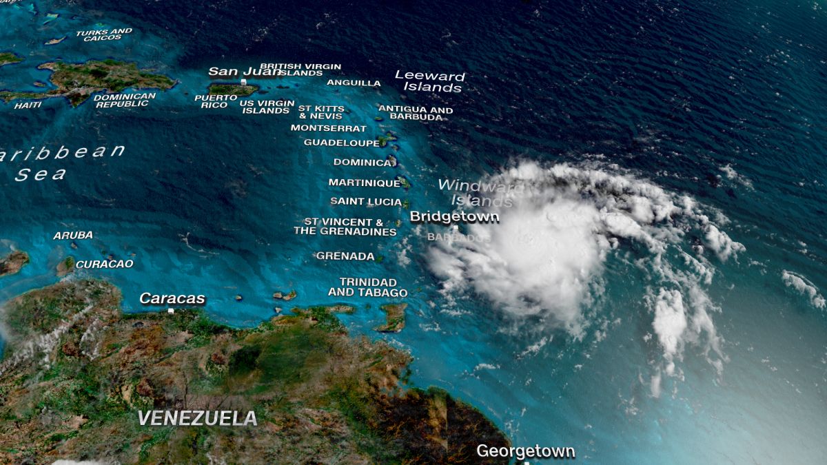
 La Tormenta Tropical Dorian se fortalece en el Atlántico acercándose a Puerto Rico y República Dominicana
Las aerolíneas continúan cancelando vuelos sobre la línea de actividad de la Tormenta Tropical Dorian de una extensión que abarca desde las Islas Barbados hasta República Dominicana en una franja de ancho sobre el paso de la tormenta de 250 kilómetros aproximadamente. La Tormenta Dorian podría fortalecerse si pasa por el Pasaje Mona entre Puerto Rico, a la derecha, y la República Dominicana a su izquierda.
Puerto Rico & Rep. Dominicana
Puerto Rico se prepara para fuertes lluvias a medida que se acerca la tormenta tropical Dorian. Se pronostica que Dorian estará cerca de la fuerza del huracán a medida que avanza hacia Puerto Rico y la República Dominicana. Ambos países se prepararon para la tormenta el Martes 27/08 mientras se agitaba hacia el oeste-noroeste, y las autoridades advirtieron que podría acercarse a la fuerza del huracán el Miércoles 28/08 después de soplar sobre Barbados. «Se pronostica un fortalecimiento lento durante las próximas 48 horas, y se pronostica que Dorian estará cerca de la fuerza del huracán cuando se acerque a Puerto Rico y al este de La Española», dijo en un informe el Centro Nacional de Huracanes (NHC) de Estados Unidos.
Se espera que el centro de la tormenta pase cerca o al sur de Puerto Rico el Miércoles 28/08, se mueva cerca o sobre el este de La Española, la isla que incluye a República Dominicana y la República de Haití, el Miércoles por la noche y se moverá al norte de La Española el Jueves 29/08. «Se esperan condiciones de tormenta tropical y es posible que haya huracanes en Puerto Rico el Miércoles y en partes de República Dominicana el Miércoles por la noche y el Jueves», dijo el CNH.
El gobernador de Puerto Rico, Wanda Vázquez Garced, declaró el estado de emergencia para el territorio de Estados Unidos a última hora del Lunes 26/08 en previsión de la tormenta, dijo el gobierno en Twitter.
Estados Unidos
Es una preocupación compartida por muchos en todo el territorio de los Estados Unidos donde unas 30.000 casas todavía tienen lonas azules como techos y donde los 3.2 millones de habitantes dependen de una red eléctrica inestable que Maria destruyó y sigue siendo propensa a cortes incluso en la más mínima tormenta.
Islas de Barlovento
Se esperaba que la tormenta arrojara entre ocho y 150 mm (tres a seis pulgadas) de lluvia en las Islas de Barlovento, con cantidades aisladas de 250 mm (10 pulgadas). Dorian ya causó cortes de energía y derribó árboles en Barbados y Santa Lucía, y una pista a largo plazo aún incierta mostró la tormenta cerca de Florida durante el fin de semana. «La amenaza de vientos y fuertes lluvias a finales de esta semana, hasta este fin de semana, en las Islas Turcas y Caicos, Bahamas y Florida está aumentando. Los residentes en estas áreas deben monitorear el progreso de Dorian y asegurarse de que tengan su plan de huracanes». dijo el NHC.
A fines del Martes 27/08 por la mañana, la tormenta se encontraba a unos 95 km (60 millas) al oeste-noroeste de Santa Lucía, soplando vientos máximos sostenidos de 50 millas por hora (85 km/h), según el NHC. Santa Lucía suspendió una advertencia de tormenta tropical para la isla.
Pronóstico de Tormenta Dorian
Para el Sábado 31/08, Dorian entrará en otra zona crítica llamada la Corriente del Golfo. La corriente del Golfo es un canal estrecho de aguas profundas y muy cálidas al este de Florida. Se sabe que tormentas como el huracán Andrew en 1992 y Katrina en 2005 se intensifican rápidamente en este tramo. Si bien no todas las tormentas se intensifican en la Corriente del Golfo, es un aspecto clave para determinar si Florida enfrentará una tormenta tropical debilitada o un huracán cada vez más fuerte en tierra.
Si bien es demasiado pronto para saber qué tan fuerte será la tormenta o dónde a lo largo de la costa este de Florida tocará tierra, los factores clave para vigilar en los próximos días son claros. El más importante de estos factores será evidente en breve a medida que la tormenta decida si viajará en el Pasaje de Mona. Si es así, ten cuidado.
Ahora es el momento de prepararse para la posibilidad de que un huracán toque tierra este fin de semana en algún lugar de la costa este de Florida. Eso significa refrescar su kit de seguridad contra huracanes en este momento.![]()
 Tropical Storm Dorian | 08/27
Tropical Storm Dorian strengthens in the Atlantic approaching Puerto Rico and the Dominican Republic
The airlines continue to cancel flights over the Dorian Tropical Storm activity line of an extension that spans from the Barbados Islands to the Dominican Republic in a wide strip over the storm passage of approximately 250 kilometers. Dorian Storm could be strengthened if you pass through the Mona Passage between Puerto Rico, on the right, and the Dominican Republic on your left.
Puerto Rico & Dominican
Puerto Rico prepares for heavy rains as tropical storm Dorian approaches. It is predicted that Dorian will be close to the force of the hurricane as it moves towards Puerto Rico and the Dominican Republic. Both countries prepared for the storm on Tuesday 27/08 as it stirred west-northwest, and authorities warned that it could approach the hurricane-force on Wednesday 28/08 after blowing on Barbados. «A slow strengthening is forecast for the next 48 hours, and it is predicted that Dorian will be close to the hurricane-force when it approaches Puerto Rico and east of La Española», the National Hurricane Center (NHC) said in a report. from the United States.
The center of the storm is expected to pass near or south of Puerto Rico on Wednesday 08/28, move near or east of Hispaniola, the island that includes the Dominican Republic and the Republic of Haiti, on Wednesday night and will move north of Hispaniola on Thursday 29/08. «Tropical storm conditions are expected and there may be hurricanes in Puerto Rico on Wednesday and in parts of the Dominican Republic on Wednesday night and Thursday», the CNH said.
The governor of Puerto Rico, Wanda Vázquez Garced, declared a state of emergency for the territory of the United States late on Monday 26/08 in anticipation of the storm, the government said on Twitter.
United States
It is a concern shared by many throughout the United States where some 30,000 houses still have blue tarpaulins as roofs and where the 3.2 million inhabitants depend on an unstable power grid that Maria destroyed and remains prone to cuts even in the most minimal storm.
Windward Islands
 The storm was expected to throw eight to 150 mm (three to six inches) of rain on the Windward Islands, with isolated amounts of 250 mm (10 inches). Dorian has already caused power outages and felled trees in Barbados and Saint Lucia, and a long-term track still uncertain showed the storm near Florida over the weekend. «The threat of winds and heavy rains later this week, until this weekend, in the Turks and Caicos Islands, the Bahamas and Florida is increasing. Residents in these areas should monitor Dorian’s progress and ensure they have their hurricane plan», said the NHC.
At the end of Tuesday 27/08 in the morning, the storm was about 95 km (60 miles) west-northwest of St. Lucia, blowing maximum sustained winds of 50 miles per hour (85 km/h), according to the NHC. St. Lucia suspended a tropical storm warning for the island.
Dorian Storm Forecast
By Saturday, Dorian will enter another critical area called the Gulf Stream. The Gulf Stream is a narrow channel of deep and very warm waters east of Florida. Storms such as Hurricane Andrew in 1992 and Katrina in 2005 are known to intensify rapidly on this stretch. While not all storms intensify in the Gulf Stream, it is a key aspect in determining whether Florida will face a weakened tropical storm or an increasingly strong hurricane on land.
While it is too early to know how strong the storm will be or where along the east coast of Florida it will land, the key factors to watch over the next few days are clear. The most important of these factors will be evident shortly as the storm decides whether to travel in the Mona Passage. If so, be careful.
Now is the time to prepare for the possibility of a hurricane hitting land this weekend somewhere on the east coast of Florida. That means refreshing your hurricane safety kit at this time. A \ W

Tormenta tropical Dorian Public Advisory
000
WTNT35 KNHC 280000 CCA
TCPAT5

BOLETÍN
Tormenta tropical Dorian Número de aviso intermedio 14A ... corregido
NWS National Hurricane Center Miami FL AL052019
800 PM AST Mar 27 Ago 2019

Nombre del pronosticador corregido

... DORIAN SE ENCUENTRA EN PUERTO RICO ...


RESUMEN DE 800 PM AST ... 0000 UTC ... INFORMACIÓN
----------------------------------------------
UBICACIÓN ... 15.8N 62.7W
ACERCA DE 300 MI ... 480 KM SE DE PONCE PUERTO RICO
VIENTOS MÁXIMOS SOSTENIDOS ... 50 MPH ... 85 KM / H
MOVIMIENTO ACTUAL ... WNW O 300 GRADOS A 13 MPH ... 20 KM / H
PRESIÓN CENTRAL MÍNIMA ... 1005 MB ... 29.68 PULGADAS


RELOJES Y ADVERTENCIAS
--------------------
CAMBIOS CON ESTA ADVERTENCIA:

El gobierno de la República Dominicana ha descontinuado el
Hurricane Watch de Isla Saona a Samana, y descontinuó el
Vigilancia de tormenta tropical desde Isla Saona hasta Punta Palenque.

RESUMEN DE RELOJES Y ADVERTENCIAS EN EFECTO:

Una alerta de huracán está vigente para ...
* Puerto Rico

Una advertencia de tormenta tropical está vigente para ...
* Puerto Rico
* Vieques
* Culebra
* Islas Vírgenes de EE.UU
* República Dominicana de Isla Saona a Samaná

Una vigilancia de tormenta tropical está vigente para ...
* República Dominicana de Samaná a Puerto Plata

Una alerta de huracán significa que las condiciones de huracán son posibles
dentro del área de vigilancia. Un reloj generalmente se emite 48 horas
antes de la primera aparición anticipada de fuerza de tormenta tropical
vientos, condiciones que dificultan los preparativos exteriores o
peligroso.

Una advertencia de tormenta tropical significa que las condiciones de tormenta tropical son
esperado en algún lugar dentro del área de advertencia dentro de las 36 horas.

Una vigilancia de tormenta tropical significa que las condiciones de tormenta tropical son
posible dentro del área de vigilancia, generalmente dentro de las 48 horas.

Para información sobre tormentas específica para su área en los Estados Unidos
Estados, incluidas posibles alertas y advertencias en el interior, por favor
monitorear productos emitidos por su Servicio Meteorológico Nacional local
oficina de previsión. Para información sobre tormentas específica de su área
fuera de los Estados Unidos, controle los productos emitidos por
Su servicio meteorológico nacional.


DISCUSIÓN Y PERSPECTIVAS
----------------------
A las 800 PM AST (0000 UTC), el centro de la tormenta tropical Dorian fue
ubicado cerca de un avión de la Unidad de Reserva de la Fuerza Aérea Hurricane Hunter cerca
latitud 15.8 norte, longitud 62.7 oeste. Dorian se está moviendo hacia
el oeste-noroeste cerca de 13 mph (20 km / h), y este movimiento es
se espera que continúe esta noche, seguido de un giro hacia el
noroeste el miércoles. En la pista del pronóstico, el centro de Dorian
se moverá a través del noreste del Mar Caribe esta noche, pase
o cerca del oeste y centro de Puerto Rico el miércoles, y muévete cerca
o justo al este de la Española el miércoles por la noche. El jueves
noche y viernes, se pronostica que el centro de Dorian se moverá cerca o
al este de las Islas Turcas y Caicos y el sureste de Bahamas.

Los vientos máximos sostenidos permanecen cerca de 50 mph (85 km / h) con mayor
ráfagas Se pronostica un fortalecimiento lento durante las próximas 24 horas, y
Se pronostica que Dorian estará cerca de la fuerza del huracán cuando se acerque
Puerto Rico el miércoles. Se espera cierto debilitamiento después de Dorian
se mueve a través del terreno más alto de Puerto Rico el miércoles por la noche.
Se espera que Dorian se fortalezca gradualmente los jueves y viernes.
mientras pasa cerca o al este de las Islas Turcas y Caicos y
Sureste de Bahamas.

Los vientos con fuerza de tormenta tropical se extienden hacia afuera hasta 45 millas (75 km)
del centro

La presión central mínima reportada por el huracán Hunter
la aeronave es de 1005 mb (29.68 pulgadas).


PELIGROS QUE AFECTAN LA TIERRA
----------------------
LLUVIA: Se espera que Dorian produzca la siguiente lluvia
acumulaciones:

Guadalupe a Dominica ... 1 a 4 pulgadas.
Puerto Rico y República Dominicana ... 4 a 6 pulgadas, aislado 8
pulgadas.
Islas Vírgenes y Haití ... 1 a 3 pulgadas, aisladas 4 pulgadas.
Bahamas ... 2 a 4 pulgadas.
Florida ... 3 a 5 pulgadas, aislado 7 pulgadas.

Esta lluvia puede causar inundaciones repentinas que amenazan la vida.

VIENTO: Se esperan condiciones de tormenta tropical y huracán
las condiciones son posibles en Puerto Rico el miércoles. Tropical
se esperan condiciones de tormenta en las Islas Vírgenes de EE. UU.
Miércoles. Se esperan condiciones de tormenta tropical en partes de
República Dominicana a última hora del miércoles y jueves.

SURF: las olas generadas por Dorian deberían desaparecer gradualmente en el
Antillas Menores esta noche. Se espera que las olas aumenten
a lo largo de las costas del sur de Puerto Rico y La Española el miércoles
y podrían causar corrientes de resaca y olas que amenazan la vida
condiciones Consulte los productos de su oficina meteorológica local.


PRÓXIMA ADVERTENCIA
-------------
Siguiente aviso completo a las 11:00 PM AST.

$$
Pronosticador Pasch
Tropical Storm Dorian Public Advisory
WTNT35 KNHC 280000 CCA
TCPAT5

BULLETIN
Tropical Storm Dorian Intermediate Advisory Number 14A...Corrected
NWS National Hurricane Center Miami FL       AL052019
800 PM AST Tue Aug 27 2019

Corrected forecaster name

...DORIAN HEADING FOR PUERTO RICO...


SUMMARY OF 800 PM AST...0000 UTC...INFORMATION
----------------------------------------------
LOCATION...15.8N 62.7W
ABOUT 300 MI...480 KM SE OF PONCE PUERTO RICO
MAXIMUM SUSTAINED WINDS...50 MPH...85 KM/H
PRESENT MOVEMENT...WNW OR 300 DEGREES AT 13 MPH...20 KM/H
MINIMUM CENTRAL PRESSURE...1005 MB...29.68 INCHES


WATCHES AND WARNINGS
--------------------
CHANGES WITH THIS ADVISORY:

The government of the Dominican Republic has discontinued the
Hurricane Watch from Isla Saona to Samana, and discontinued the
Tropical Storm Watch from Isla Saona to Punta Palenque.

SUMMARY OF WATCHES AND WARNINGS IN EFFECT:

A Hurricane Watch is in effect for...
* Puerto Rico

A Tropical Storm Warning is in effect for...
* Puerto Rico
* Vieques
* Culebra
* U.S. Virgin Islands
* Dominican Republic from Isla Saona to Samana

A Tropical Storm Watch is in effect for...
* Dominican Republic from Samana to Puerto Plata

A Hurricane Watch means that hurricane conditions are possible
within the watch area.  A watch is typically issued 48 hours
before the anticipated first occurrence of tropical-storm-force
winds, conditions that make outside preparations difficult or
dangerous.

A Tropical Storm Warning means that tropical storm conditions are
expected somewhere within the warning area within 36 hours.

A Tropical Storm Watch means that tropical storm conditions are
possible within the watch area, generally within 48 hours.

For storm information specific to your area in the United
States, including possible inland watches and warnings, please
monitor products issued by your local National Weather Service
forecast office. For storm information specific to your area
outside of the United States, please monitor products issued by
your national meteorological service.


DISCUSSION AND OUTLOOK
----------------------
At 800 PM AST (0000 UTC), the center of Tropical Storm Dorian was
located by an Air Force Reserve Unit Hurricane Hunter aircraft near
latitude 15.8 North, longitude 62.7 West.  Dorian is moving toward
the west-northwest near 13 mph (20 km/h), and this motion is
expected to continue through tonight, followed by a turn toward the
northwest on Wednesday.  On the forecast track, the center of Dorian
will move across the northeastern Caribbean Sea tonight, pass over
or near western and central Puerto Rico on Wednesday, and move near
or just east of eastern Hispaniola Wednesday night.  On Thursday
night and Friday, the center of Dorian is forecast to move near or
to the east of the Turks and Caicos and the southeastern Bahamas.

Maximum sustained winds remain near 50 mph (85 km/h) with higher
gusts.  Slow strengthening is forecast during the next 24 hours, and
Dorian is forecast to be near hurricane strength when it approaches
Puerto Rico on Wednesday.  Some weakening is expected after Dorian
moves across the higher terrain of Puerto Rico Wednesday night.
Dorian is expected to gradually re-strengthen on Thursday and Friday
while passing near or to the east of the Turks and Caicos and
southeastern Bahamas.

Tropical-storm-force winds extend outward up to 45 miles (75 km)
from the center.

The minimum central pressure reported by the Hurricane Hunter
aircraft is 1005 mb (29.68 inches).


HAZARDS AFFECTING LAND
----------------------
RAINFALL:  Dorian is expected to produce the following rainfall
accumulations:

Guadeloupe to Dominica...1 to 4 inches.
Puerto Rico and Dominican Republic...4 to 6 inches, isolated 8
inches.
Virgin Islands and Haiti...1 to 3 inches, isolated 4 inches.
Bahamas...2 to 4 inches.
Florida...3 to 5 inches, isolated 7 inches.

This rainfall may cause life-threatening flash floods.

WIND:  Tropical storm conditions are expected and hurricane
conditions are possible in Puerto Rico on Wednesday.  Tropical
storm conditions are expected in the U.S. Virgin Islands on
Wednesday.  Tropical storm conditions are expected in portions of
the Dominican Republic late Wednesday and Thursday.

SURF:  Swells generated by Dorian should gradually subside in the
Lesser Antilles tonight. Swells are expected to increase
along the southern coasts of Puerto Rico and Hispaniola on Wednesday
and they could cause life-threatening surf and rip current
conditions.  Please consult products from your local weather office.


NEXT ADVISORY
-------------
Next complete advisory at 1100 PM AST.

$$
Forecaster Pasch
![]()
HURRICANE SAFETY CHECKLIST
 REDCROSS https://www.redcross.org/content/dam/redcross/atg/PDF_s/Preparedness___Disaster_Recovery/Disaster_Preparedness/Hurricane/Hurricane.pdf
Ξ A I R G W A Y S Ξ
SOURCE: Airgways.com
DBk: Noaa.gov / Cbsnews.com / Theguardian.com / Anu.edu.au / Cnn..com / Airgways.com / Redcross.org
AW-POST: 201908272201AR
A\W A I R G W A Y S ®
 AW | 2019 08 27 21:26 | INDUSTRY / AIRLINES
 Take off first A350-900 Air France
 AW | 2019 08 27 20:57 | AVIATION SAFETY / INDUSTRY
 Boeing faces 1st demand for 737 MAX
 Russian leasing services company Avia Capital Services, a subsidiary of Russian state conglomerate Rostec, issuing The Boeing Company, alleging breach of contract in relation to its Boeing 737 MAX becoming the first lawsuit filed against the manufacturer by a client due to the security crisis, due to the air accidents that preceded the grounding of the 737 MAX were due to «negligent actions and decisions of Boeing». Avia claims that Boeing not only designed a defective aircraft but also retained critical information from the U.S. FAA air safety regulator during certification.
 The complaint, which was filed at the Cook County Circuit Court in Chicago on Monday, August 26, 2019, states that Boeing intentionally did not disclose information about the airworthiness of 737 MAX to its customers, including Avia, to induce them to buy the plane.
 AW | 2019 08 27 20:21 | AIRLINES
 ARJ-21完成測試在大興機場
 AW | 2019 08 27 15:17 | AIRLINES
 The return of Eastern Airlines
 Lines and formed the Eastern Air Lines Group. The group announced in early 2014 that it had submitted an application to the U.S. Department of Transportation (DOT) to obtain a Certificate of Convenience and Public Necessity, which will be followed by a certification with the Federal Aviation Administration (FAA). The new airline began providing services through charter flights and wet leases from Miami International at the end of 2014 with Boeing 737-800 planes painted with the Eastern Air Lines «hockey stick» livery. The IATA and ICAO codes of the classic Eastern Air lines, as well as their callsign, are now used by the new iteration of Eastern Air Lines. After-sale to Swift Air. Registered trademarks were passed to Eastern Airlines LLC in 2018.
 AW | 2019 08 27 14:24 | AIRLINES / AIRLINES MARKET
 Passaredo Linhas Aéreas complementará la red de servicios con MAP Linhas Aéreas
 órgano, Roselene Medeiros, y el ex Vicepresidente de MAP, Marcos Fernandes Pacheco. anunciando que MAP Linhas Aéreas conservará su imagen corporativa y aumentará su presencia en el Norte de Brasil. La adquisición de la compañía proporciona una mejor red de servicios regionales.
 Passaredo-MAP expands presence in Brazil
 Passaredo-MAP amplia presença no Brasil
 MAP Linhas Aéreas
 AW | 2019 08 27 12:35 | AIRLINES MARKET / AIRLINES ROUTES
 Greater low-cost presence to Brazil
 Maior presença de baixo custo no Brasil
 AW | 2019 08 27 11:42 | AIRLINES ROUTES
 Latam Argentina continues to Miami
 AW | 2019 08 27 11:22 | AIRLINES / GOVERNMENT
 Demands for the control of Avianca
 AW | 2019 08 27 11:00 | AIRPORTS / GOVERNMENT
 El Palomar stops night flights