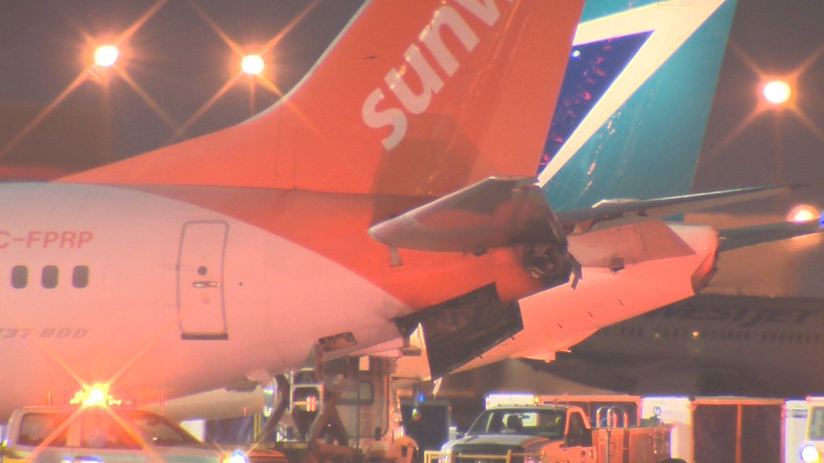
Ciclón Berguitta disminuye impacto

AW | 2018 01 18 14:51 | AVIATION SAFETY

La isla de Mauricio está cruzando el impacto del ciclón Berguitta en dirección a la isla Reunión con fuertes vientos y lluvias

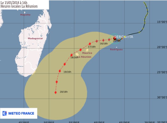
El Ciclón Berguitta se perdió anoche la costa sureste de la Isla Mauricio. «Parece que el ojo del ciclón Berguitta acaba de pasar por alto la costa sudeste de Mauricio», informa el parte meteorológico. El centro del ciclón estaba a unas 220 millas al sureste de Mauricio el 17 de enero, con vientos máximos de 90 millas por hora, según los informes. Se pronostica que ha pasado directamente sobre Mauricio este 18 de Enero, pero el popular destino turístico parece haber sobrevivido a un ataque directo potencialmente mortal.

¿Dónde está Cyclone Berguitta ahora?

Según el sistema de seguimiento meteorológico Cycolcane, el ciclón tropical Berguitta ha pasado por el extremo sudeste de Mauricio. La tormenta, que ahora registra vientos de 55 mph, incluso ha pasado por La Reunión, que barrió la costa sur. Justo antes de las 11 a.m. GMT, Met Office tuiteó: «La tormenta tropical Berguitta ahora pasa justo al sur de La Reunión. «Más de 200 mm de lluvia en 24 horas informaron en muchos lugares con un pico de 645 mm (25,4″) en un sitio elevado». Las velocidades máximas pronosticadas del viento alcanzarán máximas de 65 nudos, 75 mph el viernes a las 6 a.m.

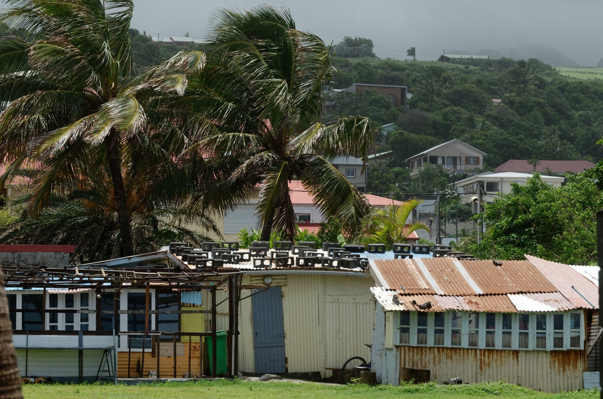
A pesar de evitar un impacto directo de la tormenta sobre la Isla Mauricio fue golpeada por los fuertes vientos de la noche anterior, sufriendo altos niveles de daños a medida que la tormenta pasaba a lo largo de la costa. El meteorólogo Philip Klotzbach dijo que Berguitta golpeó la isla como el equivalente a un huracán de categoría 1 después de que comenzó a alejarse de Mauricio durante la noche. El ciclón tropical Berguitta está empezando a presionar a Mauricio. Se ha debilitado lentamente en los últimos días, pero aún se estima que tiene vientos máximos de 75 mph.

El principal aeropuerto de Mauricio canceló todos los vuelos antes de la tormenta y el puerto principal se ha cerrado. Se recomienda a los habitantes de Mauricio y La Reunión, también conocidos como La Reunión, que tomen todas las precauciones y se mantengan a salvo. El ciclón Berguitta se perdió anoche (miércoles) la costa sureste de la zona de la Isla Mauricio.

Berguitta rumbo a La Reunión

Berguitta ya no es un ciclón, sino que sigue siendo una «tormenta tropical fuerte». Después de llegar a Mauricio esta mañana, se acercará a Reunión en la tarde o al final de la tarde, el jueves 18 de Enero de 2018.

El huracán Berguitta, que golpeó a Isla Mauricio, y la Isla La Reunión este jueves 18, ha perdido el poder hasta el punto de ser reclasificado como «fuerte tormenta tropical». Sin embargo, el departamento sigue vigilante la alerta naranja, especialmente a causa del deterioro de las condiciones climáticas y los fenómenos peligrosos que induce. Después de llegar a Mauricio por la mañana, la tormenta pasará tan cerca de Reunión en la tarde o en la tarde del jueves 18 de enero, según la reunión de Meteo France en un comunicado de prensa.

Como lo explica Meteo-France en su comunicado de prensa, el centro de la formación tropical está a unas pocas decenas de kilómetros de Saint-Philippe. Este acercamiento va acompañado de un deterioro de las condiciones climáticas, con episodios lluvioso y ventoso por lo tanto. Cabe señalar que estas condiciones climáticas no son excepcionales para la isla. El departamento, sin embargo, permanece en una situación de alerta naranja. AIRWAYS® AW-Icon TXT


Cyclone Berguitta avoids direct impact in Mauritius

The Island of Mauritius is crossing the impact of the Cyclone Berguitta heading towards Reunion Island with strong winds and rainfall

Cyclone Berguitta was lost last night on the southeast coast of Mauritius. «It seems that the eye of cyclone Berguitta has just missed the south-east coast of Mauritius,» the weather report reports. The center of the cyclone was about 220 miles southeast of Mauritius on January 17, with maximum winds of 90 miles per hour, according to reports. It is predicted that it has passed directly to Mauritius on January 18, but the popular tourist destination seems to have survived a direct, life-threatening attack.

Where is Cyclone Berguitta now?

According to the Cycolcane weather monitoring system, tropical cyclone Berguitta has passed through the southeastern tip of Mauritius. The storm, which now records winds of 55 mph, has even passed through La Réunion, which swept the southern coast. Just before 11 a.m. GMT, Met Office tweeted: «Tropical storm Berguitta now passes just south of La Réunion. More than 200 mm of rain in 24 hours reported in many places with a peak of 645 mm (25.4 ) at an elevated site.« The maximum predicted wind speeds will reach a maximum of 65 knots, 75 mph on Friday at 6 a.m. M.

Despite avoiding a direct impact of the storm on Mauritius Island was hit by the strong winds of the previous night, suffering high levels of damage as the storm passed along the coast. Meteorologist Philip Klotzbach said that Berguitta hit the island as the equivalent of a Category 1 hurricane after it started to move away from Mauritius during the night. Tropical cyclone Berguitta is starting to put pressure on Mauritius, but it has slowly weakened in recent days, but it is still estimated to have maximum winds of 75 mph.

The main airport in Mauritius canceled all flights before the storm and the main port has been closed. It is recommended that the inhabitants of Mauritius and La Reunion, also known as La Reunion, take all precautions and stay safe. Cyclone Berguitta was lost last night (Wednesday) the southeastern coast of the Mauritius area.

Berguitta bound for La Réunion

Berguitta is no longer a cyclone, but remains a «strong tropical storm». After arriving in Mauritius this morning, you will approach Reunion in the afternoon or late afternoon, on Thursday, January 18, 2018.

Hurricane Berguitta, which hit Mauritius, and Reunion Island on Thursday, 18, has lost power to the point of being reclassified as a «strong tropical storm». However, the department remains vigilant in the orange alert, especially because of the deterioration of weather conditions and the dangerous phenomena it induces. After arriving in Mauritius in the morning, the storm will pass so close to Reunion in the afternoon or afternoon of Thursday, January 18, according to the Meteo France meeting in a press release.

As Meteo-France explains in its press release, the center of the tropical formation is a few tens of kilometers from Saint-Philippe. This approach is accompanied by a deterioration of weather conditions, with rainy and windy episodes therefore. It should be noted that these climatic conditions are not exceptional for the island.The department, however, remains in an orange alert situation. A \ W


Ξ A I R G W A Y S Ξ
SOURCE:  Airgways.com
DBk: Nasa.gov / Meteo-reunion.com / Meteofrance.re / Twitter.com [Préfet de La Réunion]
AW-POST: 201801181451AR

A\W   A I R G W A Y S ®

Isla Mauricio en alerta máxima a Cat-4 por Ciclón Berguitta

AW | 2018 01 17 21:10 | AVIATION SAFETY

1f300La Isla Mauricio se está preparando para la llegada del Ciclón tropical Berguitta

Los fuertes vientos que podrían producir ráfagas de hasta 120 km por hora ya se dejan sentir en la Categoría 3 del Ciclón Berguitta.

Miles de residentes se han congregado en los refugios del Gobierno de la isla contra tormentas. Pravind Ruggoo del Centro Nacional de Gestión y Reducción del Riesgo de Desastres informa: «La población no debería entrar en áreas de riesgo, áreas donde hay derrumbes, acumulaciones de agua y también áreas propensas a inundaciones». Muchos residentes temen que Berguitta cause un daño extenso cuando toque tierra debido a la hora local del mediodía del jueves antes de que llegue a su vecino más cercano, la Isla Reunión. Los productores de vegetales de las islas ya han informado que sus campos se han inundado y se dice que alrededor de 300 hogares carecen de electricidad.

La Isla Mauricio permanece en alerta máxima ante el avance del Ciclón Berguitta. El Gobierno de la isla comunica a la población permanecer en lugares seguros. Los servicios de emergencia están en alerta con el cierre del aeropuerto y el puerto. Desde esta mañana, Mauricio está algo aislada del mundo.

Efecto ciclón en Air Mauritius

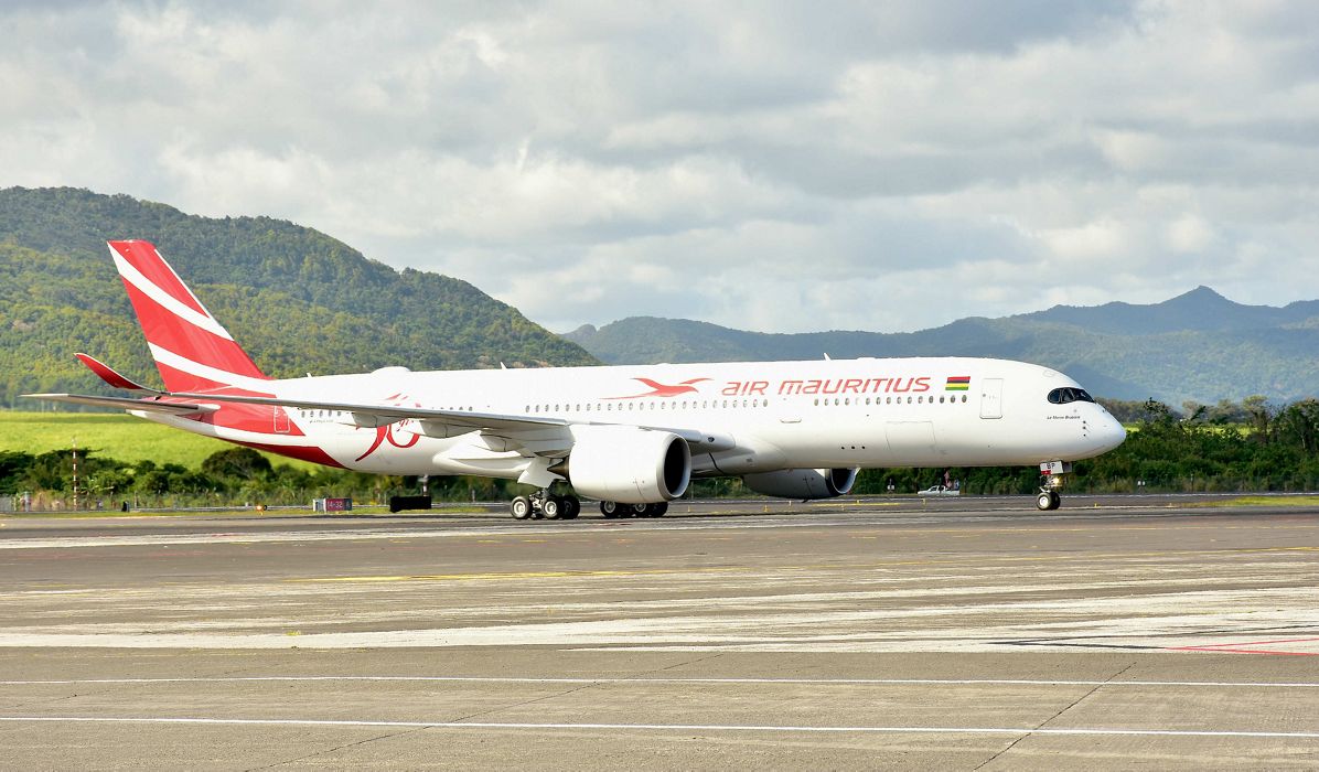
Imagen relacionadaPara la aerolínea de la isla, Air Mauritius las consecuencias podrían sacudir las arcas. El lunes 15 de Enero, cinco vuelos que partían hacia Isla Rodrigues fueron cancelados. Al día siguiente, se pospusieron diez vuelos, que aún parten hacia el mismo destino. El miércoles 17 de Enero, con la transición a la Clase de Advertencia de Ciclón 3, todos los vuelos fueron cancelados. Entre ellos, más de veinte vuelos de Air Mauritius.

Estas cancelaciones conllevan costos. Air Mauritius sostiene que aún es demasiado pronto para estimar los gastos incurridos. Sin embargo, una fuente cercana a este entorno indica que teniendo en cuenta el hecho de que un Airbus A340 tiene alrededor de 300 asientos y que el ATR 72 tiene setenta asientos, estiman las pérdidas en alrededor de Ꞧs 30 millones de rupias a Ꞧs 35 millones de rupias está justificado. Sin embargo, señalan desde la compañía que se están ahorrando en el costo del combustible y las bebidas en los vuelos.

Varios pasajeros señalan en particular que no ha habido comunicación de Air Mauritius sobre la evolución de la situación, aunque desde la aerolínea sostienen que han emitidos boletines regularmente. Tratamos de mantenernos en contacto con los pasajeros individualmente, sostiene Air Mauritius. Se dice que la información también está disponible en el sitio web www.airmauritius.com. Los pasajeros también pueden solicitar una actualización de la situación mediante el envío de un SMS al 5 259 90 90. «Si los pasajeros quieren cambiar su plan de vuelo o cancelar su viaje, pueden hacerlo de forma gratuita, especialmente durante los próximos dos días», informan desde la aerolínea. AIRWAYS® AW-Icon TXT

Mauritius maximum alert to Cat-4 by Cyclone Berguitta

Mauritius is preparing for the arrival of the Tropical Cyclone Berguitta

The strong winds that could produce gusts of up to 120 km per hour are already felt in Category 3 of the Cyclone Berguitta.

Thousands of residents have gathered in island government shelters against storms. Pravind Ruggoo of the National Center for Management and Disaster Risk Reduction reports: «The population should not enter risk areas, areas where there are landslides, water accumulations and also areas prone to flooding». Many residents fear that Berguitta will cause extensive damage when it makes landfall due to Thursday’s noon local time before it reaches its closest neighbor, Reunion Island. The vegetable producers of the islands have already reported that their fields have been flooded and it is said that around 300 households lack electricity.

Cyclone Berguitta.png

Mauritius Island remains on high alert before the advance of Cyclone Berguitta. The Government of the island communicates to the population to remain in safe places. The emergency services are on alert with the closure of the airport and the port. Since this morning, Mauricio is somewhat isolated from the world.

Resultado de imagen para Air Mauritius A350 png

Cyclone effect in Air Mauritius

For the airline of the island, Air Mauritius the consequences could shake the coffers. On Monday, January 15, five flights departing for Rodrigues Island were canceled. The next day, ten flights were postponed, leaving for the same destination. On Wednesday, January 17, with the transition to Cyclone Warning Class 3, all flights were canceled. Among them, more than twenty Air Mauritius flights.

These cancellations entail costs. Air Mauritius maintains that it is still too early to estimate the expenses incurred. However, a source close to this environment indicates that taking into account the fact that an Airbus A340 has about 300 seats and that the ATR 72 has seventy seats, they estimate the losses at around Ꞧs 30 million rupees to Ꞧs 35 million of rupees is justified. However, they point out from the company that they are saving on the cost of fuel and drinks on flights.

Several passengers point out in particular that there has been no communication from Air Mauritius about the evolution of the situation, although from the airline they maintain that they have issued bulletins regularly. We try to keep in touch with passengers individually, says Air Mauritius. It is said that the information is also available on the website www.airmauritius.com. Passengers can also request an update of the situation by sending an SMS to 5 259 90 90. «If passengers want to change their flight plan or cancel their trip, they can do it for free, especially during the next two days», report from the airline. A \ W


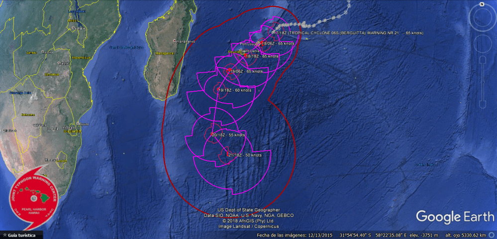
 Joint Typhoon Warning Center (JTWC)

WTXS31 PGTW 172100
MSGID/GENADMIN/JOINT TYPHOON WRNCEN PEARL HARBOR HI//
SUBJ/TROPICAL CYCLONE 06S (BERGUITTA) WARNING NR 021//
RMKS/
1. TROPICAL CYCLONE 06S (BERGUITTA) WARNING NR 021
01 ACTIVE TROPICAL CYCLONE IN SOUTHIO
MAX SUSTAINED WINDS BASED ON ONE-MINUTE AVERAGE
WIND RADII VALID OVER OPEN WATER ONLY
—
WARNING POSITION:
171800Z — NEAR 18.9S 59.5E
MOVEMENT PAST SIX HOURS – 225 DEGREES AT 06 KTS
POSITION ACCURATE TO WITHIN 030 NM
POSITION BASED ON CENTER LOCATED BY SATELLITE
PRESENT WIND DISTRIBUTION:
MAX SUSTAINED WINDS – 065 KT, GUSTS 080 KT
WIND RADII VALID OVER OPEN WATER ONLY
RADIUS OF 050 KT WINDS – 070 NM NORTHEAST QUADRANT
065 NM SOUTHEAST QUADRANT
040 NM SOUTHWEST QUADRANT
040 NM NORTHWEST QUADRANT
RADIUS OF 034 KT WINDS – 110 NM NORTHEAST QUADRANT
170 NM SOUTHEAST QUADRANT
165 NM SOUTHWEST QUADRANT
090 NM NORTHWEST QUADRANT
REPEAT POSIT: 18.9S 59.5E
—
FORECASTS:
12 HRS, VALID AT:
180600Z — 20.1S 58.0E
MAX SUSTAINED WINDS – 065 KT, GUSTS 080 KT
WIND RADII VALID OVER OPEN WATER ONLY
RADIUS OF 064 KT WINDS – 000 NM NORTHEAST QUADRANT
025 NM SOUTHEAST QUADRANT
000 NM SOUTHWEST QUADRANT
000 NM NORTHWEST QUADRANT
RADIUS OF 050 KT WINDS – 030 NM NORTHEAST QUADRANT
065 NM SOUTHEAST QUADRANT
035 NM SOUTHWEST QUADRANT
025 NM NORTHWEST QUADRANT
RADIUS OF 034 KT WINDS – 120 NM NORTHEAST QUADRANT
210 NM SOUTHEAST QUADRANT
205 NM SOUTHWEST QUADRANT
085 NM NORTHWEST QUADRANT
VECTOR TO 24 HR POSIT: 235 DEG/ 12 KTS
—
24 HRS, VALID AT:
181800Z — 21.5S 56.0E
MAX SUSTAINED WINDS – 065 KT, GUSTS 080 KT
WIND RADII VALID OVER OPEN WATER ONLY
RADIUS OF 064 KT WINDS – 000 NM NORTHEAST QUADRANT
020 NM SOUTHEAST QUADRANT
010 NM SOUTHWEST QUADRANT
010 NM NORTHWEST QUADRANT
RADIUS OF 050 KT WINDS – 040 NM NORTHEAST QUADRANT
075 NM SOUTHEAST QUADRANT
055 NM SOUTHWEST QUADRANT
035 NM NORTHWEST QUADRANT
RADIUS OF 034 KT WINDS – 105 NM NORTHEAST QUADRANT
225 NM SOUTHEAST QUADRANT
210 NM SOUTHWEST QUADRANT
095 NM NORTHWEST QUADRANT
VECTOR TO 36 HR POSIT: 230 DEG/ 12 KTS
—
36 HRS, VALID AT:
190600Z — 23.1S 54.0E
MAX SUSTAINED WINDS – 065 KT, GUSTS 080 KT
WIND RADII VALID OVER OPEN WATER ONLY
RADIUS OF 064 KT WINDS – 005 NM NORTHEAST QUADRANT
025 NM SOUTHEAST QUADRANT
025 NM SOUTHWEST QUADRANT
015 NM NORTHWEST QUADRANT
RADIUS OF 050 KT WINDS – 045 NM NORTHEAST QUADRANT
065 NM SOUTHEAST QUADRANT
045 NM SOUTHWEST QUADRANT
040 NM NORTHWEST QUADRANT
RADIUS OF 034 KT WINDS – 120 NM NORTHEAST QUADRANT
255 NM SOUTHEAST QUADRANT
225 NM SOUTHWEST QUADRANT
100 NM NORTHWEST QUADRANT
VECTOR TO 48 HR POSIT: 215 DEG/ 12 KTS
—
EXTENDED OUTLOOK:
48 HRS, VALID AT:
191800Z — 25.1S 52.4E
MAX SUSTAINED WINDS – 060 KT, GUSTS 075 KT
WIND RADII VALID OVER OPEN WATER ONLY
RADIUS OF 050 KT WINDS – 045 NM NORTHEAST QUADRANT
065 NM SOUTHEAST QUADRANT
035 NM SOUTHWEST QUADRANT
030 NM NORTHWEST QUADRANT
RADIUS OF 034 KT WINDS – 145 NM NORTHEAST QUADRANT
245 NM SOUTHEAST QUADRANT
215 NM SOUTHWEST QUADRANT
095 NM NORTHWEST QUADRANT
VECTOR TO 72 HR POSIT: 195 DEG/ 13 KTS
—
72 HRS, VALID AT:
201800Z — 30.0S 51.1E
MAX SUSTAINED WINDS – 055 KT, GUSTS 070 KT
WIND RADII VALID OVER OPEN WATER ONLY
BECOMING EXTRATROPICAL
RADIUS OF 050 KT WINDS – 070 NM NORTHEAST QUADRANT
065 NM SOUTHEAST QUADRANT
055 NM SOUTHWEST QUADRANT
045 NM NORTHWEST QUADRANT
RADIUS OF 034 KT WINDS – 175 NM NORTHEAST QUADRANT
225 NM SOUTHEAST QUADRANT
185 NM SOUTHWEST QUADRANT
135 NM NORTHWEST QUADRANT
VECTOR TO 96 HR POSIT: 145 DEG/ 07 KTS
—
LONG RANGE OUTLOOK:
—
96 HRS, VALID AT:
211800Z — 32.4S 53.0E
MAX SUSTAINED WINDS – 050 KT, GUSTS 065 KT
WIND RADII VALID OVER OPEN WATER ONLY
EXTRATROPICAL
RADIUS OF 050 KT WINDS – 020 NM NORTHEAST QUADRANT
050 NM SOUTHEAST QUADRANT
070 NM SOUTHWEST QUADRANT
050 NM NORTHWEST QUADRANT
RADIUS OF 034 KT WINDS – 160 NM NORTHEAST QUADRANT
280 NM SOUTHEAST QUADRANT
240 NM SOUTHWEST QUADRANT
170 NM NORTHWEST QUADRANT
—
REMARKS:
172100Z POSITION NEAR 19.2S 59.1E.
TROPICAL CYCLONE 06S (BERGUITTA), LOCATED APPROXIMATELY 144 NM
EAST-NORTHEAST OF PORT LOUIS, MAURITIUS, HAS TRACKED SOUTHWESTWARD
AT 06 KNOTS OVER THE PAST SIX HOURS. RECENT ANIMATED MULTISPECTRAL
SATELLITE IMAGERY SHOWS A SHIELD OF RELATIVELY DISORGANIZED DEEP
CONVECTION PERSISTING OVER A LOW-LEVEL CIRCULATION CENTER EVIDENT IN
A 171715Z METOP-B ASCAT PASS AND A 1758Z METOP-A ASCAT PASS. THE
CURRENT POSITION IS BASED ON THESE ASCAT PASSES, WITH HIGH
CONFIDENCE. THE INTENSITY OF 65 KNOTS IS CONSISTENT WITH RECENT
MULTI-AGENCY DVORAK AND AUTOMATED SATELLITE INTENSITY CONSENSUS
ESTIMATES. TC 06S IS TURNING POLEWARD UNDER THE STEERING INFLUENCE
OF A REORIENTING SUBTROPICAL RIDGE SITUATED TO THE SOUTHEAST. THE
SYSTEM IS EXPECTED TO CONTINUE TRACKING AROUND THE RIDGE AXIS DURING
THE FORECAST PERIOD, BEGINNING EXTRATROPICAL TRANSITION BY TAU 72
AND COMPLETING BY TAU 96. INTENSITY IS EXPECTED TO REMAIN RELATIVELY
STEADY OVER THE NEXT 36 HOURS AS FAVORABLE POLEWARD OUTFLOW AND
UNFAVORABLE, MODERATE EASTERLY VERTICAL WIND SHEAR EXERT COMPETING
INFLUENCES. MARGINAL WEAKENING IS ANTICIPATED IN THE MEDIUM TO
EXTENDED-RANGE AS THE TC 06S TRACKS OVER COOLER WATER AND ENCOUNTERS
INCREASING VERTICAL WIND SHEAR, BUT RECEIVES OFFSETTING BAROCLINIC
SUPPORT AS IT UNDERGOES EXTRATROPICAL TRANSITION. THE CURRENT, HIGH-
CONFIDENCE FORECAST TRACK IS CONSISTENT WITH CONSENSUS MODEL
TRACKERS, WHICH REMAIN IN TIGHT AGREEMENT. MAXIMUM SIGNIFICANT WAVE
HEIGHT AT 171800Z IS 25 FEET. NEXT WARNINGS AT 180300Z, 180900Z,
181500Z AND 182100Z.//

SOURCE >  ww.usno.navy.mil/NOOC/nmfc-ph/RSS/jtwc/warnings/sh0618web.txt


Ξ A I R G W A Y S Ξ
SOURCE:  Airgways.com
DBk: Airmauritius.com / Bloomberg.com / Airbus.com / Nrlmry.navy.mil / Ssd.noaa.gov / Usno.navy.mil/JTWC / Google Earth Pro
AW-POST: 201801172110AR

A\W   A I R G W A Y S ®

Isla Reunión alerta por Ciclón Berguitta

AW | 2018 01 17 19:52 | AVIATION SAFETY

1f300Alerta naranja por Ciclón Berguitta podría afectar la Isla Reunión

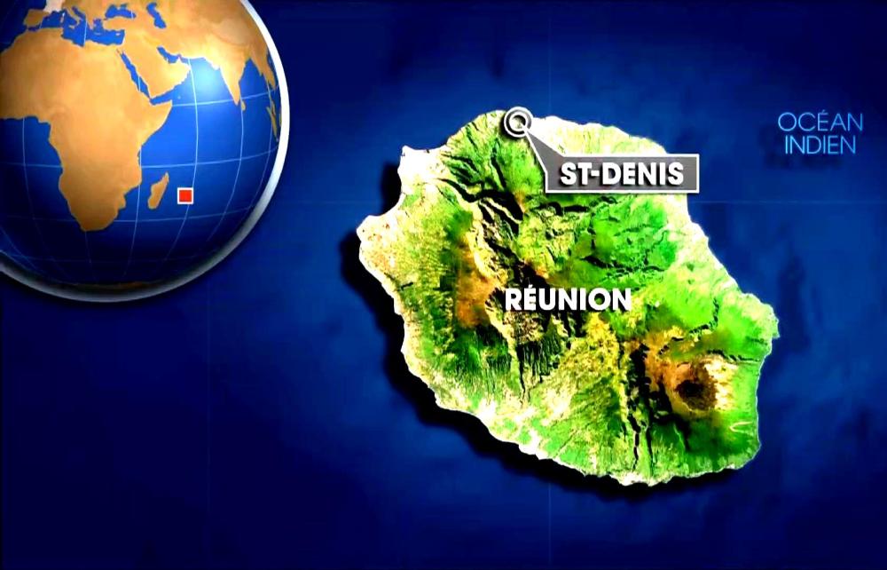
El Aeropuerto Internacional Roland Garros ubicado a 7 kilómetros de Saint-Denis en la Isla Reunión ha sido cerrado por precaución ante el avance del Ciclón Berguita.

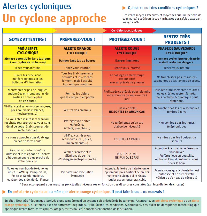
La Isla de la Reunión fue puesta en alerta naranja el miércoles por la mañana, según la prefectura de la isla, a medida que se aproxima la tormenta tropical Berguitta. El ciclón degradado a una «tormenta tropical» se ubicó a poco menos de 500 km al noreste de Reunión. Se espera su paso más cerca de la isla en el día del jueves. «La inflexión de la trayectoria hacia el sudoeste comenzó, acercando más directamente el fenómeno de Mauricio, luego a la Isla Reunión», dijo un comunicado de Météo-France Réunion.

El prefecto de Reunión ha decidido activar el nivel de naranja del dispositivo específico Ciclones ORSEC desde las 08:00 a.m. Desde el lunes la isla estaba en alerta pre-ciclónica. «Anticipación y precaución están a la orden del día», dijo la ministra de ultramar Annick Girardin, que visitó la tarde del miércoles en el Centro Operacional Interdepartamental de Gestión de Crisis (COGIC), donde el fenómeno se monitorea de cerca.

El ministro, que habló por videoconferencia con el prefecto de Reunión, dijo que según las últimas proyecciones, la fuerte tormenta tropical «pasaría por Reunion, en la costa sudeste, con consecuencias en materia de precipitaciones y vientos».

La evolución del Ciclón Berguitta podría ir modificándose para la noche del jueves, 18 de Enero. El cambio a alerta roja todavía no ha sido justificada. «Una brecha de unas pocas decenas de kilómetros de la trayectoria planificada sigue siendo posible. No podemos excluir totalmente en este momento, un paso directo desde el centro de la isla, o ligeramente al norte», confirmó la Reunión Météo-France.

El jueves por la mañana se esperaría las primeras señales de lluvias significativas del paso del ciclón Berguitta, que debería impactar en la Isla Reunion el jueves entre las 15:00—16 hs (hora local).

El Ciclón Beguitta ha sido clasificado el lunes como ciclón tropical intenso que es el último nivel de la clasificación de ciclones en vigor en Reunión. Con el corres de los días Berguitta perdió intensidad y fue degradado a ciclón tropical y tormenta tropical.

Météo France Reunion pronostica lluvias sostenidas en la región este, sur y en las alturas de la isla. La degradación del tiempo debería extenderse a toda Reunión, con la excepción de la región norte.

Berguitta llega mientras la isla ya estaba muy regada la semana pasada por las bandas nubladas de Ava, un ciclón que pasó relativamente cerca de la isla antes de caer en la costa este de Madagascar.

El nivel de alerta naranja se activa cuando una amenaza de ciclón representa una amenaza para la isla dentro de las 24 horas. La vida económica continúa, pero las escuelas están cerradas, lo cual no tiene importancia en este período de vacaciones escolares del verano austral. El aeropuerto también ha sido cerrado por precaución.  AIRWAYS® AW-Icon TXT

Meteofrance.re

Fuertes lluvias desde el miércoles, 17 de enero de 2018 a las 21:00 local.
A medida que se acerca la tormenta tropical Nº 3 BERGUITTA, las lluvias se intensificarán gradualmente en las zonas sur, sureste, este y oeste.
Los umbrales de fuertes lluvias pueden excederse en estas regiones. Por el momento, los valores de lluvia significativos registrados durante 12 horas son:
– 88.5 mm en Gros Piton Sainte-Rose
– 97.4 mm en Baril
– 55.5 mm en el Pas de Bellecombe
Este boletín se actualizará el jueves 18 de enero a las 05h local.
Fuerte viento desde el miércoles 17 de enero de 2018 a las 13:30 hora local.
A medida que se acerca la tormenta tropical Nº 3 BERGUITTA, las ráfagas en el sector sureste se extenderán entre 100 y 120 km / h en las zonas este, sureste, sur y oeste.
Este boletín se actualizará el jueves 18 de enero de 2018 a las 05h local.

berguita-menace-la-reunion-avec-des-rafales-allant-jusqu-a-230-km-h-20180116-1722-1f1d98-0@1x

Reunion island, orange alert by Ciclón Berguitta

Orange alert for Cyclone Berguitta could affect Reunion Island

The Roland Garros International Airport located 7 kilometers from Saint-Denis on Reunion Island has been closed as a precaution against the advance of Cyclone Berguita.

The Island of Reunion was put on orange alert Wednesday morning, according to the prefecture of the island, as the tropical storm Berguitta approaches. The cyclone degraded to a «tropical storm» was located less than 500 km northeast of Réunion. Its passage closer to the island is expected on Thursday. «The inflection of the trajectory towards the southwest began, bringing the phenomenon of Mauritius closer, then to Reunion Island», said a statement from Météo-France Réunion.

The prefect of Reunion has decided to activate the orange level of the specific device Cyclones ORSEC from 08:00 a.m. Since Monday the island was on pre-cyclonic alert. «Anticipation and caution are the order of the day», said overseas minister Annick Girardin, who visited Wednesday afternoon at the Interdepartmental Operational Center for Crisis Management (COGIC), where the phenomenon is monitored closely.

The minister, who spoke by videoconference with the prefect of Reunion, said that according to the latest projections, the strong tropical storm «would pass through Reunion, on the southeast coast, with consequences in terms of rainfall and winds».

The evolution of the Cyclone Berguitta could be modified for the night of Thursday, January 18. The change to red alert has not yet been justified. «A gap of a few tens of kilometers of the planned trajectory is still possible, we can not totally exclude at this moment, a direct passage from the center of the island, or slightly to the north», confirmed the Météo-France Meeting.

On Thursday morning, the first signs of significant rainfall will be expected from the Berguitta cyclone, which should impact on Reunion Island on Thursday between 3:00 pm and 4:00 pm (local time).

The Cyclone Beguitta has been classified on Monday as an intense tropical cyclone that is the last level of the cyclone classification in force in Réunion. With the run of the days Berguitta lost intensity and was degraded to tropical cyclone and tropical storm.

Météo France Reunion forecasts sustained rains in the eastern, southern and high regions of the island. The degradation of time should be extended to all meetings, with the exception of the northern region.

Berguitta arrives while the island was already heavily watered last week by Ava’s cloudy bands, a cyclone that passed relatively close to the island before falling off the east coast of Madagascar.

The orange alert level is activated when a cyclone threat poses a threat to the island within 24 hours. The economic life continues, but the schools are closed, which does not matter in this summer school holiday period. The airport has also been closed as a precaution. A\W

Meteofrance.re

Heavy rains from Wednesday, January 17, 2018 to 21:00 local.
As Tropical Storm No. 3 BERGUITTA approaches, rains will gradually intensify in the South, South-East, East and West zones.
The thresholds of heavy rains may be exceeded in these regions. For the moment, the significant rainfall values recorded over 12 hours are:
– 88.5 mm at Gros Piton Sainte-Rose
– 97.4 mm to the barrel
– 55.5 mm at the Pas de Bellecombe
This bulletin will be updated Thursday, January 18 around 05h local.
Strong wind from Wednesday 17 January 2018 at 13:30 local time.
As Tropical Storm No. 3 BERGUITTA approaches, gusts in the South-East sector will spread between 100 and 120 km / h in the East, South-East, South and West zones.
This bulletin will be updated on Thursday, January 18, 2018 around 05h local.


Île de la Réunion, alerte orange de Ciclón Berguitta

L’alerte orange pour le cyclone Berguitta pourrait affecter l’île de la Réunion

Resultado de imagen para Météo-France RéunionL’Aéroport International Roland Garros situé à 7 kilomètres de Saint-Denis à l’île de la Réunion a été fermé à titre préventif contre l’avance du cyclone Berguita.

L’île de la Réunion a été mise en alerte orange mercredi matin, selon la préfecture de l’île, à l’approche de la tempête tropicale Berguitta. Le cyclone dégradé en «tempête tropicale» était situé à moins de 500 km au nord-est de la Réunion. Son passage plus près de l’île est prévu jeudi. «L’inflexion de la trajectoire vers le sud-ouest a commencé, rapprochant le phénomène de Maurice, puis à La Réunion», indique un communiqué de Météo-France Réunion.

Le préfet de La Réunion a décidé d’activer le niveau orange du dispositif spécifique Cyclones ORSEC à partir de 08h00. Depuis lundi, l’île était en alerte pré-cyclonique. «L’anticipation et la prudence sont à l’ordre du jour», a déclaré Annick Girardin Ministre d’outre-mer, qui a visité mercredi après-midi dans le Centre de gestion de crise opérationnelle interministériel (COGIC), où le phénomène est surveillé de près.

Le ministre, qui a parlé par vidéoconférence avec le préfet de la congrégation, a déclaré que, selon les dernières projections, la forte tempête tropicale «passerait par la Réunion, sur la côte sud-est, avec des conséquences pour les précipitations et les vents».

L’évolution du cyclone Berguitta pourrait être modifiée pour la nuit du jeudi 18 janvier. Le passage à l’alerte rouge n’a pas encore été justifié. «Un écart de quelques dizaines de kilomètres de la trajectoire prévue est encore possible. On ne peut pas exclure complètement à ce moment, un passage direct du centre de l’île, ou un peu au nord» a confirmé la réunion Météo- France.

Jeudi matin, les premiers signes de fortes pluies seront attendus du cyclone Berguitta, qui devrait avoir un impact sur l’île de la Réunion jeudi entre 15h00 et 16h00 (heure locale).

Le Cyclone Beguitta a été classé lundi comme un cyclone tropical intense qui constitue le dernier niveau de la classification des cyclones en vigueur à la Réunion. Au fil des jours, Berguitta perd de son intensité et se dégrade en cyclone tropical et tempête tropicale.

Météo France Réunion prévoit des pluies soutenues dans les régions orientales, méridionales et hautes de l’île. La dégradation du temps devrait être étendue à toutes les réunions, à l’exception de la région du nord.

Berguitta arrive alors que l’île était déjà fortement arrosée la semaine dernière par les bandes nuageuses d’Ava, un cyclone qui est passé relativement près de l’île avant de tomber de la côte est de Madagascar.

Le niveau d’alerte orange est activé lorsqu’une menace de cyclone constitue une menace pour l’île dans les 24 heures. La vie économique continue, mais les écoles sont fermées, ce qui n’a pas d’importance en cette période de vacances scolaires d’été. L’aéroport a également été fermé par mesure de précaution. A \ W

Meteofrance.re

Fortes pluies à partir de Mercredi 17 Janvier 2018 à 21h00 locales.
A l’approche de la Forte Tempête Tropicale n°3 BERGUITTA, les pluies vont progressivement s’intensifier sur les zones Sud, Sud-Est, Est et Ouest.
Les seuils de fortes pluies pourront être dépassées sur ces régions. Pour l’instant, les valeurs de pluviométries significatives relevées sur 12 h sont :
– 88,5 mm à Gros Piton Sainte-Rose
– 97.4 mm au Baril
– 55.5 mm au Pas de Bellecombe
Ce bulletin sera réactualisé Jeudi 18 Janvier vers 05h locales.
Vent fort à partir du Mercredi 17 Janvier 2018 à 13h30 locales.
A l’approche de la Forte Tempête Tropicale n°3 BERGUITTA, les rafales de secteur Sud-Est vont se généraliser entre 100 et 120 km/h sur les zones Est, Sud-Est, Sud et et Ouest.
Ce bulletin sera réactualisé le Jeudi 18 Janvier 2018 vers 05h locales.


Ξ A I R G W A Y S Ξ
SOURCE:  Airgways.com
DBk: Meteo-reunion.com / Meteofrance.re / Twitter.com [Préfet de La Réunion]
AW-POST: 201801171952AR

A\W   A I R G W A Y S ®

Aerolíneas EEUU cancelan 1.600 vuelos

AW | 2018 01 17 10:14 | AVIATION SAFETY

Las aerolíneas de Estados Unidos ha cancelado 1.600 vuelos y más de 3.100 retrasos por el temporal invernal

Las aerolíneas estaban cancelando vuelos y renunciando a las tarifas de cambio ya que el clima invernal amenazaba los aeropuertos en una gran franja de los Estados Unidos el martes.

Cerca de 1.600 vuelos fueron cancelados y otros 3.100 retrasados ​​a partir de las 6 p.m. ET, según el servicio de seguimiento de vuelos FlightAware. El miércoles parecía que también sería complicado para los pasajeros, con más de 340 vuelos ya aterrizados.

Región Sur

La mayor interrupción del martes se produjo en el Aeropuerto Intercontinental Houston Bush, el centro más activo de United Airlines. Cerca de 800 vuelos habían sido puestos a tierra a las 5 p.m. hora local, que representa aproximadamente un tercio del horario diario completo del aeropuerto. El Aeropuerto de Atlanta, el aeropuerto más activo del mundo se esperaba que el clima invernal comenzara a caer allí la noche del martes. Delta Air Lines, canceló cerca de 275 vuelos el martes, principalmente en la noche antes del mal tiempo. Afortunadamente para los pasajeros, se esperaba que el clima mejorara el miércoles. El Aeropuerto de Houston Hobby también fue duramente golpeado. reportándose alrededor de 225 cancelaciones a partir de las 5 p.m. hora local, que representa aproximadamente la mitad del horario del martes.

En términos más generales, los viajeros deberían prepararse para las demoras y las interrupciones en todo el sur a medida que el clima invernal se adentraba en la región. El martes por la noche también se registraron tasas de retrasos y cancelaciones superiores a la media en los aeropuertos de Austin, Dallas Love, Dallas/Fort Worth, San Antonio y Nueva Orleans. La mayoría de las grandes aerolíneas estaban renunciando a tarifas de cambio de reserva para varios aeropuertos en Texas.

Región Noreste

Eso también fue cierto en el noreste, donde se pronosticaba que la nieve leve a moderada caería en gran parte de la región. Se pronostica que varios de los aeropuertos más concurridos de la nación, incluidos los que prestan servicios a Nueva York, Washington, Baltimore, Boston y Filadelfia, acumularán nieve la noche del martes al miércoles. Nueva Inglaterra también podrían sufrir los retrazos y cancelaciones de vuelos por la remoción de nieve y hielo. Alrededor de 60 vuelos fueron cancelados en Boston el martes, y se espera que las condiciones empeoren el miércoles. Otros lugares que estarán afectados son Charlotte, Nashville, Louisville y Richmond, Virginia. AIRWAYS® AW-Icon TXT

US airlines cancel 1,600 flights

US airlines have canceled 1,600 flights and more than 3,100 delays due to the winter weather

The airlines were canceling flights and waiving exchange rates as winter weather threatened airports in a large swath of the United States on Tuesday.

About 1,600 flights were canceled and another 3,100 delayed as of 6 p.m. ET, according to FlightAware flight tracking service. On Wednesday it seemed that it would also be difficult for passengers, with more than 340 flights already landed.

Southern region

The biggest disruption on Tuesday occurred at the Houston Bush Intercontinental Airport, the busiest hub of United Airlines. Nearly 800 flights had been grounded at 5 p.m. local time, which represents approximately one third of the airport’s entire daily schedule. The Atlanta Airport, the busiest airport in the world, expected the winter weather to start falling there Tuesday night. Delta Air Lines, canceled about 275 flights on Tuesday, mainly on the night before bad weather. Fortunately for the passengers, the weather was expected to improve on Wednesday. The Houston Hobby Airport was also hit hard. reporting about 225 cancellations starting at 5 p.m. local time, which represents approximately half of Tuesday’s schedule.

More generally, travelers should prepare for delays and disruptions throughout the south as winter weather penetrated the region. Late-night delays and cancellations at airports in Austin, Dallas Love, Dallas/Fort Worth, San Antonio and New Orleans were also recorded late Tuesday. Most of the major airlines were waiving reserve change rates for several airports in Texas.

Northeast Region

That was also true in the Northeast, where mild to moderate snow was forecast to fall in much of the region. Several of the nation’s busiest airports, including those serving New York, Washington, Baltimore, Boston and Philadelphia, are forecast to accumulate snow Tuesday night through Wednesday. New England could also suffer the delays and cancellations of flights by the removal of snow and ice. About 60 flights were canceled in Boston on Tuesday, and conditions are expected to worsen on Wednesday. Other places that will be affected are Charlotte, Nashville, Louisville and Richmond, Virginia. A \ W


Ξ A I R G W A Y S Ξ
SOURCE:  Airgways.com
DBk: Accuweather.com / Flexiroam.com / Thepointsguy.com
AW-POST: 201801171014AR

A\W   A I R G W A Y S ®

Alerta ciclón Berguitta en Isla Mauricio

AW | 2018 01 17 09:52 | AVIATION SAFETY / SAFETY / SECURITY

Ciclón Berguitta afecta Isla Mauricio en el Océano Índico

La Isla de Mauricio ubicada en el Océano Índico, cerró su puerto y aeropuerto hoy miércoles luego de advertir que un ciclón tropical potencialmente peligroso se aproximaba a la nación isleña del Océano Índico.

Los servicios meteorológicos de la isla dijeron que «Berguitta«, un ciclón de categoría III, se encontraba a 340 km (210 millas) al noreste de Mauricio antes del amanecer del miércoles y se movía en dirección suroeste a 7 km/h (4 mph). Las autoridades elevaron su alerta a la clase III cuando el ciclón tropical Berguitta se acercó para permitir al menos seis horas de luz natural antes de la llegada de ráfagas de hasta 120 km/h (75 mph).

«En esta trayectoria, el ciclón tropical Berguitta se acerca peligrosamente a la Isla Mauricio y representa una amenaza directa para la isla», dijo el servicio meteorológico en un comunicado. Advirtió al público que tome precauciones de seguridad y dijo que podrían esperarse ráfagas que alcancen los 120 km/h el miércoles por la noche, lo que provocaría condiciones de mar embravecidas.

El Aeropuerto Internacional de Mauricio dijo que el aeropuerto estaría cerrado desde las 7 a.m. (0300 GMT) hasta nuevo aviso. Port Louis, el puerto principal, también estaba cerrado. Es la principal puerta de entrada del país y maneja aproximadamente el 99% del volumen total del comercio exterior. AIRWAYS® AW-Icon TXT

Tropical cyclone alert Berguitta in Mauritius

Resultado de imagen para Mauritius Island globe map pngCyclone Berguitta affects Mauritius in the Indian Ocean

The island of Mauritius located in the Indian Ocean, closed its port and airport Wednesday after noting that a potentially dangerous tropical cyclone was approaching the island nation of the Indian Ocean.

Meteorological services on the island said that «Berguitta«, a Category III cyclone, was 340 km (210 miles) northeast of Mauritius before dawn on Wednesday and was moving southwest at 7 km/h (4 mph). Authorities raised their alert to class III when tropical cyclone Berguitta approached to allow at least six hours of natural light before the arrival of bursts of up to 120 km/h (75 mph).

«In this trajectory, tropical cyclone Berguitta is dangerously close to Mauritius and represents a direct threat to the island», the meteorological service said in a statement.He warned the public to take safety precautions and said that gusts of up to 120 km / h could be expected on Wednesday night, which would cause raging sea conditions.

The Mauritius International Airport said the airport would be closed from 7 a.m. (0300 GMT) until further notice. Port Port Louis, the main port, was also closed. It is the main gateway to the country and handles approximately 99% of the total volume of foreign trade. A \ W


Ξ A I R G W A Y S Ξ
SOURCE:  Airgways.com
DBk: Gdacs.org
AW-POST: 201801170942AR

A\W   A I R G W A Y S ®

Accidente Boeing 737-800 de Pegasus

AW | 2018 01 14 11:06 | AVIATION SAFETY

Un Boeing 737-800 derrapa en pendiente en Aeropuerto de Trabzon, Turquía

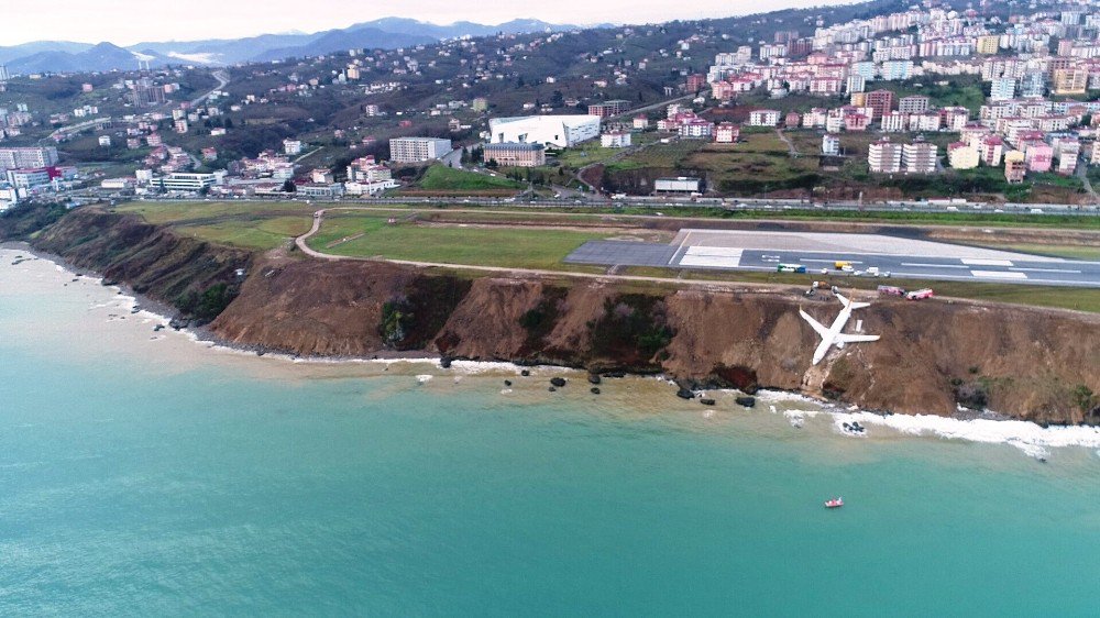
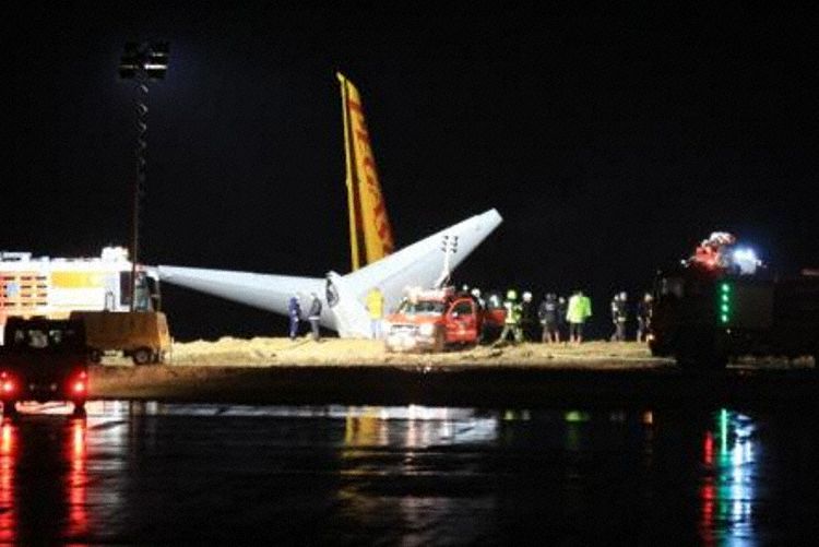
Un Boeing 737-800, registro TC-CPF de Pegasus Airlines efectuó el vuelo PC-8622 de Ankara a Trabzon (Turquía) con 162 pasajeros y 6 tripulantes. Al momento de efectuar el aterrizaje en la pista 11 de Trabzon a las 23: 26L (20: 26Z) viró a la izquierda de la pista y descendió por la pendiente al costado de la pista y se detuvo en un terreno blando, a unos 60 metros del mar antes del final de la pista y unos 60 metros a la izquierda del borde de la pista izquierda. El avión fue evacuado. No hubo heridos, el avión sufrió daños sustanciales.

La aerolínea confirmó que el vuelo PC-8622 tuvo un incidente en la pista cuando aterrizó en Trabzon. El avión transportaba a 162 pasajeros, 2 pilotos y 4 tripulantes, todos desembarcaron de manera segura, no hubo heridos. El gobernador de Trabzon informó que no hubo heridos. Los servicios de emergencia locales informaron que 3 personas fueron llevadas a hospitales con lesiones menores.

Los datos sugieren que la aeronave aterrizó normalmente a 143 nudos sobre el suelo. El incidente ocurrió el sábado por la noche en el aeropuerto de Trabzon, en el noreste de Turquía.

Vuelo de Pegasus Airlines se desliza fuera de la pista turca en la costa del Mar Negro, los pasajeros escapan ilesos. El incidente ocurrió el sábado por la noche en el aeropuerto de Trabzon, en el noreste de Turquía. Tras el aterrizaje del Boeing 737-800 terminó a mitad de camino en una empinada ladera del Aeropuerto de Trabzon en el Mar Negro. AIRWAYS® AW-Icon TXT

DTfIwtWX0AEj_prDTfIxblX0AE_o5eDTfIyMVXUAA6Hbhpegasus_b738_tc-cpf_trabzon_180113_1

Accident Boeing 737 Pegasus in Trabzon

A Boeing 737-800 skid slopes at Trabzon Airport, Turkey

A Boeing 737-800, registration TC-CPF of Pegasus Airlines made the PC-8622 flight from Ankara to Trabzon (Turkey) with 162 passengers and 6 crew members. At the time of landing on runway 11 of Trabzon at 23: 26L (20: 26Z) he turned left of the runway and descended the slope on the side of the runway and stopped on soft ground, about 60 meters from the sea before the end of the track and about 60 meters to the left of the edge of the left track. The plane was evacuated. There were no injuries, the plane suffered substantial damage.

The airline confirmed that flight PC-8622 had an incident on the runway when it landed in Trabzon. The plane was carrying 162 passengers, 2 pilots and 4 crew members, all disembarked safely, there were no injuries. The governor of Trabzon reported that there were no injuries. Local emergency services reported that 3 people were taken to hospitals with minor injuries.

DTfkw4vXcAAJxVu

The data suggest that the aircraft landed normally at 143 knots above the ground. The incident occurred on Saturday night at the Trabzon airport in northeastern Turkey.

Pegasus Airlines flight slides off the Turkish track on the Black Sea coast, passengers escape unharmed. The incident occurred on Saturday night at the Trabzon airport in northeastern Turkey. After landing the Boeing 737-800 ended halfway on a steep slope of the Trabzon Airport on the Black Sea. A \ W

VIDEO > https://player.vimeo.com/video/251020866«>

Ξ A I R G W A Y S Ξ
SOURCE:  Airgways.com
DBk: Avherald.com / Flypgs.com / Turkish Air News (@AnalystTK) / Jacdec.de / Vimeo..com [Erhan Aydoğdu]

AW-POST: 201801141106AR

A\W   A I R G W A Y S ®


MH370 Investigación en el Séptimo Arco

maxresdefault.jpg

AW | 2018 01 12 18:21 | AIR INVESTIGATION / AVIATION SAFETY

Resultado de imagen para MH370 logoLa investgación del vuelo MH370 de Malaysia Airlines está considerando un nuevo área de búsqueda propuesta a 35 grados al sur en el sur del Océano Índico

La investigación del fatídico vuelo MH370 está tomando otro curso de investigación con las evidencias aportadas hasta la fecha. La falta de escombros enla costa australiana, aparte de una toallita pequeña supuestamente proveniente del Malaysia Airlines que se encontró en una playa Western Australia en 2015 que puede o no haber provenido de MH370; cada pedazo de escombros que se sabe que proviene del avión desaparecido apareció en la costa este de África o cerca de las islas del Océano Índico.

Curso de la investigación dle MH370

Los investigadores australianos creen significativo que hay cinco posibles modos de control del piloto automático en los que el avión podría haber estado en el momento en que se quedó sin combustible y se estrelló en el océano.

Los cálculos basados ​​en cuatro de esos ajustes apuntan a un sitio de colisión más al sur, 36º-39º latitud sur o más al norte 33º-34º latitud sur, donde las corrientes oceánicas en los días posteriores al despegue del avión corrieron hacia el este, y se espera que lave al menos algunos restos hacia Australia.

Una fuente cercana a la investigación dice que solo uno de los cinco ajustes del piloto automático, el rumbo magnético constante (CMH), llevaría a un sitio de impacto en 35ºS, donde la corriente del océano en ese momento corría en la dirección opuesta, hacia África.

Existe otra evidencia en las semanas y meses después de que el avión desapareció, los pings emitidos por el Boeing 777-200ER por partede los satelitales fueron recogidos del avión por el satélite británico Inmarsat, llevaron al equipo de búsqueda dirigido por Australia a centrarse en un área de 120,000 kilómetros cuadrados alrededor de 36º, o más al sur, una búsqueda que finalmente resultó infructuosa.

Solo ahora, desde el examen de varios escombros y estudios sobre patrones de deriva oceánica, el probable sitio de naufragio se desplazó hacia el norte a un área de alrededor de 35º latitud sur, sobre la línea imaginaria conocida como «séptimo arco», que muestra posibles ubicaciones del avión en el momento del séptimo ping.

Mapa del séptimo arco en el Océano Índico al sur de Perth, mostrando el séptimo arco

El gobierno malasio confirmó esta semana que había firmado un acuerdo para pagarle a la firma estadounidense de exploración de fondos marinos Ocean Infinity entre U$D 20 millones y U$D 70 millones si encuentra la aeronave desaparecida dentro de los 90 días de iniciar una nueva búsqueda. Su nave de búsqueda Seabed Constructor ya se dirige a la nueva zona de búsqueda y comenzará a recorrer el fondo del océano la próxima semana. Ocean Infinity confía en encontrar el avión si efectivamente está dentro del área de búsqueda. El explorador tiene una capacidad para cubrir 25,000 Kilómetros cuadrados dentro de las primeras tres o cuatro semanas de la búsqueda.

El Dr. David Griffin, un oceanógrafo australiano en el CSIRO, lideró el análisis de deriva que el año pasado ayudó a reducir la zona de búsqueda a un área no mayor a 25,000 kilómetros cuadrados, donde Ocean Infinity enfocará su búsqueda. «La razón oceanográfica de por qué 35 [grados sur] es más probable que digamos 34º, o 33º, o 32º, es que en todas esas latitudes la corriente va hacia el este», dijo el Dr. Griffin.

Escombros en costa Este de África

La configuración del piloto automático y el descubrimiento de escombros en África incluido un flaperón que se confirmó que provenía del vuelo MH370 no son la única evidencia que respalda la teoría de que el avión desaparecido se encuentra en la nueva zona de búsqueda propuesta, al norte del área ya buscada.

Image resultLas imágenes satelitales francesas que se vieron por primera vez en Marzo de 2014, aproximadamente una semana después de que el avión desapareció, mostraron objetos blancos en esta misma área, a 35º latitud sur. Las fotos francesas eran de mala calidad, por lo que es casi imposible ver cuáles eran los objetos. Fue entonces que los objetos fueron descartados como de poca importancia importancia. Otras fotos habían mostrado manchas similares en otras partes del sur del Océano Índico, muchas de las cuales fueron descartadas más tarde como contenedores de envío, basura oceánica general o incluso vainas de delfines.

Fotografías satelitales francesas en blanco y negro que muestran los objetos a unos 35 grados sur después de la desaparición del MH370

FOTOGRAFÍA SATELITAL FRANCESA TOMADA EN  2014 DÍAS POSTERIORES A LA DESAPARICIÓN DEL VUELO MH370

Pero a medida que otras evidencias comenzaron a apuntar más al norte los resultados del estudio de deriva de CSIRO y el descubrimiento de más restos relacionados con el avión perdido, los investigadores de pronto recordaron las imágenes de satélite. Le pidieron a los franceses mejores copias. Y solo entonces se dieron cuenta de que las fotos eran más significativas de lo que se pensaba. «Cuando alguien los mira, piensas, si no son trozos de avión, ¿qué son? Porque para muchos de esos otros objetos puedes encontrar una explicación, pero para estos no puedes», dijo el Dr. Griffin.

El análisis de deriva incluyó cálculos retrospectivos para medir dónde podrían haber estado los objetos en las horas posteriores a la desaparición de MH370. Efectivamente, fue alrededor de 35ºS, la nueva zona donde Ocean Infinity se está preparando para buscar. Cuando Ocean Infinity llegue a su destino la próxima semana, no será la primera vez que los buques de los fondos marinos hayan buscado a lo largo del séptimo arco a 35S.

En las semanas posteriores a la desaparición del MH370, los buscadores recorrieron el fondo oceánico a lo largo de la misma trayectoria desde aproximadamente 32º a 39º latitud sur, y no encontraron nada. Pero el Dr. Griffin dice que la búsqueda fue muy estrecha, apenas 20 kilómetros a cada lado del arco.

La nueva búsqueda escaneará un área más amplia. Aunque la evidencia que incluye el flaperón del avión, que se encontró en Tanzania, apoya la teoría de que el avión pasó por un descenso rápido una vez que se quedó sin combustible y aterrizó cerca del «séptimo arco».

El examen del flaperón indica que se retrajo en el momento del impacto, desacreditando la teoría de que el piloto todavía tenía el control y tratando de deslizar el avión lo más lejos posible antes de que se estrelló.

Image result for ATSB AustraliaLa evidencia en un informe de la Oficina de Seguridad del Transporte de Australia (ASTB) a fines de 2016 evaluando las comunicaciones satelitales desde el avión, conocida como Doppler Shift Burst Frequency Offset, también es consistente con un descenso rápido y el sitio del naufragio está más cerca del séptimo arco.

La nueva búsqueda comenzará la próxima semana. Para calificar para su día de pago multimillonario, Ocean Infinity debe encontrar el campo de desechos o los registradores de vuelo dentro de los 90 días. E incluso si se encuentra el avión, puede que nunca haya una explicación satisfactoria de por qué desapareció MH370.

El especialista en aviación Trevor Jensen expresó en la necesidad de observar cuán certero será encontrar el avión, ya que «las grabadoras de vuelo, las grabadoras de voz, ahora estarían tan dañadas».  AIRWAYS® AW-Icon TXT

MH370 Research in the Seventh Arc

Resultado de imagen para MH370 logoThere is a particularly tempting reason why the remnants of Malaysia Airlines flight MH370 can be found within the proposed new search area 35 degrees south in the southern Indian Ocean

It is the lack of any aircraft residue found on the west coast of Australia. In addition to a small towel in the Malaysia Airlines package found on a WA beach in 2015  which may or may not have come from MH370 every piece of debris known to come from the missing plane appeared on the east coast of Africa or near there. islands.

This is significant, given that Australian researchers believe that there are five possible autopilot control modes in which the aircraft could have been at the time it ran out of fuel and crashed into the ocean.

Calculations based on four of those adjustments point to a collision site farther south 36º-39º degrees south or farther north 33º-34º degrees south, where ocean currents in the days after the plane takes off They ran to the east, and are expected to wash at least some remains towards Australia.

A source close to the investigation says that only one of the five settings of the autopilot constant magnetic heading (CMH) would lead to an impact site in 35S, where the ocean current at that time was running in the opposite direction, towards Africa .

However, other evidence in the weeks and months after the plane disappeared, that is, the satellite «pings» collected from the plane by the British satellite Inmarsat, led the Australian-led search team to focus on an area of ​​120,000 kilometers. squares around 36 degrees. or further south, a search that ultimately proved unsuccessful.

Only now, from the examination of several debris and studies of oceanic drift patterns, the probable shipwreck site moved northward to an area of ​​about 35 degrees south, on the imaginary line known as the «seventh arc», which shows Possible locations of the plane at the time of the seventh «ping».

The Malaysian government confirmed this week that it had signed an agreement to pay US marine exploration firm Ocean Infinity between US $ 20 million and US $ 70 million if it finds the missing aircraft within 90 days of starting a new search. Your Seabed Builder search engine is already heading to the new search area and will start touring the ocean floor next week. Ocean Infinity is confident of finding the plane if it is indeed within the search area. The explorer has a capacity to cover 25,000 square kilometers within the first three or four weeks of the search.

Dr. David Griffin, an Australian oceanographer at CSIRO, led the drift analysis that last year helped reduce the search area to an area no larger than 25,000 square kilometers, where Ocean Infinity will focus its search. «The oceanographic reason why 35 [south degrees] is more likely to say 34º, or 33º, or 32º, is that in all those latitudes the current is going east», said Dr. Griffin.

Debris on East coast of Africa

The configuration of the autopilot and the discovery of debris in Africa including a flaperon that was confirmed to be from flight MH370 are not the only evidence that supports the theory that the missing plane is located in the proposed new search area, to the north of the area already searched.

The French satellite images that were first seen in March 2014, about a week after the plane disappeared, showed white objects in this same area, at 35º south latitude. The French photos were of poor quality, so it is almost impossible to see what the objects were. It was then that the objects were discarded as of minor importance. Other photos had shown similar spots in other parts of the southern Indian Ocean, many of which were later discarded as shipping containers, general ocean litter or even dolphin pods.

But as other evidence began to point northward at the results of the CSIRO drift survey and the discovery of more remains related to the lost plane, the researchers suddenly recalled the satellite images. They asked the French for better copies. And only then did they realize that the photos were more significant than previously thought. «When someone looks at you, you think, if they are not airplane pieces, what are they? Because for many of those other objects you can find an explanation, but for these you can not», said Dr. Griffin.

The drift analysis included retrospective calculations to measure where the objects might have been in the hours after the disappearance of MH370. Indeed, it was around 35ºS, the new area where Ocean Infinity is preparing to search. When Ocean Infinity arrives at its destination next week, it will not be the first time that deep-sea vessels have searched along the seventh arc at 35S.

In the weeks after the disappearance of the MH370, the searchers traversed the ocean floor along the same path from approximately 32º to 39º south latitude, and found nothing. But Dr. Griffin says the search was very narrow, barely 20 kilometers on each side of the arch.

The new search will scan a wider area. Although the evidence that includes the plane’s flaperon, which was found in Tanzania, supports the theory that the plane went through a rapid descent once it ran out of fuel and landed near the «seventh arc».

The examination of the flaperon indicates that it retracted at the time of impact, discrediting the theory that the pilot was still in control and trying to glide the aircraft as far as possible before it crashed.

Evidence in a report from the Australian Transportation Security Office (ASTB) in late 2016 evaluating satellite communications from the plane, known as Doppler Shift Burst Frequency Offset, is also consistent with a rapid decline and the wreck site is closer to the seventh arc.

The new search will begin next week. To qualify for your multi-million dollar payday, Ocean Infinity must find the waste field or flight recorders within 90 days. And even if the plane is found, there may never be a satisfactory explanation of why MH370 disappeared.

Aviation specialist Trevor Jensen expressed the need to observe how accurate it will be to find the plane, since «the flight recorders, the voice recorders, would now be so damaged». A \ W


Ξ A I R G W A Y S Ξ
SOURCE:  Airgways.com
DBk: Atsb.com.au / Ga.gov.au / Defense.gouv.fr / Telegraph.co.uk
AW-POST: 201801121821AR

A\W   A I R G W A Y S ®
Colisión plataforma Aeropuerto Toronto

AW | 2018 01 06 23:37 | AVIATION SAFETY


Dos aeronaves de Sunwing Airlines y Westjet Airlines colisionan en plataforma del Aeropuerto Internacional de Toronto provocando fuego y evacuación

Dos aviones comerciales chocaron el viernes por la noche en el Aeropuerto Internacional Toronto-Pearson de Canadá, provocando un pequeño incendio y la evacuación de docenas de pasajeros, dijo la autoridad aeroportuaria de la ciudad.

Dos aviones Boeing 737-800 estuvieron involucrados en una colisión en la plataforma del Aeropuerto Internacional Pearson de Toronto, Canadá. El vuelo WS2425 de WestJet Airlines, un Boeing 737-800 con registro C-FDMB, aterrizó en la pista 24R a las 17:39 horas, hora local, después de un vuelo desde Cancún, México.  Los informes preliminares sugieren que la aeronave estaba estacionada en la calle de rodaje cerca de la puerta cuando otro Boeing 737-800 estaba siendo empujado hacia atrás desde la puerta A14 (Terminal 3). El avión registro C-FPRP, operado por Sunwing Airlines había llegado desde el Aeropuerto de Cancún como el vuelo WG272 y se había estacionado en la puerta A14 a las 16:38 horas.

Resultado de imagen para Westjet Sunwing

Durante el retroceso, la APU del Boeing 737-800 de Sunwins Airlines impactó la punta del ala del avión WestJet. Un incendio estalló en la APU y la punta del ala del WS2425 quedó envuelta en llamas. El avión de WestJet fue posteriormente evacuado en la calle de rodaje. El fuego APU fue contenido rápidamente.

Según Lauren Stewart, una portavoz de WestJet, había 168 pasajeros y seis tripulantes a bordo del avión que llegaba. No hay pasajeros ni miembros de la tripulación a bordo del avión Sunwing, sin provocar ningún herido.

Los camiones de bomberos y las ambulancias descendieron sobre la pista cuando comenzó un pequeño incendio en el avión Sunwing, dijo Beverly MacDonald, vocera de la Autoridad Aeroportuaria del Gran Toronto.

Adriana Lobo, quien viajaba con sus hijos a bordo del avión de WestJet, dijo que los pasajeros inicialmente no estaban seguros de lo que había sucedido hasta que fueron evacuados.

Otra colisión en el John F. Kennedy

El viernes por la noche en Nueva York, también ocurrió un accidente en una pista en el Aeropuerto Internacional John F. Kennedy cuando el ala derecha de un avión de China Southern Airlines inclinó la cola de un avión de Kuwait Airlines, dijeron las Autoridades Portuarias de Nueva York y Nueva Jersey. No se informaron heridos, y los pasajeros de Kuwait se desembarcaron de forma segura, dijo el portavoz de la Autoridad Portuaria, Ron Marsico. No hubo pasajeros en el avión China Southern, dijo Marsico.  AIRWAYS® AW-Icon TXT

Collision platform Toronto Airport

Two aircraft of Sunwing Airlines and Westjet Airlines collide on the platform of the Toronto International Airport causing fire and evacuation

Two commercial jets collided Friday night at Toronto-Pearson International Airport in Canada, causing a small fire and the evacuation of dozens of passengers, the city’s airport authority said.

Two Boeing 737-800 aircraft were involved in a collision on the platform of Pearson International Airport in Toronto, Canada. WestJet Airlines flight WS2425, a Boeing 737-800 with registration C-FDMB, landed on runway 24R at 5:39 p.m., local time, after a flight from Cancun, Mexico. Preliminary reports suggest that the aircraft was parked on the taxiway near the door when another Boeing 737-800 was being pushed back from gate A14 (Terminal 3). The C-FPRP registration plane, operated by Sunwing Airlines, had arrived from Cancun Airport as flight WG272 and had parked at Gate A14 at 16:38.

During the retreat, the APU of the Boeing 737-800 from Sunwins Airlines impacted the wing tip of the WestJet aircraft. A fire broke out in the APU and the tip of the wing of the WS2425 was engulfed in flames. The WestJet plane was subsequently evacuated on the taxiway. The APU fire was quickly contained.

According to Lauren Stewart, a spokeswoman for WestJet, there were 168 passengers and six crew on board the arriving plane. There are no passengers or crew members aboard the Sunwing plane, causing no injuries.

Fire trucks and ambulances descended on the runway when a small fire started on the Sunwing plane, said Beverly MacDonald, spokeswoman for the Greater Toronto Airport Authority.

Adriana Lobo, who was traveling with her children aboard the WestJet plane, said passengers initially were not sure what had happened until they were evacuated.

Another collision in the John F. Kennedy

On Friday night in New York, an accident occurred on a runway at the John F. Kennedy International Airport when the right wing of a China Southern Airlines plane tipped the tail of a Kuwait Airlines plane, Port Authorities said. New York and New Jersey. No injuries were reported, and Kuwaiti passengers disembarked safely, said Port Authority spokesman Ron Marsico. There were no passengers on the China Southern plane, said Marsico. A \ W


Ξ A I R G W A Y S Ξ
SOURCE:  Airgways.com
DBk: Thestar.com / 680news.com / Firstpost.com
AW-POST: 201801062337AR

A\W   A I R G W A Y S ®

El «Bomb Cyclone» amenaza EEUU

AW | 2018 01 04 23:07 | AIRPORT / AVIATION SAFETY

El histórico «Ciclón de la Bomba» desata condiciones de tormenta desde la costa de Virginia hasta Nueva Inglaterra en Estados Unidos

Se cancelan más de 2.700 vuelos, se cierran escuelas y se advierte a los conductores que se mantengan alejados de las carreteras mientras el intenso «ciclón de la bomba» avanza hacia el noreste luego de una rara nevada en Florida y el sureste.

Se espera que el «Ciclón de la Bomba» sea el huracán de invierno más intenso de la región en décadas, provocando una ráfaga de advertencias de frío y congelación desde Florida hasta Maine. Al menos un lugar en cada estado golpea bajo cero el miércoles y se espera que haga lo mismo el jueves. Al menos 17 muertes se han atribuido a temperaturas peligrosamente frías que durante varios días se han apoderado de amplias áreas de los EEUU. Desde Texas hasta Nueva Inglaterra las aerolíneas han cancelado más de 2.700 vuelos ya que las condiciones casi récord persisten en todo el litoral oriental a última hora del miércoles y hasta el jueves.

La mayoría de las cancelaciones de vuelos fueron para vuelos programados para partir o llegar a algunos de los grandes aeropuertos del noreste, incluidos Logan, JFK, LaGuardia y el aeropuerto internacional de Newark. El Aeropuerto Internacional de Jacksonville tiene retrasos, mientras que el Aeropuerto Internacional de Charleston en Carolina del Sur, el Aeropuerto de Boston, Massachusetts y el Aeropuerto Internacional de Savannah / Hilton Head, Georgia, se cierran por completo.

Se espera que el ciclón de la bomba provoque condiciones parecidas a ventiscas y vientos de hasta 60 mph a Boston, Long Island y Maine y ocho pulgadas de nieve a la ciudad de Nueva York donde las temperaturas frías del viento caigan a -20ºC el viernes.

La inusual tormenta invernal que pegó partes de Florida, Georgia y Carolina del Sur con hielo y nieve el miércoles se intensificó explosivamente la noche del miércoles convirtiéndose en una de las tormentas invernales más fuertes de la costa este en la historia moderna.

Las advertencias de Blizzard se extienden desde la región del Estado de Virginia hasta el este del Estado de Maine. La nieve caida excede un pie en algunos lugares, y ráfagas de viento de al menos 40 a 60 mph.

Entre el miércoles y el jueves por la mañana, la tormenta se fortaleció a un ritmo sorprendente, superando los criterios meteorológicos para ser considerado el llamado «ciclón de la bomba». Una tormenta se clasifica como tal si su presión cae 24 milibares en 24 horas. La presión de esta tormenta vertió 53 milibares en 21 horas (y 59 milibares en 24 horas ), lo que la coloca en el escalón más alto de las tormentas más explosivas de la Costa Este jamás observadas.

A medida que la tormenta florecía el miércoles y el jueves con tormentas eléctricas que estallaban alrededor de su centro en forma de coma, los meteorólogos expresaban admiración pura ante la maravilla meteorológica.

El Servicio Meteorológico Nacional advirtió que los fuertes vientos de la tormenta probablemente provocarían apagones. El jueves por la tarde, varias ráfagas de viento de al menos 70 mph se registraron en la costa de Massachusetts.

El Servicio Meteorológico tuiteó que la observación de la marea de Boston se estaba acercando a su nivel más alto jamás registrado (1921) el jueves por la tarde temprano. Se dijo que se iba a “inundado con reportes de inundaciones costeras  algunos de los peores en la historia reciente”.

El Aeropuerto Internacional de Norfolk informó 10 pulgadas de la tormenta. Se observaron condiciones similares en Ocean City, que recibió 11.0 pulgadas. En Atlantic City, el meteorólogo Joe Martucci informó que la nieve «soplaba y se desplazaba a la deriva en su máxima expresión y la cantidad subió a 16 pulgadas en partes de South Jersey».

El Aeropuerto Internacional de Atlantic City publicó 12.7 pulgadas de nieve a la 1 pm La fuerte nevada y los vientos que soplan a 30 mph azotaron la ciudad de Nueva York, bajo una advertencia de tormenta invernal.

Las condiciones de whiteout suspendieron temporalmente los vuelos en el Aeropuerto JFK, donde el viento soplaba a una velocidad de hasta 55 mph. Central Park reportó 7.8 pulgadas de nieve a la 1 pm en Long Island, las condiciones eran aún más severas.

El Aeropuerto de Islip reportó cinco horas seguidas de fuertes nevadas, velocidades de nevadas de 3 pulgadas por hora y ráfagas de viento a 45 mph verdaderas condiciones de tormenta de nieve. Su total de nieve subió a 13.6 pulgadas.

La gran tormenta del «Bomb Cyclone» de frío y nieve continuará afectando Estados Unidos durante varios días más. AIRWAYS® AW-Icon TXT

The «Bomb Cyclone» threatens the US

The historic «Cyclone of the Bomb» unleashes storm conditions from the coast of Virginia to New England in the United States

More than 2,700 flights are canceled, schools are closed and drivers are warned to stay clear of the roads as the intense «Cyclone of the Bomb» moves towards the northeast after a rare snowfall in Florida and the southeast.

The «cyclone of the bomb» is expected to be the region’s most intense winter hurricane in decades, triggering a flurry of cold and freeze warnings from Florida to Maine. At least one place in each state hits below zero on Wednesday and is expected to do the same on Thursday. At least 17 deaths have been attributed to dangerously cold temperatures that have seized large areas of the US for several days. From Texas to New England, airlines have canceled more than 2,700 flights as near-record conditions persist across the eastern seaboard late on Wednesday and through Thursday.

The majority of flight cancellations were for flights scheduled to depart or arrive at some of the major airports in the Northeast, including Logan, JFK, LaGuardia and Newark International Airport. The Jacksonville International Airport has delays, while the Charleston International Airport in South Carolina, the Boston Airport, Massachusetts and the Savannah / Hilton Head International Airport, Georgia, are completely closed.

The cyclone of the bomb is expected to cause blizzard-like conditions and winds of up to 60 mph to Boston, Long Island and Maine and eight inches of snow to New York City where cold wind temperatures drop to -20ºC on Friday.

The unusual winter storm that hit parts of Florida, Georgia and South Carolina with ice and snow on Wednesday intensified explosively on Wednesday night becoming one of the strongest winter storms on the east coast in modern history.

Blizzard warnings extend from the region of the State of Virginia to the east of the State of Maine. The fallen snow exceeds a foot in some places, and gusts of wind of at least 40 to 60 mph.

Between Wednesday and Thursday morning, the storm strengthened at a surprising rate, surpassing the meteorological criteria to be considered the so-called «cyclone of the bomb». A storm is classified as such if its pressure drops 24 millibars in 24 hours. The pressure of this storm poured 53 millibars in 21 hours (and 59 millibars in 24 hours), which places it at the highest echelon of the most explosive storms on the East Coast ever observed.

As the storm blossomed on Wednesday and Thursday with thunderstorms bursting around its center in a coma, meteorologists expressed pure admiration for the meteorological wonder.

The National Weather Service warned that the strong winds of the storm would probably cause blackouts. On Thursday afternoon, several wind gusts of at least 70 mph were recorded off the coast of Massachusetts.

The Weather Service tweeted that the observation of the Boston tide was approaching its highest level ever recorded (1921) on early Thursday afternoon. He was said to be «inundated with reports of coastal flooding some of the worst in recent history».

The Norfolk International Airport reported 10 inches of the storm. Similar conditions were observed in Ocean City, which received 11.0 inches. In Atlantic City, meteorologist Joe Martucci reported that the snow «was blowing and drifting at its best andthe amount went up to 16 inches in parts of South Jersey».

The Atlantic City International Airport posted 12.7 inches of snow at 1 pm Heavy snowfall and winds blowing at 30 mph hit New York City, under a winter storm warning.

Whiteout conditions temporarily suspended flights at JFK Airport, where the wind was blowing at a speed of up to 55 mph. Central Park reported 7.8 inches of snow at 1 pm on Long Island, conditions were even more severe.

Islip Airport reported five consecutive hours of heavy snowfall, snowfall speeds of 3 inches per hour and wind gusts at 45 mph true snowstorm conditions. His total snow climbed to 13.6 inches.

The great storm of the «Bomb Cyclone» of cold and snow will continue to affect the United States for several more days. A \ W


Ξ A I R G W A Y S Ξ
SOURCE:  Airgways.com
DBk:  Washingtonpost.com / Weather.com / Dailymail.co.uk / Sinclairstoryline.com
AW-POST: 201801042307AR

A\W   A I R G W A Y S ®

La seguridad aviación comercial en 2017

AW | 2018 01 01 11:55 | AVIATION SAFETY

Resultado de imagen para To70El 2017 ha sido un año en el que más personas volaron a más lugares que nunca, fue el año más seguro registrado para los pasajeros de aerolíneas en varios años

La consultora de aviación con sede en los Países Bajos, To70, lanzó su Revisión de Seguridad de la Aviación Civil para 2017. Reporta solo dos accidentes mortales, ambos con pequeños aviones turbohélice, con un total de 13 vidas perdidas. Ningún avión se estrelló en el servicio de pasajeros en ninguna parte del mundo.

Los dos accidentes que ocurrieron en la víspera de Año Nuevo  un hidroavión en Sydney que mató a seis, y una Cessna Caravan que se estrelló en Costa Rica , matando a los 12 a bordo no están incluidos en el recuento, ya que ambos aviones pesaban menos del umbral de 5.700 kg para el informe.

El primer accidente mortal incluido en el informe fue en Octubre: un Embraer Brasilia que operaba como ambulancia aérea en Angola. Los pilotos perdieron el control después de sufrir una falla en el motor, siete personas murieron, incluido el paciente. En Noviembre, un Let 410 de construcción checa perteneciente a Khabarovsk Avia se estrelló al aterrizar en Nelkan en el Lejano Oriente ruso con la pérdida de seis vidas. Una niña de cuatro años fue la única superviviente. Un número de muertos mucho mayor ocurrió en Bishkek, la capital de Kirguistán, cuando un carguero Boeing 747 turco perteneciente a ACT AIrlines traspasó la pista y terminó en una aldea cercana al aeropuerto, matando a 35 personas en el suelo y cuatro tripulantes. Además, la explosión de un jet mató a un turista parado cerca de la pista de aterrizaje en la isla caribeña de St Maarten.

Las posibilidades de que un avión se vea involucrado en un accidente fatal ahora son de una en 16 millones, según el investigador principal, Adrian Young. Pero el Sr. Young, consultor de aviación senior para To70, comentó: «Es poco probable que se mantenga este mínimo histórico; en parte, estas figuras muy positivas descansan en la buena fortuna. Sin embargo, el nivel de seguridad que ha logrado la aviación civil es notable. Los riesgos para la aviación civil siguen siendo altos, como lo demuestra la gravedad de algunos de los accidentes no mortales. La espectacular pérdida del ventilador de entrada y el capó de un motor en un Air France A380 sobre el espacio aéreo deGroenlandia en Septiembre habla a las claras de la confiabilidad en la aviación».

Desafíos por delante
El informe advierte que los dispositivos electrónicos en los bolsos facturados representan un creciente peligro potencial: «El creciente uso de baterías de iones de litio en la electrónica crea un riesgo de incendio en los aviones, ya que estas baterías son difíciles de extinguir si se incendian. Las aerolíneas de todo el mundo están entrenando a sus equipos para combatir cualquier incendio en la cabina; el desafío es mantener esas baterías fuera del equipaje de los pasajeros.

En 2016, 271 personas perdieron la vida en siete eventos fatales. Incluyeron el trágico accidente del vuelo MS804 de Egyptair en la ruta París—El Cairo que mató a 66 pax, y un avión British Aerospace BAe 146-200 de LaMia Airlines que transportaba al equipo de fútbol brasileño Chapecoense, que se quedó sin combustible en Colombia y se estrelló con la pérdida de 71 vidas.

El número de muertos en los dos años anteriores (2014—2015) fue significativamente mayor. En 2014, 864 personas murieron en cinco accidentes, incluidas las pérdidas de dos Malaysia Airlines 777: MH370, cuyo destino aún se desconoce y el vuelo MH17, derribado por un misil en el este de Ucrania. En 2015, 471 personas murieron en cuatro accidentes; incluyeron un vuelo de Metrojet de Sharm el Sheikh a San Petersburgo, Rusia, que mató a 224, y un Germanwings Airbus A320 de Barcelona a Dusseldorf cuyo primer oficial, Andreas Lubitz, mató a 150 a bordo al estrellarse deliberadamente contra los Alpes franceses,

El Reino Unido tiene el mejor registro de seguridad aérea de cualquier país importante. No han ocurrido accidentes fatales con una aerolínea británica desde la década de 1980. El último fue el 10 de enero de 1989; 47 personas murieron cuando un British Midland Boeing 737 se estrelló en Kegworth en Leicestershire.

Por el contrario, África subsahariana tiene una tasa de accidentes 44% peor que el promedio mundial, según la Asociación Internacional de Transporte Aéreo (IATA). En Noviembre, Alexandre de Juniac, director general de IATA, dijo: «La seguridad en África ha mejorado, pero hay una brecha por cerrar».  AIRWAYS® AW-Icon TXT

Security in commercial aviation in 2017

Resultado de imagen para To702017 has been a year in which more people flew to more places than ever, it was the safest year registered for airline passengers in several years

The aviation consultancy based in the Netherlands, To70, launched its Civil Aviation Safety Review for 2017. It reports only two fatal accidents, both with small turboprop aircraft, with a total of 13 lives lost. No plane crashed in passenger service anywhere in the world.

Aviation ConsultantsThe two accidents that occurred on New Year’s Eve – a seaplane in Sydney that killed six, and a Cessna Caravan that crashed in Costa Rica, killing all 12 on board are not included in the count, as both aircraft weighed less than the 5,700 kg threshold for the report.

The first fatal accident included in the report was in October: an Embraer Brasilia that operated as an air ambulance in Angola. The pilots lost control after suffering a failure in the engine, seven people died, including the patient. In November, a Let 410 of Czech construction belonging to Khabarovsk Avia crashed when landing in Nelkan in the Russian Far East with the loss of six lives. A four-year-old girl was the only survivor. A much larger death toll occurred in Bishkek, the capital of Kyrgyzstan, when a Turkish Boeing 747 freighter belonging to ACT AIrlines crossed the runway and ended up in a village near the airport, killing 35 people on the ground and four crew. In addition, the explosion of a jet killed a tourist standing near the airstrip on the Caribbean island of St Maarten.

The chances of an aircraft being involved in a fatal accident are now one in 16 million, according to the principal investigator, Adrian Young. But Mr. Young, a senior aviation consultant for To70, commented: «It is unlikely that this historic minimum will be maintained – in part, these very positive figures rest on good fortune, however, the level of safety that the Civil aviation is notable The risks to civil aviation remain high, as evidenced by the severity of some of the non-fatal accidents The spectacular loss of the inlet fan and the hood of an engine in an Air France A380 over airspace deGroenlandia in September speaks clearly about reliability in aviation».

Challenges ahead
The report warns that electronic devices in billed bags represent a growing potential danger: «The increasing use of lithium-ion batteries in electronics creates a fire risk in aircraft, since these batteries are difficult to extinguish if they catch fire. Airlines around the world are training their equipment to fight any fire in the cabin, the challenge is to keep those batteries out of passengers’ luggage.

In 2016, 271 people lost their lives in seven fatal events. They included the tragic accident of Egyptair’s MS804 flight on the Paris-Cairo route that killed 66 people, and a British Aerospace BAe 146-200 plane from LaMia Airlines carrying the Brazilian soccer team Chapecoense, which ran out of fuel in Colombia and it crashed with the loss of 71 lives.

The number of deaths in the two previous years (2014-2015) was significantly higher. In 2014, 864 people died in five accidents, including the losses of two Malaysia Airlines 777: MH370, whose fate is still unknown and flight MH17, shot down by a missile in eastern Ukraine. In 2015, 471 people died in four accidents; they included a Metrojet flight from Sharm el Sheikh to Saint Petersburg, Russia, which killed 224, and a Germanwings Airbus A320 from Barcelona to Dusseldorf whose first officer, Andreas Lubitz, killed 150 on board when deliberately crashed into the French Alps,

The United Kingdom has the best air safety record of any major country. There have been no fatal accidents with a British airline since the 1980s. The last was on January 10, 1989; 47 people died when a British Midland Boeing 737 crashed at Kegworth in Leicestershire.

In contrast, sub-Saharan Africa has an accident rate 44% worse than the global average, according to the International Air Transport Association (IATA). In November, Alexandre de Juniac, general director of IATA, said: «Security in Africa has improved, but there is a gap to close». A \ W


Ξ A I R G W A Y S Ξ
SOURCE:  Airgways.com
DBk: To70.com / Airgways.com
AW-POST: 201801011155AR

A\W   A I R G W A Y S ®