Cancelaciones por Huracán Florence

Resultado de imagen para hurricane florence airport

AW | 2018 09 11 17:25 | AVIATION SAFETY

Resultado de imagen para National Hurricane Center (NHC) hurricane florenceAvanza el Huracán Florence hacia la costa este de Estados Unidos

El Centro Nacional de Huracanes (NHC) alertó de que el Huracán Florence llegará durante esta semana a Estados Unidos, Islas Bermundas y Bahamas. Tras el anuncio, las aerolíneas han reaccionado informando sobre la exención de pagos para los vuelos que puedan ser cancelados. Ante la inminente llegada del fenómeno natural al sudeste de los EEUU, American Airlines y Southwest Airlines han informado en redes sociales que sus vuelos pueden verse afectados en los próximos días. “Cuando hay clima severo o eventos incontrolables y puedan afectar tus vuelos y fechas de viaje, puedes cambiar tus boletos sin pagar extra”, señaló American en un comunicado de prensa. De su lado, Southwest emitió una medida similar.

El Huracán Florence se encuentra en Categoría 2 que ha alcanzado los 169 kilómetros/hora sobre el Atlántico Norte, que comenzarán a impactar en los estados de Carolina del Sur y Carolina del Norte (Estados Unidos), pudiendo alcanzar la Categoría 3.

Aeropuertos zona de Huracán Florence

Los aeropuertos que podrían afectar el Huracán Florence pudieran ser: Estado de Carolina del Norte: Asheville, Charlotte, Fayetteville, Greensboro/High Point, Greenville, Jacksonville, New Bern, Raleigh/Durham y Wilmington. Esado de Carolina del Sur: Charleston, Columbia, Florence, Greenville/Spartansburg, Hilton Head y Myrtle Beach. En Georgia: Augusta y Savannah. Estado de Virginia: Charlottesville, Hampton/Newport News, Lynchburg, Norfolk, Richmond, y Roanoke.  AIRWAYS® AW-Icon TXT

[Image of probabilities of 34-kt winds]time of arrival graphic

Cancellations by Hurricane Florence

Hurricane Florence advances toward the east coast of the United States

The National Hurricane Center (NHC) warned that Hurricane Florence will arrive this week to the United States, the Bermuda Islands and the Bahamas. After the announcement, the airlines have reacted by informing about the exemption of payments for the flights that can be canceled. Given the imminent arrival of the natural phenomenon in the southeastern US, American Airlines and Southwest Airlines have reported on social networks that their flights may be affected in the coming days. When there is severe weather or uncontrollable events and can affect your flights and travel dates, you can change your tickets without paying extra, American said in a press release. On its side, Southwest issued a similar measure.

Hurricane Florence is in Category 2 that has reached 169 kilometers / hour over the North Atlantic, which will begin to impact the states of South Carolina and North Carolina (United States), and may reach Category 3.

Airports area of ​​Hurricane Florence

The airports that could affect Hurricane Florence could be: State of North Carolina: Asheville, Charlotte, Fayetteville, Greensboro / High Point, Greenville, Jacksonville, New Bern, Raleigh / Durham and Wilmington. South Carolina state: Charleston, Columbia, Florence, Greenville / Spartansburg, Hilton Head and Myrtle Beach. In Georgia: Augusta and Savannah. State of Virginia: Charlottesville, Hampton / Newport News, Lynchburg, Norfolk, Richmond, and Roanoke.  A \ W


Ξ A I R G W A Y S Ξ
SOURCE:  Airgways.com
DBk: Nhc.noaa.gov / Charlotteobserver.com
AW-POST: 201809111725AR

A\W   A I R G W A Y S ®

17º aniversario atentados 11-S

Resultado de imagen para 11-S

AW | 2018 09 11 16:16 | AIR INVESTIGATION / AVIATION SAFETY

17º aniversario de una de las tragedias aéreas más grandes que enlutaron al mundo

El 11 de septiembre de 2001 marcó un cambio en la historia de la humanidad como las fechas que cambiaron el curso del mundo moderno. La aviación comercial ha registrado una de las mayores tragedias aéreas efectuadas por atentados terroristas, experimentando la humanidad un acontecimiento fatídico con consecuencias devastadoras.

Un 11 Septiembre 2001, unos diecinueve miembros de la red extremista yihadista Al Qaeda concretaron una serie de atentados suicidas contra los Estados Unidos, provocando la muerte de 3.016 personas, más de 6000 heridos y con heridas abiertas de por vida.

El epicentro del terrible ataque, que generó la atención y conmoción del mundo entero, estuvo en el complejo de edificios del World Trade Center de la ciudad de Nueva York, donde cayeron las Torres Gemelas, como así los atentados sufridos al secuestro de los aviones comerciales estrellados.

Los atentados fueron cometidos por diecinueve miembros de Al Qaeda,​ divididos en cuatro grupos de secuestradores, cada uno de ellos con un terrorista piloto que se encargaría de pilotar el avión una vez ya reducida la tripulación de la cabina. El vuelo AA-011 de American Airlines y el vuelo UA-175 de United Airlines fueron los primeros en ser secuestrados, y ambos fueron estrellados contra las dos torres gemelas del World Trade Center, el primero contra la Torre Norte y el segundo poco después contra la Sur, provocando que ambos rascacielos se derrumbaran en las dos horas siguientes.

El tercer avión secuestrado pertenecía al vuelo AA-077 de American Airlines y fue empleado para ser impactado contra una de las fachadas (concretamente la fachada oeste) del Pentágono, en Virginia. El cuarto avión, perteneciente al vuelo 93 de United Airlines, no alcanzó ningún objetivo al haberse estrellado en campo abierto, cerca de Shanksville, en Pensilvania, tras perder el control en cabina como consecuencia del enfrentamiento de los pasajeros y tripulantes contra el comando terrorista. Tenía como objetivo el Capitolio de los Estados Unidos, ubicado en la ciudad de Washington D.C.

Conmemoración 11-S

17º aniversario de los ataques terroristas del 11 Septiembre 2001, la cual fue transmitida desde Memorial Plaza en el World Trade Center. Como cada año, el NYPD, el FDNY y otras agencias neoyorquinas honrarán con una ceremonia solemne a las casi 3.000 víctimas de los atentados y a los más de 6.000 heridos que lograron sobrevivir a los dramáticos ataques.

El primer minuto de silencio fue las 08:45 a.m., que coincide con el trágico momento en que el primero de los aviones, el vuelo AA-011 de American Airlines, se impactó contra la Torre Norte del World Trade Center. A las 09:30 a.m. se realizó el segundo minuto de silencio, que coincide con el momento exacto en el que el segundo avión se estrelló contra la Torre Sur. A las 09:37 a.m. estuvo programado el tercer minuto de silencio, que marca el momento en el que el vuelo AA-077 de American Airlines se impactó contra el Pentágono, una tragedia en la murieron los 64 pasajeros. El cuarto minuto de silencio se realizaron a las 09:59 a.m., que sería la hora en la que se derrumbó la Torre Sur. El quinto momento de silencio estuvo programado para las 10:03 a.m., que fue cuando el vuelo UA-093 de United Airlines se precipitó en Shanksville, Pensilvania, provocando la muerte de los 44 pasajeros a bordo. El sexto y último minuto de silencio se programó para las 10:28 a.m., que marca el derrumbe de la Torre Norte.

Línea de tiempo del 11S

Cronología de los atentados del 11 Septiembre 2001
08:00: El vuelo AA-011 de American Airlines, un Boeing 767 con 92 personas a bordo, despega del Aeropuerto Internacional Logan de Boston hacia Los Ángeles.18​
08:14: El vuelo 175 de United Airlines, un Boeing 767 con 65 personas a bordo, despega del Aeropuerto Internacional Logan de Boston hacia Los Ángeles.18​
08:19: La sobrecargo Betty Ong del vuelo AA-011 de American Airlines se comunica con la oficina de reservaciones de la compañía para informar que el avión parece estar siendo secuestrado.
08:21: El vuelo AA-077 de American Airlines, un Boeing 757 con 64 personas a bordo, despega del Aeropuerto Internacional Dulles de Washington D.C. hacia Los Ángeles.​
08:37: La FAA (La Administración Federal Aeronáutica) notifica al NORAD (North American Aerospace Defense Command, Mando de Defensa Aérea de América del Norte) que existe una sospecha de secuestro del vuelo AA-011 de American.​
08:41: El vuelo UA-093 de United Airlines, un Boeing 757 con 44 personas a bordo, despega del Aeropuerto Internacional de Newark hacia San Francisco.​
08:46: El vuelo 11 de American impacta contra la Torre Norte del World Trade Center (WTC).
09:02: Momento del segundo impacto contra la Torre Sur. Este atentado es observado en directo por millones de personas a través de la televisión. El vuelo 175 de United embiste la Torre Sur del World Trade Center. El suceso es cubierto en directo por diversas cámaras de televisión que enfocaban a las Torres Gemelas a causa de la densa humareda que surgía de la Torre Norte.
09:03: La FAA notifica al NORAD que existe una sospecha de secuestro del vuelo UA-175 de United.
09:07: El Jefe de Empleados de la Casa Blanca avisa al presidente George W. Bush que embistieron la segunda torre y que Estados Unidos se encuentra bajo ataque. El presidente se encontraba reunido con unos niños de una escuela primaria de Sarasota (Florida).​
09:08: la FAA prohíbe todos los despegues que se dirijan hacia o pasen sobre el espacio de Nueva York.
09:10-09:25: Richard Clarke, encargado de la oficina anti-terrorista, organiza una videoconferencia desde la Casa Blanca entre los más altos jefes militares para organizar la respuesta.​
09:21: Se cierran todos los túneles y puentes de la isla de Manhattan.​
09:26: La FAA prohíbe el despegue de todos los aviones civiles.​
09:31: El presidente George W. Bush pronuncia un discurso desde la escuela primaria en la que se encuentra, informando que se trata aparentemente de un acto terrorista.
09:34: La FAA notifica al NORAD que existe una sospecha de secuestro del vuelo AA-077 de American.
09:34: El presidente George W. Bush sale de la escuela primaria de Sarasota hacia el aeropuerto.
09:39: El vuelo AA-077 de American se estrella contra el Pentágono. Vídeo difundido por el Gobierno estadounidense del momento del impacto contra el Pentágono del vuelo AA-077 de American Airlines.
09:45: La FAA (con órdenes del Presidente) ordena a todos los aviones en vuelo aterrizar inmediatamente en el aeropuerto más cercano.
09:48: El Congreso y la Casa Blanca son evacuados.
09:57: El presidente Bush abandona Florida.
09:59: Se derrumba la Torre Sur.
10:03 o 10:06: El vuelo UA-093 de United cae en campo abierto en Shanksville, Pensilvania. Al parecer, se habría producido una lucha de la tripulación y los pasajeros con los secuestradores para retomar el control del aparato.
10:06: La FAA notifica al NORAD que existe una sospecha de secuestro del vuelo UA-093 de United.
10:28: Se derrumba la torre Norte. Las Torres Gemelas desaparecen del skyline de Nueva York y se convierten en la Zona cero.
El horario está establecido según la hora local de verano en el Este de los Estados Unidos (EDT). Para establecer el tiempo universal (UTC) deben sumarse cuatro horas a la hora local.
11:04: El edificio de las Naciones Unidas en Nueva York es evacuado.​
11:45: El Presidente Bush aterriza en la base de la Fuerza Aérea Barksdale, en Luisiana.
13:04: El Presidente Bush declara «alerta máxima» en todo el mundo y se dirige a la nación a través de los medios de comunicación desde la base aérea Barksdale.​
13:37: El Presidente Bush deja el Air Force One en la base Barksdale.​
14:51: La Marina envía destructores armados con misiles a Nueva York.
15:07: El Presidente Bush aterriza en la base aérea Offutt, en Nebraska.
16:36: El Presidente Bush deja el Air Force One en la base Offutt y ordena ser llevado a la Casa Blanca.
17:25: Se derrumba el edificio 7 de 47 pisos del World Trade Center.
19:00: El Presidente Bush llega a la Casa Blanca.​
20:30: El Presidente Bush habla a la nación desde el Despacho Oval, en la Casa Blanca. AIRWAYS® AW-Icon TXT

Resultado de imagen para 11-S

17th anniversary attacks 11-S

17th anniversary of one of the greatest air tragedies that enlightened the world

September 11, 2001 marked a change in the history of humanity as the dates that changed the course of the modern world. Commercial aviation has registered one of the greatest aerial trajedias carried out by terrorist attacks, experiencing humanity a fateful event with devastating consequences.

On September 11, 2001, some nineteen members of the extremist jihadist al Qaeda network carried out a series of suicide attacks against the United States, causing the death of 3,016 people, more than 6,000 wounded and with open wounds for life.

The epicenter of the terrible attack, which generated the attention and commotion of the whole world, was in the complex of buildings of the World Trade Center in New York City, where the Twin Towers fell, as well as the attacks suffered by the hijacking of commercial airplanes. starry

The attacks were committed by nineteen members of Al Qaeda, divided into four groups of kidnappers, each with a terrorist pilot who would be responsible for piloting the plane once the crew of the cabin was reduced. American Airlines flight AA-011 and UA-175 flight of United Airlines were the first to be hijacked, and both were crashed against the twin towers of the World Trade Center, the first against the North Tower and the second shortly after against the South, causing both skyscrapers to collapse in the next two hours.

The third hijacked plane belonged to American Airlines flight AA-077 and was used to be hit against one of the facades (specifically the west facade) of the Pentagon in Virginia. The fourth plane, belonging to flight 93 of United Airlines, did not reach any goal having crashed in the open field near Shanksville, Pennsylvania, after losing control in the cabin as a result of the confrontation of passengers and crew against the terrorist command. It aimed at the United States Capitol, located in the city of Washington D.C.

Commemoration 11-S

17th anniversary of the terrorist attacks of September 11, 2001, which was transmitted from Memorial Plaza in the World Trade Center. As every year, the NYPD, the FDNY and other New York agencies will honor with a solemn ceremony the almost 3,000 victims of the attacks and the more than 6,000 wounded who managed to survive the dramatic attacks.

The first minute of silence was 08:45 a.m., which coincides with the tragic moment when the first of the planes, American Airlines flight AA-011, hit the North Tower of the World Trade Center. At 09:30 a.m. The second minute of silence was held, which coincides with the exact moment when the second plane crashed into the South Tower. At 09:37 a.m. The third minute of silence was scheduled, marking the moment when American Airlines flight AA-077 hit the Pentagon, a tragedy in which 64 passengers died. The fourth minute of silence will be held at 09:59 a.m., which would be the time when the South Tower collapsed. The fifth moment of silence was scheduled for 10:03 a.m., which was when UA-093 flight of United Airlines rushed into Shanksville, Pennsylvania, causing the death of the 44 passengers on board. The sixth and last minute of silence was scheduled for 10:28 a.m., marking the collapse of the North Tower.

11S timeline

Chronology of the attacks of September 11, 2001
08:00: American Airlines flight AA-011, a Boeing 767 with 92 people on board, takes off from Logan International Airport in Boston to Los Angeles.18
08:14: United Airlines Flight 175, a Boeing 767 with 65 people on board, takes off from Logan International Airport in Boston to Los Angeles.18
08:19: The Betty Ong surcharge of American Airlines flight AA-011 communicates with the company’s reservations office to inform that the plane appears to be being hijacked.
08:21: American Airlines flight AA-077, a Boeing 757 with 64 people on board, takes off from Dulles International Airport in Washington D.C. to Los Angeles.
08:37: The FAA (Federal Aviation Administration) notifies the NORAD (North American Aerospace Defense Command, North American Air Defense Command) that there is a suspicion of hijacking American’s AA-011 flight.
08:41: United Airlines flight UA-093, a Boeing 757 with 44 people on board, takes off from Newark International Airport to San Francisco.
08:46: American flight 11 hits the North Tower of the World Trade Center (WTC).
09:02: Moment of the second impact against the South Tower. This attack is observed live by millions of people through television. United flight 175 hits the South Tower of the World Trade Center. The event is covered live by several television cameras that focused on the Twin Towers because of the dense smoke that emerged from the North Tower.
09:03: The FAA notifies NORAD that there is a suspicion of hijacking United’s UA-175 flight.
09:07: The Chief of White House Employees warns President George W. Bush that they rammed the second tower and that the United States is under attack. The president was meeting with children from a primary school in Sarasota, Florida.
09:08: The FAA prohibits all takeoffs that are directed to or pass over New York space.
09: 10-09: 25: Richard Clarke, in charge of the anti-terrorist office, organizes a videoconference from the White House among the highest military leaders to organize the response.
09:21: All tunnels and bridges on the island of Manhattan are closed.
09:26: The FAA prohibits the takeoff of all civilian aircraft.
09:31: President George W. Bush delivers a speech from the primary school he is in, reporting that it is apparently a terrorist act.
09:34: The FAA notifies NORAD that there is a suspicion of hijacking American’s AA-077 flight.
09:34: President George W. Bush leaves the Sarasota elementary school to the airport.
09:39: American flight AA-077 crashes into the Pentagon. Video broadcasted by the American Government of the moment of the impact against the Pentagon of the flight AA-077 of American Airlines.
09:45: The FAA (with orders from the President) orders all airplanes in flight to land immediately at the nearest airport.
09:48: Congress and the White House are evacuated.
09:57: President Bush leaves Florida.
09:59: The South Tower collapses.
10:03 or 10:06: UA-093 flight from United falls in open field in Shanksville, Pennsylvania. Apparently, there would have been a struggle by the crew and passengers with the hijackers to regain control of the aircraft.
10:06: The FAA notifies NORAD that there is a suspicion of hijacking United’s UA-093 flight.
10:28: The North Tower collapses. The Twin Towers disappear from the New York skyline and become Ground Zero.
The schedule is set according to the local summer time in the East of the United States (EDT). To establish Universal Time (UTC), four hours must be added to the local time.
11:04: The United Nations building in New York is evacuated.
11:45: President Bush lands at the Barksdale Air Force base in Louisiana.
13:04: President Bush declares «maximum alert» around the world and addresses the nation through the media from Barksdale Air Base.
13:37: President Bush leaves Air Force One at the Barksdale base.
14:51: The Navy sends destroyers armed with missiles to New York.
3:07 PM: President Bush lands at Offutt Air Base in Nebraska.
16:36: President Bush leaves Air Force One at the Offutt base and orders to be taken to the White House.
5:25 PM: Building 7 of 47 floors of the World Trade Center collapses.
7:00 pm: President Bush arrives at the White House.
20:30: President Bush speaks to the nation from the Oval Office, in the White House. A\W


Ξ A I R G W A Y S Ξ
SOURCE:  Airgways.com
DBk: Cnn.com / Wikimedia.org
AW-POST: 201809111616AR

A\W   A I R G W A Y S ®

Huracán Florence Categoría 4

AW | 2018 09 10 20:36 | AVIATION SAFETY

1f300El Huracán Florence gana fuerza como tormenta de categoría 4, apuntando a la costa este de los Estados Unidos

El Huracán Florence está creciendo en tamaño y fuerza a medida que avanza hacia el sudeste de los EEUU el Centro Nacional de Huracanes anticipa un mayor fortalecimiento de la tormenta y dice que se espera que toque tierra como un huracán extremadamente peligroso. A pesar de que no hubo vigilancia costera ni advertencia en vigor hasta la tarde del lunes por la tarde, el centro de huracanes anunció que podrían enviarse oleadas de tormentas y huracanes para partes de los estados del sudeste y medio del Atlántico el martes por la mañana.

TRAYECTORIA DEL HURACÁN FLORENCE

Las olas generadas por el huracán ya están afectando partes de la costa este y las Islas Bermudas. El centro dijo que es probable que las olas potentes causen olas peligrosas y rompan las condiciones actuales. Además, se predice que Florencia, a más de 1.700 millas de Cape Fear, Carolina del Norte, traerá impactos potencialmente mortales a Carolina del Norte y los estados vecinos a finales de esta semana.

La tormenta se fortaleció rápidamente el lunes y para el mediodía se reclasificó como un huracán de categoría 4, alcanzando ese estado un día antes de lo que los expertos habían predicho. El centro de huracanes citó datos de un avión de Hunter de Huracanes de la NOAA que mostró que Florence se estaba intensificando rápidamente, con vientos máximos sostenidos cerca de 140 mph.

En una actualización anterior, las autoridades dijeron que los vientos de Florencia podrían alcanzar 150 mph en las próximas 36 horas. La tormenta ya tiene 500 millas de ancho, lo que significa que una gran área estará en riesgo cuando se acerque a la tierra. Los impactos del huracán podrían variar desde una fuerte marejada ciclónica hasta inundaciones por lluvias torrenciales y vientos huracanados. Los meteorólogos advierten que la pista prevista probablemente cambie, pero por ahora, muestra el fuerte huracán que azota a la costa de Carolina del Norte, con una posible recalada al norte de Wilmington.

Una vez que toque tierra, se predice que Florencia se estancará y permanecerá sobre Carolina del Norte durante al menos 24 horas, aumentando la amenaza de inundaciones peligrosas, dijo el lunes el director del NHC, Ken Graham. Incluso en áreas alejadas de la costa, agregó, partes de Carolina del Norte y Virginia podrían ver totales de lluvia de 10-15 pulgadas en los próximos siete días.

A partir de las 5 p.m. ET, Florencia se movía a 13 mph, unas 525 millas al sur-sureste de Bermuda, dijo el centro de huracanes. A medida que se acerca a la costa atlántica de Estados Unidos, Florencia también se beneficiará de temperaturas de la superficie del mar muy cálidas de hasta 85 grados, dijo el Centro Nacional de Huracanes.

Como el meteorólogo Stu Ostro de The Weather Channel informa a través de Twitter, desde 1851, solo cuatro huracanes de categoría 4 han tocado tierra al norte de Florida en la costa este. La recalada más septentrional fue hecha por Hazel, una tormenta devastadora y letal que azotó la frontera de Carolina del Sur / Carolina del Norte en octubre de 1954.

Los meteorólogos dicen que Florencia pasará entre Bermudas y las Bahamas el martes y miércoles y comenzará su acercamiento a los Estados Unidos el jueves por la mañana. Se espera que los fuertes vientos de tormenta tropical comiencen a llegar a la costa de las Carolinas el jueves, dijo el Centro Nacional de Huracanes.

A medida que el peligro se hizo evidente durante el fin de semana, los gobernadores de Carolina del Norte, Carolina del Sur y Virginia declararon estados de emergencia. Instaron a los residentes a prepararse, una solicitud que va desde la fortificación de viviendas y la recolección de suministros hasta la preparación de posibles órdenes de evacuación.

La Marina de los EEUU también está tomando precauciones, y el Comando de Fuerzas de la Flota de los EEUU ordenó a casi 30 buques en el área de Hampton Roads de la costa de Virginia que salgan al mar para evitar la tormenta. Los buques que no pueden salir del puerto se prepararán por una variedad de medios, desde la adición de amarras y líneas de tormenta hasta el anclaje y la desconexión de los cables de toma de tierra.

Actualmente, Florence está proyectando vientos con fuerza de huracán (74 mph o más) hasta 30 millas desde su centro. Los meteorólogos dicen que debido al tamaño que se espera que alcance la tormenta, causará estragos independientemente de cuán fuertes sean sus vientos.

Florencia es uno de los tres huracanes en el Océano Atlántico, junto con Helene e Isaac. De las otras dos tormentas, que permanecen lejos de la tierra, Isaac representa el riesgo más inmediato. Con vientos de 75 mph, se espera que se fortalezca un poco antes de debilitarse cuando se acerque a las Antillas Menores el jueves.

Las tormentas peligrosas también amenazan partes de los EEUU en el Océano Pacífico. La mayor parte del estado de Hawái estuvo bajo una advertencia de tormenta tropical o vigilancia el lunes por la mañana, mientras el Huracán Olivia avanza hacia el oeste, con vientos de 85 mph.

El Huracán Olivia podría debilitarse y convertirse en una fuerte tormenta tropical en 48 horas, según el Centro de Huracanes del Pacífico Central en Honolulu . Pero los meteorólogos dicen que los residentes deben tener cuidado con la posibilidad de inundaciones y vientos peligrosos.

En la Isla de Guam, también en el Océano Pacífico, el Tifón Mangkhut, una tormenta de Categoría 4, se perdió por poco y causó un golpe directo a la isla.  AIRWAYS® AW-Icon TXT

Hurricane Florence Category 4

Hurricane Florence gains strength as a category 4 storm, targeting the east coast of the United States

Hurricane Florence is growing in size and strength as it moves toward the southeastern US The National Hurricane Center anticipates further strengthening of the storm and says it is expected to land as an extremely dangerous hurricane. There was no coastal surveillance or warning in effect until Monday afternoon afternoon, the hurricane center announced that waves of storms and hurricanes could be sent to parts of the southeastern and mid-Atlantic states on Tuesday morning.

The waves generated by the hurricane are already affecting parts of the east coast and the Bermuda Islands. The center said that powerful waves are likely to cause dangerous waves and break current conditions. In addition, it is predicted that Florence, more than 1,700 miles from Cape Fear, North Carolina, will bring life-threatening impacts to North Carolina and neighboring states later this week.

The storm strengthened rapidly on Monday and by midday it was reclassified as a category 4 hurricane, reaching that state a day earlier than experts had predicted. The hurricane center cited data from a NOAA Hurricane Hunter airplane that showed Florence was intensifying rapidly, with maximum sustained winds near 140 mph.

In a previous update, authorities said the Florence winds could reach 150 mph in the next 36 hours. The storm is already 500 miles wide, which means that a large area will be at risk when it approaches the earth. The impacts of the hurricane could vary from a strong storm surge to floods by torrential rains and hurricane winds. Meteorologists warn that the planned runway is likely to change, but for now, it shows the strong hurricane sweeping the North Carolina coast, with a possible landfall north of Wilmington.

Once it makes landfall, it is predicted that Florence will stagnate and remain over North Carolina for at least 24 hours, increasing the threat of dangerous flooding, NHC director Ken Graham said on Monday. Even in areas far from the coast, he added, parts of North Carolina and Virginia could see rainfall totals of 10-15 inches in the next seven days.

From 5pm. ET, Florence was moving at 13 mph, some 525 miles south-southeast of Bermuda, the hurricane center said. As it approaches the Atlantic coast of the United States, Florence will also benefit from very warm sea surface temperatures of up to 85 degrees, the National Hurricane Center said.

As meteorologist Stu Ostro of The Weather Channel reports via Twitter, since 1851, only four category 4 hurricanes have touched land in northern Florida on the east coast. The northernmost landfall was made by Hazel, a devastating and lethal storm that struck the South Carolina / North Carolina border in October 1954.

Forecasters say Florence will pass between Bermuda and the Bahamas on Tuesday and Wednesday and begin its rapprochement with the United States on Thursday morning. The strong tropical storm winds are expected to begin reaching the Carolinas coast on Thursday, the National Hurricane Center said.

As the danger became apparent over the weekend, the governors of North Carolina, South Carolina and Virginia declared states of emergency. They urged residents to prepare, a request that goes from the fortification of houses and the collection of supplies to the preparation of possible evacuation orders.

The US Navy is also taking precautions, and the US Fleet Forces Command. UU He ordered nearly 30 vessels in the Hampton Roads area off the coast of Virginia to go out to sea to avoid the storm. Ships that can not leave the port will be prepared by a variety of means, from the addition of moorings and storm lines to the anchoring and disconnection of grounding cables.

Currently, Florence is projecting hurricane force winds (74 mph or more) up to 30 miles from its center. Meteorologists say that due to the size the storm is expected to reach, it will wreak havoc regardless of how strong its winds are.

Florence is one of three hurricanes in the Atlantic Ocean, along with Helene and Isaac. Of the other two storms, which remain far from the earth, Isaac represents the most immediate risk. With winds of 75 mph, it is expected to strengthen a bit before weakening as it approaches the Lesser Antilles on Thursday.

Dangerous storms also threaten parts of the US UU In the Pacific Ocean. Most of the state of Hawaii was under a tropical storm warning or surveillance on Monday morning, while Hurricane Olivia moves westward, with winds of 85 mph.

Hurricane Olivia could weaken and become a strong tropical storm within 48 hours, according to the Central Pacific Hurricane Center in Honolulu. But forecasters say that residents should be careful about the possibility of floods and dangerous winds.

On the Island of Guam, also in the Pacific Ocean, Typhoon Mangkhut, a Category 4 storm, narrowly missed and caused a direct blow to the island. A \ W


DATA: Ciclón tropical es un término meteorológico usado para referirse a un sistema tormentoso caracterizado por una circulación cerrada alrededor de un centro de baja presión y que produce fuertes vientos y abundante lluvia. La denominación de tormenta ciclónica, huracán o tifón tienen en común el mismo significado, diferentes denominaciones que dependen de su localización.
DATA: Tropical cyclone is a meteorological term used to refer to a stormy system characterized by a closed circulation around a center of low pressure and that produces strong winds and abundant rain. The denomination of hurricane storm, hurricane or typhoon have in common the same meaning, different denominations that depend on their location.


Ξ A I R G W A Y S Ξ
SOURCE:  Airgways.com
DBk: Noaa.gov / Npr.org / Wikimedia.org
AW-POST: 201809102036AR

A\W   A I R G W A Y S ®

Grave error seguridad en A330 Malaysia

AW | 2018 09 09 16:14 | AIR INVESTIGATION / AVIATION SAFETY

Resultado de imagen para atsb australiaGrave problema de seguridad se repite en avión de Malaysia Airlines en el Aeropuerto de Brisbane

La autoridad de la seguridad australiana, la Comisión Australiana de Seguridad en el Transporte (ATSB) están investigando un incidente grave de seguridad cometido por trabajadores de Malaysia Airlines en el Aeropuerto de Brisbane, Australia.

Un Airbus A330-300 de la aerolínea malaya despegó del aeropuerto australiano sin que ningún miembro de la tripulación ni personal de tierra notase que los tubos Pitot del avión estaban cubiertos. Este dispositivo sirve para medir la velocidad de los aviones, por lo que el hecho de que estuviese cubierto provocó que las mediciones no fuesen fiables.

El incidente en cuestión tuvo lugar el pasado 18 Julio 2018, cuando un Airbus A330-300 despegó desde Brisbane a Kuala Lumpur (Malasia) y se vio obligado a regresar y aterrizar de nuevo, paralizando la pista principal del aeropuerto australiano durante más de 90 minutos. Tras el suceso, que no provocó heridos, las investigaciones de la ATSB determinaron que los tres tubos Pitot de la aeronave estaban cubiertos. Ante el error, la tripulación admitió que no están acostumbrados a colocar y retirar las cubiertas.

El vuelo MH134 de Malaysia Airlines, un Airbus A330-300 con registro 9M-MTK, volvió a aterrizar en el Aeropuerto Internacional de Brisbane, Australia, después de que los indicadores de velocidad aerodinámica fallaran durante el despegue. La aeronave despegó de la pista 01 a las 13:31 UTC (23:31 LT, 18 Julio 2018). La tripulación de vuelo describió un círculo y aterrizó en la pista 01 a las 14:33 UTC (00:33, 19 Julio 2018).

El avión había aterrizado en el aeropuerto de Brisbane a las 20:11, después de un vuelo desde Kuala Lumpur. El capitán, primer oficial e ingeniero certificador de mantenimiento del vuelo de la noche anterior, que había estado descansando en un hotel de Brisbane, llegó al aeropuerto para comenzar sus tareas para el vuelo de salida del 18 de julio. Poco después de que el avión aterrizara, se colocaron cubiertas en las tres sondas pitot del avión. Las inspecciones posteriores durante el cambio no identificaron la presencia de las cubiertas de la sonda Pitot y no se eliminaron antes de la salida de la aeronave.

El primer oficial era el piloto volador (PF) y el capitán era el piloto de vigilancia (PM). Antes del retroceso de la aeronave, el capitán y el primer oficial calcularon las velocidades ‘V’ (críticas) de la aeronave para el despegue. Para este vuelo, la velocidad de decisión V1 (la velocidad máxima a la que se puede iniciar un despegue rechazado en caso de emergencia) fue de 153 kt y la velocidad de rotación VR (cuando se debe iniciar la rotación) fue de 160 kt. Los procedimientos de operación estándar del operador para el despegue requirieron que el PM anunciara cuando la velocidad aerodinámica alcanzara los 100 kt y para que el FP verificara esta indicación de velocidad aérea. El viento estaba tranquilo y no había nubes. A las 23:24, la tripulación de vuelo comenzó a tomar un taxi para despegar en la pista 01.

Eventos posteriores incluidos:
2331: 05: la tripulación de vuelo comenzó la carrera de despegue.
2331: 38: la grabadora de voz de la cabina (CVR) registró que el capitán llamó ‘100 nudos’. La velocidad del suelo grabada del avión en este momento era de 100 kt.
2331: 47: el primer oficial inició la rotación. La velocidad del suelo registrada en este momento era de 165 kt.

La tripulación de vuelo recordó que detectaron una anomalía de velocidad aerodinámica durante la tirada de despegue, incluidas banderas de velocidad roja (SPD) en ambas pantallas de vuelo principal (PFD). Los procedimientos operativos estándar establecían que el capitán era responsable de la decisión de rechazar el despegue o continuar. Afirmó que rechazar un despegue entre 100 kt y V1 era un asunto serio, que un capitán debería ser ‘listo’, y que muy pocas situaciones deberían llevar a la decisión de rechazar el despegue. No había ninguna indicación en la grabación del CVR de que el capitán o el primer oficial discutieran rechazar el despegue.

Después del despegue, la tripulación de vuelo llevó a cabo acciones para indicaciones de velocidad aerodinámica no confiables e hizo una llamada PAN al control de tráfico aéreo (ATC), avisando que tenían indicaciones de velocidad aerodinámica no confiables. La tripulación de vuelo continuó escalando por encima de los 10.000 pies y maniobró la aeronave al noreste del aeropuerto de Brisbane, donde llevaron a cabo varias listas de verificación, solución de problemas y preparación para un acercamiento y aterrizaje en la pista 01.

De acuerdo con los procedimientos publicados, la tripulación de vuelo apagó los tres sistemas de referencia de datos aéreos (ADR) a las 23:43. Esto activó la escala de velocidad de respaldo (BUSS) de la aeronave, que proporcionó una escala de velocidad codificada por color derivada del ángulo de ataque y otra información, y la altitud derivada de los datos del GPS. La tripulación de vuelo también obtuvo información de velocidad terrestre del ATC y utilizó el altímetro de radar de la aeronave.

La extensión normal del tren de aterrizaje no se pudo lograr con los tres ADR apagados. La tripulación de vuelo realizó una extensión de gravedad del tren de aterrizaje antes de realizar un aterrizaje con sobrepeso en la pista 01 a las 00:33. Después de aterrizar, la tripulación de vuelo detuvo el avión en la pista ya que la dirección de la rueda delantera no estaba disponible después de una extensión de gravedad del tren de aterrizaje. Las puertas principales del tren de aterrizaje, que permanecen abiertas después de una extensión de gravedad, sufrieron daños menores cuando entraron en contacto con la superficie de la pista. El avión fue remolcado hasta la puerta donde desembarcaron los pasajeros y la tripulación. No hubo reportes de lesiones durante el vuelo.

Una inspección posterior identificó que las cubiertas de la sonda Pitot todavía estaban colocadas en las tres sondas Pitot de la aeronave después de aterrizar. Ha habido múltiples informes de actividad de insectos que alteran los sistemas de las aeronaves en el aeropuerto de Brisbane. Estos incluyen sondas Pitot boqueadas, principalmente de nidos construidos por mud-dauber y otras avispas, lo que resulta en discrepancias de velocidad aerodinámica y otros efectos. El ATSB investigó dos despegues rechazados que involucraron a aeronaves A330 donde una de las sondas Pitot había sido bloqueada con nidos de avispas, una en 2006 y otra en 2013.

El Aeropuerto de Brisbane recomienda que estas sondas permanezcan cubiertas mientras los aparatos están en pista, sin embargo, las propias cubiertas llevan advertencias en las que se puede leer que se “Retiren Antes de Volar”.

Tras el incidente, la ATSB ha lanzado una circular informativa para recomendar a todos los operadores aéreos que tenga un cuidado particular al respecto y que revisen sus procedimientos. Una advertencia que resulta muy necesaria si se tiene en cuenta que en la última década se han producido al menos 15 incidentes en los que un avión de pasajeros llevaba sus tubos de Pitot cubiertos o parcialmente bloqueados.  AIRWAYS® AW-Icon TXT

Resultado de imagen para A330-300 malaysia tubo pitot

Serious security error on A330 from Malaysia

Serious security problem is repeated by Malaysia Airlines plane at the Brisbane Airport

The Australian security authority, the Australian Transportation Security Commission (ATSB), is investigating a serious security incident committed by Malaysian Airlines workers at the Brisbane Airport, Australia.

An Airbus A330-300 of the Malaysian airline took off from the Australian airport without any crew member or ground crew noticing that the plane’s Pitot tubes were covered. This device is used to measure the speed of the aircraft, so the fact that it was covered caused the measurements to be unreliable.

The incident in question took place on 18 July 2018, when an Airbus A330-300 took off from Brisbane to Kuala Lumpur (Malaysia) and was forced to return and land again, paralyzing the main runway of the Australian airport for more than 90 minutes . After the incident, which did not cause injuries, ATSB investigations determined that the three Pitot tubes of the aircraft were covered. Faced with the error, the crew admitted that they are not used to placing and removing covers.

Malaysia Airlines flight MH134, an Airbus A330-300 with 9M-MTK registration, landed again at the Brisbane International Airport, Australia, after the airspeed indicators failed during takeoff. The aircraft took off from runway 01 at 13:31 UTC (23:31 LT, July 18, 2018). The flight crew circled and landed on runway 01 at 14:33 UTC (00:33, 19 July 2018).

The plane had landed at the Brisbane airport at 20:11, after a flight from Kuala Lumpur. The captain, first officer and maintenance engineer of the previous night’s flight, who had been resting in a hotel in Brisbane, arrived at the airport to begin his tasks for the July 18 flight. Shortly after the plane landed, decks were placed on the plane’s three pitot probes. Subsequent inspections during the change did not identify the presence of the Pitot probe covers and were not eliminated prior to the departure of the aircraft.

The first officer was the flying pilot (PF) and the captain was the surveillance pilot (PM). Before the recoil of the aircraft, the captain and the first officer calculated the ‘V’ (critical) speeds of the aircraft for takeoff. For this flight, the decision speed V1 (the maximum speed at which a rejected take-off can be initiated in case of emergency) was 153 kt and the rotation speed VR (when the rotation must start) was 160 kt. The operator’s standard operating procedures for takeoff required the PM to announce when the airspeed reached 100 kt and for the FP to verify this airspeed indication. The wind was calm and there were no clouds. At 23:24, the flight crew started taking a taxi to take off on runway 01.

Later events included:
2331: 05: the flight crew began the takeoff race.
2331: 38: the cockpit voice recorder (CVR) recorded that the captain called ‘100 knots’. The recorded ground speed of the aircraft at this time was 100 kt.
2331: 47: the first officer initiated the rotation. The ground speed recorded at this time was 165 kt.

The flight crew recalled that they detected an aerodynamic speed anomaly during the takeoff roll, including red-speed flags (SPD) on both main flight screens (PFD). Standard operating procedures established that the captain was responsible for the decision to refuse take-off or continue. He stated that rejecting a takeoff between 100 kt and V1 was a serious matter, that a captain should be ‘ready’, and that very few situations should lead to the decision to refuse takeoff. There was no indication in the CVR recording that the captain or the first officer would discuss rejecting the takeoff.

After take-off, the flight crew carried out actions for unreliable airspeed indications and made a PAN call to air traffic control (ATC), warning that they had unreliable airspeed indications. The flight crew continued to climb above 10,000 feet and maneuvered the aircraft northeast of the Brisbane Airport, where they conducted several checklists, troubleshooting and preparation for approaching and landing on runway 01.

According to the published procedures, the flight crew turned off the three aerial data reference systems (ADR) at 23:43. This activated the aircraft’s backup speed scale (BUSS), which provided a color-coded speed scale derived from the angle of attack and other information, and the altitude derived from the GPS data. The flight crew also obtained ground speed information from the ATC and used the radar altimeter of the aircraft.

The normal extension of the landing gear could not be achieved with the three ADRs turned off. The flight crew performed a gravity extension of the landing gear before making an overweight landing on runway 01 at 00:33. After landing, the flight crew stopped the aircraft on the runway since the direction of the front wheel was not available after a gravity extension of the landing gear. The main landing gear doors, which remain open after an extension of gravity, suffered minor damage when they came into contact with the surface of the runway. The plane was towed to the door where passengers and crew disembarked. There were no reports of injuries during the flight.

A subsequent inspection identified that the Pitot probe covers were still placed on the three Pitot probes of the aircraft after landing. There have been multiple reports of insect activity that alter aircraft systems at the Brisbane airport. These include pitted pitot probes, mainly from nests built by mud-dauber and other wasps, resulting in airspeed discrepancies and other effects. The ATSB investigated two rejected take-offs involving A330 aircraft where one of the Pitot probes had been blocked with wasp nests, one in 2006 and another in 2013.

The Brisbane Airport recommends that these probes remain covered while the devices are on track, however, the covers themselves carry warnings in which you can read «Remove Before Flying».

After the incident, the ATSB has launched an information circular to recommend to all air operators that they take particular care in this regard and review their procedures. A warning that is very necessary if one takes into account that in the last decade there have been at least 15 incidents in which a passenger plane had its pitot tubes covered or partially blocked. A \ W


Ξ A I R G W A Y S Ξ
SOURCE:  Airgways.com
DBk: Atsb.gov.au / Aviation-safety.net
AW-POST: 201809091614AR

A\W   A I R G W A Y S ®

Corte Chicago presenta demanda CU-972

Resultado de imagen para vuelo 972

AW | 2018 09 08 16:20 | AIR INVESTIGATION / AVIATION SAFETY

La Corte de Chicago iniciaron presentar primeras demandas por el accidente aéreo en Cuba del vuelo CU-972

Las primeras demandas del trágico accidente aéreo en Cuba, donde 112 personas perdieron la vida, fueron presentadas en una corte de circuito en Chicago, en nombre de las familias de tres de los pasajeros fallecidos el pasado 18 de Mayo.

El vuelo CU-972 de Cubana de Aviación (CU-972/CUB972) era un vuelo doméstico de pasajeros de Global Air arrendado a Cubana de Aviación. Cubría el trayecto desde el Aeropuerto Internacional José Martí en La Habana, hasta el Aeropuerto Internacional Frank País en Holguín. El 18 Mayo 2018, la aeronave involucrada, un Boeing 737-200, matrícula XA-UHZ, se estrelló minutos después del despegue entre el aeropuerto José Martí y la localidad de Santiago de Las Vegas, en el municipio Boyeros de la capital cubana. La tripulación mexicana murió en el vuelo CU-972 y solo sobrevivió una pasajera, Mailén Díaz Almaguer, de 19 años del total de los 112 pasajeros.

Juana Cutiño Alfaro, con dos hijos adultos que murieron en el accidente del 18 Mayo 2018, y Elba Buitrago Cabrera, cuyo hermano de 50 años también pereció, afirman que Global Air (Aerolíneas Damojh), una empresa mexicana a la que Cubana de Aviación le alquiló un Boeing 737-200 de 39 años de antigüedad, fue negligente en el entrenamiento de sus pilotos, lo que causó la muerte negligente de sus familiares.

Las demandas alegan que los pilotos Jorge Luis Nuñez Santos y Miguel Arreola Ramírez perdieron el control del avión, que se dirigía de La Habana a Holguín, y el avión se detuvo, se viró boca arriba y se estrelló cerca de unas vías ferroviarias y zona agrícola en las cercanías del Aeropuerto Internacional José Martí de La Habana. Los demandantes están buscando “todos los daños posibles bajo la ley” así como los costos judiciales. Cutiño es la administradora del patrimonio de sus hijos, Carlos Miguel de la Cruz Cutiño y Grettel Isel de la Cruz Cutiño. Buitrago es administradora del patrimonio de su hermano, Jorge Luis Buitrago Cabrera. Cutiño es ciudadana cubana, mientras que Buitrago vive en Estados Unidos. Su hermano también era residente estadounidense.

Global Air vs comisión investigadora

En una declaración emitida en julio, Global Air dijo que la información obtenida de las cajas negras del avión mostraba que la tripulación despegó del Aeropuerto José Martí en un ángulo de ascenso demasiado pronunciado, lo que provocó problemas aerodinámicos que llevaron al accidente. Sin embargo, la comisión cubana que investiga el accidente con la ayuda de las autoridades aeronáuticas mexicanas y estadounidenses, la Junta Nacional de Seguridad del Transporte, Boeing y Pratt & Whitney, que fabricó el motor del avión, aún no ha terminado su trabajo ni emitido ningún hallazgo oficial sobre el incidente. “Un proceso de esta magnitud requiere un análisis de múltiples factores y aún no ha concluido”, indicó la comisión en Julio 2018, después de que Global Air responsabilizara a los pilotos por el accidente. Cualquier declaración sobre las posibles causas del accidente es prematura, dijo la comisión.

Las demandas

Como operador de la aeronave accidentada, Global Air era legalmente responsable de garantizar que sus pilotos recibieran la capacitación adecuada sobre la aeronave accidentada para la seguridad, tanto de los pasajeros como de la tripulación de Global Air,. Las demandas alegan que Global Air y sus agentes en Estados Unidos entrenaron a los pilotos de manera negligente e imprudente.

El avión llevaba en Cuba menos de un mes cuando Cubana de Aviación, la aerolínea nacional de Cuba, lo puso a cubrir la ruta Habana-Holguín. Global estaba a cargo del mantenimiento del avión y de la tripulación.

Buscando responsables

Hubo especulaciones de que un mantenimiento deficiente podría haber causado el accidente, pero Global a su vez culpó a los pilotos, defendió su registro de mantenimiento y dijo que dos ex-empleados descontentos habían estado difundiendo rumores difamatorios.

Las demandas señalan que desde entonces Global eliminó su declaración sobre los pilotos en su sitio web y cuentas de Facebook y Twitter. Pero Austin Bartlett, el abogado de Cutiño y Buitrago, dijo: “Global Air ya ha admitido públicamente que sus pilotos fueron la causa del accidente”.

Las demandas, que fueron presentadas en la corte de circuito del condado Cook, en Chicago, a fines de agosto, también nombran a Boeing, el fabricante del avión, y AAR Corp., que se cree que poseía el avión antes de ser vendido a la compañía mexicana.

A pesar de que el accidente tuvo lugar en Cuba e involucró a una compañía mexicana y una aerolínea cubana, las demandas se presentaron en Chicago porque allí se encuentra la sede mundial de Boeing y AAR tiene su sede en Wood Dale, Illinois.

Sobre el accidente aéreo en Cuba, las dos compañías fueron incluidas en el documento porque “se cree que tienen información esencial para determinar quiénes deberían ser nombrados adecuadamente como acusados adicionales en la demanda. A veces terminan convirtiéndose en acusados; a veces no lo hacen”, dijo Bartlett.. AIRWAYS® AW-Icon TXT

Resultado de imagen para vuelo 972

Court Chicago filed CU-972 lawsuits

The Court of Chicago began to file first claims for the plane crash in Cuba of flight CU-972

The first demands of the tragic plane crash in Cuba, where 112 people lost their lives, were presented in a circuit court in Chicago, on behalf of the families of three of the passengers who died on May 18.

The flight CU-972 of Cubana de Aviación (CU-972 / CUB972) was a domestic passenger flight of Global Air leased to Cubana de Aviación. It covered the route from the José Martí International Airport in Havana, to the Frank País International Airport in Holguín. On May 18, 2018, the aircraft involved, a Boeing 737-200, license plate XA-UHZ, crashed minutes after takeoff between the José Martí airport and the town of Santiago de Las Vegas, in the Boyeros municipality of the Cuban capital. The Mexican crew died on flight CU-972 and only one passenger survived, Mailén Díaz Almaguer, 19 years old out of a total of 112 passengers.

Juana Cutiño Alfaro, with two adult children who died in the accident of May 18, 2018, and Elba Buitrago Cabrera, whose 50-year-old brother also perished, claim that Global Air (Damojh Airlines), a Mexican company that Cubana de Aviación rented a 39-year-old Boeing 737-200, was negligent in the training of its pilots, which caused the negligent death of their relatives.

The lawsuits allege that the pilots Jorge Luis Nuñez Santos and Miguel Arreola Ramírez lost control of the plane, which was heading from Havana to Holguin, and the plane stopped, turned upside down and crashed near some railroad tracks and agricultural in the vicinity of the José Martí International Airport of Havana. The plaintiffs are seeking «all possible damages under the law» as well as court costs. Cutiño is the administrator of the patrimony of her children, Carlos Miguel de la Cruz Cutiño and Grettel Isel de la Cruz Cutiño. Buitrago is the administrator of her brother’s estate, Jorge Luis Buitrago Cabrera. Cutiño is a Cuban citizen, while Buitrago lives in the United States. His brother was also a US resident.

Global Air vs investment commission

In a statement issued in July, Global Air said that the information obtained from the plane’s black boxes showed that the crew took off from the Jose Marti Airport at an angle of too steep ascent, which caused aerodynamic problems that led to the accident. However, the Cuban commission investigating the accident with the help of the Mexican and US aeronautical authorities, the National Transportation Safety Board, Boeing and Pratt & Whitney, which manufactured the aircraft engine, has not yet completed its work or issued No official find about the incident. «A process of this magnitude requires an analysis of multiple factors and has not yet concluded,» the commission said in July 2018, after Global Air blamed the pilots for the accident. Any statement about the possible causes of the accident «s premature, said the commission.

The demands

As an operator of the aircraft accident, Global Air was legally responsible for ensuring that its pilots received adequate training on the aircraft accident for the safety of both the passengers and the crew of Global Air. The lawsuits allege that Global Air and its agents in the United States trained the pilots in a negligent and reckless manner.

The plane had been in Cuba for less than a month when Cubana de Aviación, the national airline of Cuba, put it on the Havana-Holguín route. Global was in charge of the maintenance of the plane and the crew.

Looking for responsible

There were speculations that poor maintenance could have caused the accident, but Global in turn blamed the pilots, defended their maintenance record and said that two disgruntled former employees had been spreading slanderous rumors.

The lawsuits indicate that since then Global eliminated its statement on the pilots on its website and Facebook and Twitter accounts. But Austin Bartlett, the lawyer for Cutiño and Buitrago, said: «Global Air has already publicly admitted that its pilots were the cause of the accident».

The lawsuits, which were filed in Cook County Circuit Court in Chicago at the end of August, also name Boeing, the aircraft manufacturer, and AAR Corp., which is believed to own the plane before it was sold to the Mexican company.

Although the accident took place in Cuba and involved a Mexican company and a Cuban airline, the lawsuits were filed in Chicago because Boeing’s global headquarters are located there, and AAR is headquartered in Wood Dale, Illinois.

On the plane crash in Cuba, the two companies were included in the document because «they are believed to have essential information to determine who should be appropriately named as additional defendants in the lawsuit. Sometimes they end up becoming accused. Sometimes they do not»,  Bartlett said.. A \ W


Ξ A I R G W A Y S Ξ
SOURCE:  Airgways.com
DBk: Illinoiscourts.gov / Miamidiario.com / Airgways.com
AW-POST: 201809081620AR

A\W   A I R G W A Y S ®

British Airways sufre ataque en la web

AW-700889932.jpg

AW | 2018 09 07 11:07 | AIRLINES / AVIATION SAFETY

Resultado de imagen para British Airways logoLos piratas informáticos roban datos financieros en el ataque del sitio web de British Airways

British Airways (BA) ha revelado que piratas informáticos robaron datos de los clientes de su sitio web y aplicación móvil durante dos semanas desde el 21 Agosto 2018, en el momento álgido de la temporada de vacaciones de verano. Información personal y de tarjetas de crédito de 380.000 pasajeros a los que se accede por ciber-invasión.

La aerolínea dijo que se robaron detalles personales y financieros relacionados con 380.000 pasajeros, pero que la información no estaba relacionada con viajes o pasaportes. British Airways dijo que había resuelto el incumplimiento y se había comunicado con los clientes afectados y notificado a las autoridades, incluida la Oficina del Comisionado de Información del Reino Unido. Alex Cruz, Presidente y Director Ejecutivo de BA, dijo: «Sentimos profundamente la interrupción que ha causado esta actividad delictiva. Nos tomamos la protección de los datos de nuestros clientes muy en serio».

Los ciberataques

Las líneas aéreas internacionales también han sido un objetivo común para los piratas informáticos. En el 2017 la compañía BA fue atacada después de una interrupción generalizada en sus sistemas informáticos que dejó varados a miles de pasajeros durante días.En abril de este año, Delta Air Lines anunció que uno de sus proveedores había sido víctima de una violación de datos, mientras que la semana pasada, Air Canada dijo que su aplicación móvil había sido violada, afectando potencialmente a 20,000 personas.

En Mayo 2018, un informe de PA Consulting dijo que un modelo hiperconectado por el cual los pasajeros en los aeropuertos querían Internet rápido y el compromiso digital con aerolíneas y minoristas trajo una mayor superficie de ataque para que los ciber criminales exploten. Hubo 1.000 ciberataques cada mes en sistemas de aviación en 2016, según la Agencia Europea de Seguridad Aérea.

El año pasado, Latam Airlines y el Aeropuerto de Ucrania Boryspil fueron golpeados indiscriminadamente por ransomware, y en 2016 Vietnam Airlines tuvo que llevar a cabo sus operaciones en los aeropuertos a mano luego de que los piratas informáticos cancelaron su sitio web.  AIRWAYS® AW-Icon TXT

Resultado de imagen para British Airways cyber Attack

British Airways suffers attack on the web

Hackers steal financial data in the attack of the British Airways website

British Airways (BA) has revealed that hackers stole customer data from its website and mobile application for two weeks from 21 August 2018, at the height of the summer holiday season. Personal and credit card information of 380,000 passengers accessed through cyber invasion.

The airline said that personal and financial details related to 380,000 passengers were stolen, but that the information was not related to travel or passports. British Airways said that it had resolved the breach and communicated with the affected customers and notified the authorities, including the Office of the Information Commissioner of the United Kingdom. Alex Cruz, President and CEO of BA, said: «We are deeply sorry for the disruption that this criminal activity has caused, and we take the protection of our customer’s data very seriously».

Cyber ​​attacks

Resultado de imagen para British Airways png
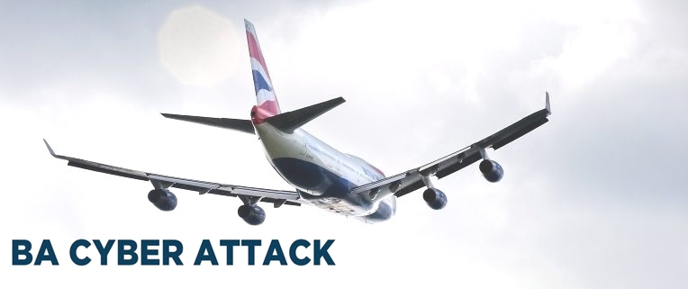
International airlines have also been a common goal for hackers. In 2017, the company BA was attacked after a widespread interruption in its computer systems that left stranded thousands of passengers for days. In April of this year, Delta Air Lines announced that one of its suppliers had been the victim of a data breach, while last week, Air Canada said that its mobile application had been violated, potentially affecting 20,000 people.

In May 2018, a PA Consulting report said that a hyperconnected model by which passengers at airports wanted fast Internet and digital engagement with airlines and retailers brought a larger attack surface for cybercriminals to exploit. There were 1,000 cyber attacks every month on aviation systems in 2016, according to the European Aviation Safety Agency.

Last year, Latam Airlines and Ukraine Boryspil Airport were hit indiscriminately by ransomware, and in 2016 Vietnam Airlines had to carry out its operations at airports by hand after the hackers canceled their website. A \ W


Ξ A I R G W A Y S Ξ
SOURCE:  Airgways.com
DBk: Ft.com / Reuters.com / Britishairways.com
AW-POST: 201809071107AR

A\W   A I R G W A Y S ®


Vuelo 5O-950 ASL Airlines en cuarentena

Resultado de imagen para ASL Airlines Boeing 737

AW | 2018 09 06 10:30 | AVIATION SAFETY

El vuelo de la aerolínea ASL Airlines aterrizó en el Aeropuerto de Perpiñán por sospecha de un caso de cólera

El Gobierno de Argelia dio por controlado la semana pasada el brote de cólera que ha matado a dos personas y dejado docenas de infectados en el país desde el 7 Agosto 2018. Unas 150 personas tuvieron que ser confinados en el avión en el que viajaban este miércoles desde Orán, Argelia, a su llegada al aeropuerto de Perpiñán, en el sur de Francia, a las 13:45 horas, debido a la sospecha de un caso de cólera detectado entre los pasajeros.

El vuelo 5O-950 a bordo de un Boeing 737 de ASL Airlines fue evacuado por temor a que un niño a bordo tuviera cólera altamente contagioso. Los 147 pasajeros y los miembros de la tripulación del avión de ASL Airlines no pudieron bajar del aparato que aterrizó en la ciudad del sur de Francia a las 13:45 horas, hasta que un médico les visitó.

Ante el riesgo de una epidemia de cólera, que se detectó en Argelia en agosto, las autoridades preferieron tomar todas las precauciones necesarias. Aunque no se descartó la sospecha de cólera, a los pasajeros se les permitió abandonar el avión sobre las 15 horas después de desinfectarse las manos.

El Gobierno de Argelia dio por controlado la semana pasada el brote de cólera que ha matado a dos personas y dejado docenas de infectados en el país desde su aparición, el pasado 7 de agosto. El ministro de Salud, Mokhtar Hasbellaoui, insistió en que la situación está completamente bajo control, y pronosticó que el brote sería erradicado en cuestión de días.

La Organización Mundial de la Salud (OMS) estima que el tiempo de incubación del cólera puede ser de hasta cinco días, pero que el vibrión responsable de la enfermedad puede permanecer hasta 10 días en portadores sanos.  AIRWAYS® AW-Icon TXT

Flight 5O-950 ASL Airlines in quarantine

The flight of the airline ASL Airlines landed at Perpignan Airport on suspicion of a case of cholera

The Algerian government last week took control of the outbreak of cholera that has killed two people and left dozens of people infected in the country since August 7, 2018. Some 150 people had to be confined on the plane they were traveling on Wednesday. from Oran, Algeria, on arrival at the airport in Perpignan, in the south of France, at 1:45 p.m., due to the suspicion of a cholera case detected among the passengers.

Flight 5O-950 aboard a Boeing 737 of ASL Airlines was evacuated for fear that a child on board would have highly contagious cholera. The 147 passengers and crew members of the ASL Airlines plane could not get off the aircraft that landed in the southern French city at 1:45 p.m., until a doctor visited them.

Given the risk of a cholera epidemic, which was detected in Algeria in August, authorities preferred to take all necessary precautions. Although the suspicion of cholera was not ruled out, passengers were allowed to leave the plane about 15 hours after disinfecting their hands.

The Algerian government last week took control of the outbreak of cholera that has killed two people and left dozens of infected in the country since its appearance on 7 August. Health Minister Mokhtar Hasbellaoui insisted that the situation is completely under control and predicted that the outbreak would be eradicated in a matter of days.

The World Health Organization (WHO) estimates that the incubation time of cholera can be up to five days, but that the vibrio responsible for the disease can remain up to 10 days in healthy carriers. A \ W


Ξ A I R G W A Y S Ξ
SOURCE:  Airgways.com
DBk: Aslairlines.fr
AW-POST: 201809061030AR

A\W   A I R G W A Y S ®

Vuelo A380 Emirates en cuarentena

Imagen relacionada

AW | 2018 09 05 20:50 | AVIATION SAFETY

Airbus A380 de Emirates Airlines fue puesto en cuarentena en el Aeropuerto JFK después de que 100 pasajeros se enfermaron

El vuelo EK203 de Emirates Airlines fue puesto en cuarentena en el Aeropuerto Internacional JFK de Nueva York después de que numerosos pasajeros se enfermaron a bordo. El número exacto de pasajeros y tripulación que se enfermó durante el vuelo sigue siendo inexacto. Alrededor de 100 pasajeros y tripulantes enfermaron y 11 necesitaron hospitalización. Sin embargo, Emirates informó que su recuento era de 19 pasajeros.

El vuelo EK203 aterrizó en el Aeropuerto Internacional JFK de Nueva York justo después de las 9 AM del miércoles, luego de un vuelo de 14 horas desde Dubai, Emiratos Árabes Unidos. La aeronave volvió al servicio el miércoles por la tarde como vuelo EK204 a Dubai.

AW-700000874

El vuelo EK203 de Emirates fue puesto en cuarentena en el Aeropuerto Internacional JFK de Nueva York después de que numerosos pasajeros se enfermaron a bordo. Los Centros para el Control y la Prevención de Enfermedades informaron que «aproximadamente 100 pasajeros, incluida una tripulación en el vuelo, se quejaron de enfermedad», pero luego corrigieron su declaración para decir que 11 pasajeros fueron trasladados a hospitales locales. La razón exacta de esta discrepancia significativa sigue sin estar clara. Inicialmente, Emirates dijo que el número de pasajeros enfermos era de aproximadamente 10, pero luego aumentó esa cifra a 19 personas, incluidos siete miembros de la tripulación.

La aerolínea confirmó que tres pasajeros y siete tripulantes fueron trasladados al hospital para recibir más atención médica y evaluación. Además, otros nueve pasajeros recibieron exámenes médicos adicionales en «un sitio cerca de la aeronave», pero luego fueron liberados, dijo Emirates. La causa de la enfermedad sigue siendo un misterio. Los pasajeros y la tripulación informaron síntomas como tos, fiebre y enfermedades gastrointestinales.

El vuelo de Emirates Airlines EK203, con un Airbus A380, aterrizó en Nueva York a las 09:18 AM del miércoles después de un viaje de 14 horas desde Dubai con 549 pasajeros y tripulación a bordo. Las imágenes publicadas en las redes sociales por los pasajeros muestran el avión en un puesto remoto rodeado por una armada de ambulancias y vehículos de respuesta a emergencias. Todos los pasajeros fueron evaluados por los funcionarios de salud antes de que los bajaran del avión.

La aeronave involucrada en el incidente, número de registro A6-EUF, regresó al servicio la tarde del miércoles como Emirates Flight EK204 a Dubai. AIRWAYS® AW-Icon TXT

Resultado de imagen para Emirates AirlineResultado de imagen para Emirates Airline

Emirates A380 flight in quarantine

Emirates Airlines Airbus A380 was quarantined at JFK Airport after 100 passengers became ill

Emirates Airlines flight EK203 was quarantined at New York’s JFK International Airport after numerous passengers became ill on board. The exact number of passengers and crew that became ill during the flight remains inaccurate. Around 100 passengers and crew fell ill and 11 needed hospitalization. However, Emirates reported that its count was 19 passengers.

Flight EK203 landed at the JFK International Airport in New York just after 9 AM on Wednesday, after a 14-hour flight from Dubai, United Arab Emirates. The aircraft returned to service on Wednesday afternoon as flight EK204 to Dubai.

Emirates flight EK203 was quarantined at New York’s JFK International Airport after numerous passengers became ill on board. The Centers for Disease Control and Prevention reported that «approximately 100 passengers, including a crew on the flight, complained of illness», but then corrected their statement to say that 11 passengers were transferred to local hospitals. The exact reason for this significant discrepancy remains unclear. Initially, Emirates said that the number of sick passengers was approximately 10, but then that figure increased to 19 people, including seven crew members.

The airline confirmed that three passengers and seven crew members were taken to the hospital for further medical attention and evaluation. In addition, nine other passengers received additional medical tests at «a site near the aircraft», but were later released, Emirates said. The cause of the disease remains a mystery. The passengers and crew reported symptoms such as cough, fever and gastrointestinal diseases.

AW-700000873

The Emirates Airlines flight EK203, with an Airbus A380, landed in New York at 09:18 AM on Wednesday after a 14-hour trip from Dubai with 549 passengers and crew on board. The images posted on social networks by passengers show the plane in a remote post surrounded by an army of ambulances and emergency response vehicles. All passengers were evaluated by health officials before they were taken off the plane.

The aircraft involved in the incident, registration number A6-EUF, returned to the service on Wednesday afternoon as Emirates Flight EK204 to Dubai. A \ W


Ξ A I R G W A Y S Ξ
SOURCE:  Airgways.com
DBk: Businessinsider.com / News.com.au / Usatoday.com / Abc7chicago.com
AW-POST: 201809052050AR

A\W   A I R G W A Y S ®

Huracán Florence azota Atlántico Norte

Resultado de imagen para Hurricane Florence

AW | 2018 09 05 19:00 | AVIATION SAFETY

1f300
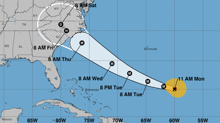
El huracán Florence se convierte en la primera gran tormenta de la temporada atlántica 2018

La sexta tormenta denominada Florence inicia la temporada de huracanes del Atlántico 2018 este miércoles para convertirse en el primer huracán importante del año. El Centro Nacional de Huracanes (NHC/NOAA) informó que el huracán Florence tiene vientos máximos sostenidos que se calculan en 125 mph, y está ubicado a unas 1.370 millas al este-sureste de Bermuda. Florence, ahora una tormenta de categoría 3, se mueve hacia el oeste-noroeste a 13 mph. «Un viraje hacia el oeste-noroeste con una disminución en la velocidad de avance se pronostica el jueves, seguido por un retroceso hacia el noroeste a principios de la próxima semana», dijo el NHC a su alerta a las 11 a.m. ET.

Una pista pronosticada por el NHC muestra que la tormenta eventualmente se dirigirá hacia el Atlántico central para el lunes. Es muy pronto para saber si la tormenta afectará alguna tierra, pero se les pide a los residentes y turistas en Bermudas que permanezcan vigilantes la próxima semana. «Es posible cierto debilitamiento durante los próximos días, pero se espera que Florencia siga siendo un fuerte huracán hasta principios de la próxima semana», dijo el NHC.

Florence llega mientras los residentes a lo largo de la costa del golfo están lidiando con los restos de la tormenta tropical Gordon, que tocó tierra el miércoles temprano. El huracán Florence es la sexta tormenta del año nombrada por la cuenca. El mes pasado, la Administración Nacional Oceánica y Atmosférica dijo que ahora se espera que la temporada de huracanes en el Atlántico sea menos activa al entrar en sus meses pico debido a una combinación de condiciones en el océano y la atmósfera que ayudan a limitar el desarrollo de tormentas.

Los pronosticadores de la NOAA ahora piden de 9 a 13 tormentas con vientos de 39 mph o más, de las cuales 4 a 7 se fortalecerán para convertirse en huracanes. De esas tormentas, puede haber hasta 2 huracanes mayores, que se clasifican como Categoría 3, 4 y 5 con vientos de 111 mph o más.  AIRWAYS® AW-Icon TXT


TRAYECTORIA DEL HURACÁN FLORENCE

gráfico de conoEste gráfico muestra una representación aproximada de las áreas costeras bajo una advertencia de huracán (roja), alerta de huracán (rosa), advertencia de tormenta tropical (azul) y reloj de tormenta tropical (amarillo). El círculo naranja indica la posición actual del centro del ciclón tropical. La línea negra, cuando se selecciona, y los puntos muestran la pista pronosticada del Centro Nacional de Huracanes (NHC) del centro en los horarios indicados. El punto que indica la ubicación del centro de pronóstico será negro si se pronostica que el ciclón será tropical y será blanco con un contorno negro si se pronostica que el ciclón será extratropical. Si solo se muestra una L, entonces se pronostica que el sistema será un mínimo remanente. La letra dentro del punto indica la intensidad del pronóstico del NHC para ese momento:

D : Depresión tropical – velocidad del viento inferior a 39 MPH
S : Tormenta tropical – velocidad del viento entre 39 MPH y 73 MPH
H : huracán – velocidad del viento entre 74 MPH y 110 MPH
M : huracán mayor – velocidad del viento superior a 110 MPH

Las pistas de previsión de ciclones tropicales de NHC pueden ser erróneas. Esta incertidumbre de pronóstico es transmitida por el «cono» de pronóstico de seguimiento, las áreas blancas sólidas y punteadas blancas en el gráfico. El área blanca sólida representa la incertidumbre del pronóstico de trayectoria para los días 1-3 del pronóstico, mientras que el área punteada muestra la incertidumbre en los días 4-5. Los datos históricos indican que la trayectoria completa de 5 días del centro del ciclón tropical permanecerá dentro del cono aproximadamente 60-70% del tiempo. Para formar el cono, se colocan un conjunto de círculos imaginarios a lo largo de la trayectoria pronosticada en las posiciones 12, 24, 36, 48, 72, 96 y 120 h, donde el tamaño de cada círculo se establece de modo que encierre el 67% de los errores de previsión oficiales de los últimos cinco años. El cono se forma conectando suavemente el área barrida por el conjunto de círculos.

También es importante darse cuenta de que un ciclón tropical no es un punto. Sus efectos pueden abarcar muchos cientos de millas desde el centro. El área que experimenta fuerza de huracán (viento promedio de un minuto de al menos 74 mph) y la fuerza de tormenta tropical (viento promedio de viento de un minuto de 39 a 73 mph) puede extenderse más allá de las áreas blancas que se muestran que encierran el área de pista más probable del centro La distribución de los vientos de huracanes y tormentas tropicales en este ciclón tropical se puede ver en el gráfico de Historia del viento vinculado anteriormente.

Teniendo en cuenta las incertidumbres del pronóstico combinado en seguimiento, intensidad y tamaño, las posibilidades de que un lugar en particular experimente vientos de 34 kt (fuerza de tormenta tropical), 50 kt o 64 kt (fuerza de huracán) de este ciclón tropical se presentan en forma de tabla para ubicaciones seleccionadas y posiciones pronosticadas . Esta información también se presenta en forma gráfica para los umbrales de 34 kt , 50 kt y 64 kt. A \ W


Resultado de imagen para Hurricane Florence

Hurricane Florence hits North Atlantic

Hurricane Florence becomes the first major storm of the Atlantic season 2018

The sixth storm named Florence begins the 2018 Atlantic hurricane season on Wednesday to become the first major hurricane of the year. The National Hurricane Center (NHC/NOAA) reported that Hurricane Florence has maximum sustained winds that are estimated at 125 mph, and is located about 1,370 miles east-southeast of Bermuda. Florence, now a Category 3 storm, moves west-northwest at 13 mph. «A shift to the west-northwest with a decrease in forward speed is forecast on Thursday, followed by a retreat to the northwest early next week», the NHC told its alert at 11 a.m. ET.

A runway predicted by the NHC shows that the storm will eventually head towards the central Atlantic by Monday. It is too early to tell if the storm will affect any land, but residents and tourists in Bermuda are asked to remain vigilant next week. «Some weakening is possible over the next few days, but Florence is expected to remain a strong hurricane until the beginning of next week», the NHC said.

Florence arrives while residents along the Gulf Coast are grappling with the remains of Tropical Storm Gordon, which made landfall early Wednesday. Hurricane Florence is the sixth storm of the year named by the basin. Last month, the National Oceanic and Atmospheric Administration said that hurricane season in the Atlantic is now expected to be less active as it enters its peak months due to a combination of conditions in the ocean and the atmosphere that help limit development of storms.

NOAA forecasters now call for 9 to 13 storms with winds of 39 mph or more, of which 4 to 7 will strengthen to become hurricanes. From those storms, there may be up to 2 major hurricanes, which are classified as Category 3, 4 and 5 with winds of 111 mph or more. A \ W

HURRICANE FLORENCE PATH

gráfico de conoThis graph shows an approximate representation of the coastal areas under a hurricane warning (red), hurricane alert (pink), tropical storm warning (blue) and tropical storm watch (yellow). The orange circle indicates the current position of the center of the tropical cyclone. The black line, when selected, and the points show the forecasted track of the center National Hurricane Center (NHC) at the indicated times. The point indicating the location of the forecast center will be black if it is predicted that the cyclone will be tropical and will be white with a black contour if the cyclone is predicted to be extratropical. If only one L is shown, then the system is predicted to be a minimum remaining. The letter within the point indicates the intensity of the NHC forecast for that moment:

D: Tropical depression – wind speed less than 39 MPH
S: Tropical storm – wind speed between 39 MPH and 73 MPH
H: hurricane – wind speed between 74 MPH and 110 MPH
M: major hurricane – wind speed greater than 110 MPH

The NHC tropical cyclone forecast tracks may be wrong. This forecast uncertainty is transmitted by the tracking forecast «cone», the solid white and dotted white areas in the graph. The solid white area represents the uncertainty of the trajectory forecast for days 1-3 of the forecast, while the dotted area shows the uncertainty on days 4-5. Historical data indicates that the full 5-day trajectory of the center of the tropical cyclone will remain within the cone approximately 60-70% of the time. To form the cone, a set of imaginary circles are placed along the predicted trajectory at positions 12, 24, 36, 48, 72, 96 and 120 h, where the size of each circle is set to enclose the 67% of the official forecast errors of the last five years. The cone is formed by gently connecting the area swept by the set of circles.

It is also important to realize that a tropical cyclone is not a point. Its effects can span many hundreds of miles from the center. The area experiencing hurricane force (average wind of at least 74 mph) and tropical storm force (average wind of one minute from 39 to 73 mph) can extend beyond the white areas shown that enclose the most likely track area of ​​the center The distribution of hurricane winds and tropical storms in this tropical cyclone can be seen in the Wind History chart linked above.

Taking into account the uncertainties of the combined forecast in tracking, intensity and size, the chances of a particular site experiencing winds of 34 kt (tropical storm force), 50 kt or 64 kt (hurricane force) of this tropical cyclone Present in a table form for selected locations and predicted positions. This information is also presented in graphic form for the thresholds of 34 kt, 50 kt and 64 kt. A \ W


Ξ A I R G W A Y S Ξ
SOURCE:  Airgways.com
DBk: Nhc.noaa.gov / Weather.com
AW-POST: 201809051900AR

A\W   A I R G W A Y S ®

Tormenta Gordon afecta EEUU

Resultado de imagen para Storm Tropical Gordon airport

AW | 2018 09 04 12:47 | AVIATION SAFETY

Las aerolíneas renuncian a las tarifas de cambio antes de la tormenta tropical Gordon

Las aerolíneas estaban renunciando a las tarifas de cambio antes de la Tormenta Tropical Gordon, que parecía llegar a tierra a lo largo de la costa del Golfo de Estados Unidos la noche del martes o la madrugada del miércoles.

Luego de cruzar el sur de la Florida el lunes, Gordon podría ser un huracán antes de trasladarse a tierra cerca de la frontera entre Luisiana y Mississippi, según proyecciones del Centro Nacional de Huracanes.

Gordon no tuvo un impacto significativo en los horarios de vuelo del lunes, y no estaba claro si eso cambiaría el martes cuando la tormenta se acercara a la costa del Golfo. No obstante, varias grandes aerolíneas, incluidas American, Delta y Southwest, habían renunciado a las tarifas de cambio el lunes por la noche para los aeropuertos en el camino de la tormenta.

Las exenciones climáticas permitieron a los viajeros hacer cambios, con letra pequeña, para intentar evitar la tormenta. Los detalles variaron según el operador, pero las políticas generalmente permitían a los clientes elegibles realizar un cambio sin pagar más. Solo los vuelos en ciertas fechas estaban cubiertos por las exenciones, y los detalles volvieron a variar según el operador.  AIRWAYS® AW-Icon TXT

Resultado de imagen para Storm Tropical Gordon

Storm Gordon affects the US

Airlines waive exchange rates before Tropical Storm Gordon

The airlines were waiving the exchange rates before Tropical Storm Gordon, which appeared to land ashore along the US Gulf Coast late Tuesday or early Wednesday.

After crossing south Florida on Monday, Gordon could be a hurricane before moving ashore near the Louisiana-Mississippi border, according to projections from the National Hurricane Center.

Gordon did not have a significant impact on Monday’s flight schedules, and it was not clear if that would change on Tuesday when the storm approached the Gulf Coast. However, several large airlines, including American, Delta and Southwest, had waived the exchange rates on Monday night for airports on the path of the storm.

The climate exemptions allowed travelers to make changes, with small print, to try to avoid the storm. The details varied by operator, but the policies generally allowed eligible customers to make a change without paying more. Only flights on certain dates were covered by the exemptions, and the details changed again according to the operator. A \ W


Ξ A I R G W A Y S Ξ
SOURCE:  Airgways.com
DBk: Noaa.gov / Miamidiario.com
AW-POST: 201809041247AR

A\W   A I R G W A Y S ®