
AW | 2020 11 02 15:00 | AVIATION SAFETY
Huracán Eta intensifica rápidamente a Categoría 4 en Centroamérica

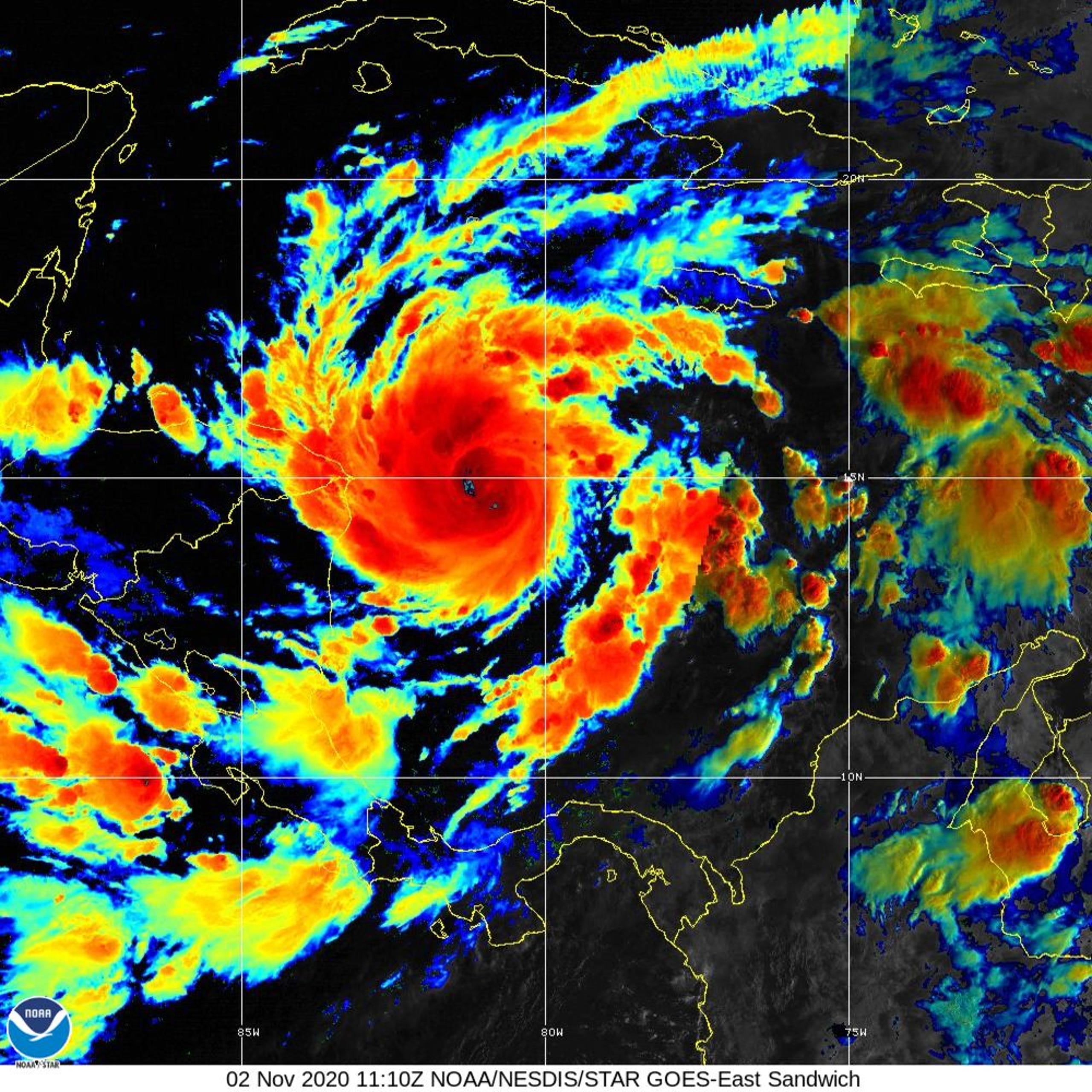
El Huracán Eta se intensifica rápidamente durante la noche del Domingo 01/11, impactando hacia el Lunes 02/11 trayendo marejadas muy violentas, fuertes vientos y casi 3 pies de lluvia. Podría provocar inundaciones catastróficas y deslizamientos de tierra en toda Centroamérica. Vientos sostenidos de Eta se fortalecieron a 110 mph lunes por la mañana. La tormenta se está moviendo hacia el oeste hacia Centroamérica a 9 mph, según un aviso del NHC emitido el Lunes 02/11 por la mañana. «Eta se ha convertido en un impresionante huracán de noviembre a medida que continúa experimentando un rápido fortalecimiento», dijo el Centro Nacional de Huracanes (NHC).
Se ha puesto en marcha una advertencia de huracanes para toda la costa de Nicaragua. Una advertencia de tormenta tropical está en vigor para la costa noreste de Honduras. Se espera que el centro de Eta se acerque a la costa noreste de Nicaragua el lunes por la tarde, y aterrice temprano el martes, antes de moverse hacia el interior sobre el norte de Nicaragua hasta principios del miércoles, según el NHC. El pronóstico actual tiene la tormenta serpenteando las montañas de Nicaragua y Honduras antes de dirigirse hacia el norte hacia Belice como depresión para el viernes. La pista y la intensidad de la tormenta sigue siendo incierta después del viernes y será vigilada de cerca.
Perspectivas Huracán Eta
El Huracán Eta es ahora la novena tormenta del año, y la quinta tormenta consecutiva, que se somete a una rápida intensificación, o el fortalecimiento de las velocidades del viento de 35 mph o más en 24 horas. La tormenta también producirá fuertes lluvias con estimaciones de 15 a 25 pulgadas, y cantidades aisladas de hasta 35 pulgadas en Nicaragua y Honduras. Se espera que la marejada de tormentas potencialmente mortal a lo largo de la costa de Nicaragua esté hasta 18 pies por encima de la marea normal. Los vientos extremadamente fuertes impactarán áreas de la costa hacia las montañas. Las fuertes lluvias se extenderán por toda Centroamérica, donde las áreas desde el sureste de México a través de Panamá pudieron ver acumulaciones de lluvia de hasta 25 pulgadas.
La amenaza de marejada de viento y tormenta disminuirá a lo largo del Martes 03/11, pero la lluvia durará hasta bien entrado el día de la semana. «Esta lluvia conduciría a inundaciones repentinas catastróficas y potencialmente mortales e inundaciones de ríos, junto con deslizamientos de tierra en áreas de terrenos más altos de Centroamérica. Las inundaciones repentinas y las inundaciones fluviales serían posibles en Jamaica, el sureste de México, El Salvador, el sur de Haití y las Islas Caimán», dijo el NHC.
El Huracán Eta es la 28a tormenta nombrada de la temporada activa de huracanes 2020 y empata el récord del número de tormentas nombradas en una sola temporada que se remonta en 2005. La tormenta tiene el potencial de ser uno de los peores eventos de inundación que Nicaragua ha visto desde el Huracán Mitch en 1998, que mató a más de 10.000 personas. ![]()
Hurricane Eta Category 4

Hurricane Eta rapidly escalates to Category 4 in Central America
Hurricane Eta intensifies rapidly during the night of Sunday 11/01, impacting towards Monday 11/02 bringing very violent swells, strong winds and almost 3 feet of rain. It could cause catastrophic floods and landslides throughout Central America. Sustained winds from Eta strengthened to 110 mph Monday morning. The storm is moving westward toward Central America at 9 mph, according to an NHC advisory issued Monday morning 02/11. «Eta has grown into an impressive November hurricane as it continues to experience rapid strengthening», said the National Hurricane Center (NHC).
A hurricane warning has been put in place for the entire Nicaraguan coast. A tropical storm warning is in effect for the northeast coast of Honduras. The center of Eta is expected to approach the northeast coast of Nicaragua Monday afternoon, landing early Tuesday, before moving inland over northern Nicaragua through early Wednesday, according to the NHC. The current forecast has the storm snaking through the mountains of Nicaragua and Honduras before heading north towards Belize as a depression for Friday. The track and intensity of the storm remains uncertain after Friday and will be closely watched.
Perspective Hurricane Eta
Hurricane Eta is now the ninth storm of the year, and the fifth storm in a row, to undergo rapid intensification, or strengthening of wind speeds of 35 mph or more in 24 hours. The storm will also produce heavy rains with estimates of 15 to 25 inches, and isolated amounts of up to 35 inches in Nicaragua and Honduras. The life-threatening storm surge along the Nicaraguan coast is expected to be up to 18 feet above normal tide. Extremely strong winds will impact coastal areas towards the mountains. Heavy rains will spread across Central America, where areas from southeastern Mexico through Panama could see rain accumulations of up to 25 inches.
The threat of storm surge and wind will diminish throughout Tuesday 11/03, but the rain will last well into the weekday. «This rain would lead to catastrophic and life-threatening flash floods and river flooding, along with landslides in higher ground areas of Central America. Flash floods and river flooding would be possible in Jamaica, southeastern Mexico, El Salvador, southern Haiti and the Cayman Islands», the NHC said.
Hurricane Eta is the 28th named storm of the 2020 active hurricane season and ties the record for the number of named storms in a single season dating back to 2005. The storm has the potential to be one of the worst flood events Nicaragua has seen since Hurricane Mitch in 1998, which killed more than 10,000 people.![]()

PUBLISHER: Airgways.com
DBk: Noaa.gov / Cnn.com / Airgways.com
AW-POST: 202011021500AR
A\W A I R G W A Y S ®
