 AW | 2019 08 26 10:37 | AVIATION SAFETY
 La tormenta tropical Dorian se agita al este de las Antillas Menores con probabilidades convertirse en huracán el Martes 27/08
La Tormenta Tropical Dorian espera que traiga condiciones de tormenta tropical a las Islas de Barlovento hoy Lunes 26 Agosto 2019 y que caiga hasta 4 pulgadas de lluvia sobre las islas, así como a Barbados y Dominica hasta para el Martes 27 Agosto 2019, según el Centro Nacional de Huracanes (NHC) del NOAA. Algunas áreas en Barbados y las Islas de Barlovento pueden ver hasta 6 pulgadas de lluvia, informó el centro. Hay advertencias de tormenta tropical para Barbados, Santa Lucía y San Vicente y las Granadinas hoy Lunes, y alertas de tormenta tropical para Dominica, Martinica y Granada y sus dependencias, dijo el centro. Las olas generadas por la tormenta alrededor de las Antillas Menores el Lunes podrían causar olas que pusieran en peligro a los ciudadanos.
Camino de Tormenta Dorian
La Tormenta Dorian es un «pequeño ciclón tropical», dijo el centro, con vientos de fuerza de tormenta tropical que se extienden hacia afuera hasta 45 millas desde su centro. Más tarde el lunes, ese centro estará cerca de las Islas de Barlovento. La tormenta se intensificará cuando llegue al oeste, pasando las Antillas Menores y hacia el Mar Caribe el Martes. Los vientos máximos sostenidos de Dorian han subido hasta 60 mph, dijo el centro, y se espera que se fortalezcan lentamente. «Dorian podría estar cerca de la fuerza del huracán el martes y miércoles mientras está sobre el este del Mar Caribe», dijo el centro.
Dorian es una tormenta compacta, lo que hace que el pronóstico sea más difícil, especialmente cuando se trata de intensidad. A medida que avanza hacia el oeste, estará luchando contra la cizalladura del viento y el aire seco, dos asesinos de huracanes. Modelos confiables muestran que la tormenta se debilita y se disipa antes de llegar a Puerto Rico y La Española. Si la tormenta logra superar las condiciones hostiles y se intensifica, tanto Puerto Rico como República Dominicana enfrentarán una amenaza de huracán a mitad de semana, con intensidad de vientos, fuertes inundaciones y amenazas de deslizamientos de tierra en terrenos más altos.
Dorian ¿hacia Categoría 1?
Se espera que la tormenta tropical de esta semana se convierta en un huracán de Categoría 1 (CAT 1) mientras esté cerca de Puerto Rico. Dorian, la cuarta tormenta nombrada de la temporada de huracanes, se acercará a Puerto Rico el Miércoles 28/08 por la noche. Los puertorriqueños, con nuevos recuerdos del desastre de 2017, se han estado preparando para la apariencia de Dorian. Hace casi dos años, la isla fue azotada por el Huracán María, que desencadenó la muerte y la devastación y dejó a casi toda la isla sin electricidad.
El Centro Nacional de Huracanes dice que si bien es demasiado pronto para determinar la magnitud o los posibles impactos de Dorian en Puerto Rico, las Islas Vírgenes o La Española, esas áreas deben continuar monitoreando el progreso de la tormenta. En general, la temporada de huracanes alcanza un pico en las ocho semanas alrededor del 10 de septiembre. Dos tercios de todas las tormentas producidas en una temporada típica ocurren durante este período.![]()
 Dorian Tropical Storm
Tropical storm Dorian stirs east of the Lesser Antilles with a chance to become a hurricane on Tuesday 27/08
Tropical Storm Dorian expects that it will bring tropical storm conditions to the Windward Islands today Monday, August 26, 2019 and that up to 4 inches of rain will fall on the islands, as well as to Barbados and Dominica until Tuesday, August 27, 2019, according to the Center National Hurricane (NHC) of NOAA. Some areas in Barbados and the Windward Islands can see up to 6 inches of rain, the center said. There are tropical storm warnings for Barbados, Saint Lucia and Saint Vincent and the Grenadines today Monday, and tropical storm alerts for Dominica, Martinique, and Grenada and their dependencies, the center said. The waves generated by the storm around the Lesser Antilles on Monday could cause waves that endanger citizens.
Dorian Storm Road
Dorian Storm is a «small tropical cyclone,» the center said, with winds of tropical storm force extending outward up to 45 miles from its center. Later on Monday, that center will be near the Windward Islands. The storm will intensify when it reaches the west, passing the Lesser Antilles and into the Caribbean Sea on Tuesday. Dorian’s maximum sustained winds have risen to 60 mph, the center said, and are expected to strengthen slowly. «Dorian could be near the force of the hurricane on Tuesday and Wednesday while it is over the eastern Caribbean Sea», the center said.
Dorian is a compact storm, which makes the forecast more difficult, especially when it comes to intensity. As you move west, you will be fighting the wind shear and dry air, two hurricane killers. Reliable models show that the storm weakens and dissipates before arriving in Puerto Rico and Hispaniola. If the storm manages to overcome hostile conditions and intensifies, both Puerto Rico and the Dominican Republic will face a hurricane threat in the middle of the week, with high winds, heavy floods and threats of landslides on higher ground.
Dorian towards Category 1?
This week’s tropical storm is expected to become a Category 1 (CAT 1) hurricane while it is near Puerto Rico. Dorian, the fourth named storm of the hurricane season, will approach Puerto Rico on Wednesday, 08/28 at night. Puerto Ricans, with new memories of the 2017 disaster, have been preparing for Dorian’s appearance. Almost two years ago, the island was hit by Hurricane Maria, which triggered death and devastation and left almost the entire island without electricity.
The National Hurricane Center says that while it is too early to determine the magnitude of potential impacts of Dorian in Puerto Rico, the Virgin Islands or Hispaniola, those areas should continue to monitor the progress of the storm. In general, hurricane season peaks in the eight weeks around September 10. Two-thirds of all storms produced in a typical season occur during this period. A \ W
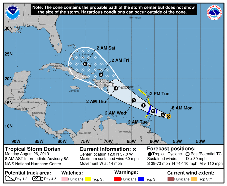
000 WTNT35 KNHC 261138 TCPAT5 BOLETÍN Tormenta tropical Dorian Número intermedio de asesoramiento 8A NWS National Hurricane Center Miami FL AL052019 800 AM AST lun 26 de ago de 2019 ... DORIAN COMPACTO MEJORANDO MEJOR ORGANIZADO ... ... SE ESPERA QUE TRAER CONDICIONES DE TORMENTA TROPICAL AL VIENTO ISLAS MÁS TARDE HOY ... RESUMEN DE 800 AM AST ... 1200 UTC ... INFORMACIÓN ---------------------------------------------- UBICACIÓN ... 12.0N 57.0W ACERCA DE 205 MI ... 330 KM ESE DE BARBADOS ACERCA DE 315 MI ... 505 KM ESE DE ST. LUCIA VIENTOS MÁXIMOS SOSTENIDOS ... 60 MPH ... 95 KM / H MOVIMIENTO ACTUAL ... W O 280 GRADOS A 14 MPH ... 22 KM / H PRESIÓN CENTRAL MÍNIMA ... 1002 MB ... 29.59 PULGADAS RELOJES Y ADVERTENCIAS -------------------- CAMBIOS CON ESTA ADVERTENCIA: Ninguna. RESUMEN DE RELOJES Y ADVERTENCIAS EN EFECTO: Una advertencia de tormenta tropical está vigente para ... * Barbados * Santa Lucía * San Vicente y las Granadinas Una vigilancia de tormenta tropical está vigente para ... * Dominica * Martinica * Granada y sus dependencias * Saba y San Eustaquio Una advertencia de tormenta tropical significa que las condiciones de tormenta tropical son esperado en algún lugar dentro del área de advertencia dentro de las 36 horas. Una vigilancia de tormenta tropical significa que las condiciones de tormenta tropical son posible dentro del área de vigilancia, generalmente dentro de las 48 horas. Los intereses en Puerto Rico, las Islas Vírgenes y la Española deberían monitorear el progreso de Dorian ya que los relojes podrían ser necesarios como temprano como más tarde hoy. Para obtener información sobre tormentas específica de su área, controle productos emitidos por su servicio meteorológico nacional. DISCUSIÓN Y PERSPECTIVAS ---------------------- A las 800 AM AST (1200 UTC), el centro de la tormenta tropical Dorian estaba ubicado cerca de la latitud 12.0 norte, longitud 57.0 oeste. Dorian es moviéndose hacia el oeste cerca de 14 mph (22 km/h). Un giro hacia el oeste-noroeste se espera más tarde hoy, con esta moción continua hasta el martes por la noche. En la pista del pronóstico, el centro de Dorian se espera que esté cerca de las Islas de Barlovento tarde hoy y esta noche y mudarse al este del Mar Caribe el martes. Los vientos máximos sostenidos son cerca de 60 mph (95 km/h) con ráfagas más altas. Se pronostica cierto fortalecimiento durante los próximos días, y Dorian podría estar cerca de la fuerza del huracán el martes y miércoles mientras se mueve sobre el mar Caribe oriental. Dorian es un pequeño ciclón tropical. Vientos con fuerza de tormenta tropical solo se extienden hacia afuera hasta 45 millas (75 km) desde el centro. La presión central mínima estimada es de 1002 mb (29.59 pulgadas). PELIGROS QUE AFECTAN LA TIERRA ---------------------- LLUVIA: Se espera que Dorian produzca acumulaciones totales de lluvia de 2 a 4 pulgadas en Barbados, las Islas de Barlovento y Dominica hasta el martes Son posibles cantidades máximas aisladas de 6 pulgadas en Barbados y las Islas de Barlovento. VIENTO: es probable que las condiciones de tormenta tropical en el área de advertencia por hoy más tarde. Las condiciones de tormenta tropical son posibles dentro del vigilar el área esta noche o martes. SURF: las olas generadas por Dorian afectarán porciones de Antillas Menores por hoy tarde. Estas olas podrían causar vida. amenazando las condiciones actuales de surf y rip. Por favor consulta productos de su oficina meteorológica local. PRÓXIMA ADVERTENCIA ------------- Siguiente aviso completo a las 11:00 AM AST.
000
WTNT35 KNHC 261138
TCPAT5

BULLETIN
Tropical Storm Dorian Intermediate Advisory Number 8A
NWS National Hurricane Center Miami FL       AL052019
800 AM AST Mon Aug 26 2019

...COMPACT DORIAN GETTING BETTER ORGANIZED...
...EXPECTED TO BRING TROPICAL STORM CONDITIONS TO THE WINDWARD
ISLANDS LATER TODAY...


SUMMARY OF 800 AM AST...1200 UTC...INFORMATION
----------------------------------------------
LOCATION...12.0N 57.0W
ABOUT 205 MI...330 KM ESE OF BARBADOS
ABOUT 315 MI...505 KM ESE OF ST. LUCIA
MAXIMUM SUSTAINED WINDS...60 MPH...95 KM/H
PRESENT MOVEMENT...W OR 280 DEGREES AT 14 MPH...22 KM/H
MINIMUM CENTRAL PRESSURE...1002 MB...29.59 INCHES


WATCHES AND WARNINGS
--------------------
CHANGES WITH THIS ADVISORY:

None.

SUMMARY OF WATCHES AND WARNINGS IN EFFECT:

A Tropical Storm Warning is in effect for...
* Barbados
* St. Lucia
* St. Vincent and the Grenadines

A Tropical Storm Watch is in effect for...
* Dominica
* Martinique
* Grenada and its dependencies
* Saba and St. Eustatius

A Tropical Storm Warning means that tropical storm conditions are
expected somewhere within the warning area within 36 hours.

A Tropical Storm Watch means that tropical storm conditions are
possible within the watch area, generally within 48 hours.

Interests in Puerto Rico, the Virgin Islands, and Hispaniola should
monitor the progress of Dorian as watches could be required as
early as later today.

For storm information specific to your area, please monitor
products issued by your national meteorological service.


DISCUSSION AND OUTLOOK
----------------------
At 800 AM AST (1200 UTC), the center of Tropical Storm Dorian was
located near latitude 12.0 North, longitude 57.0 West.  Dorian is
moving toward the west near 14 mph (22 km/h). A turn toward the
west-northwest is expected later today, with this motion continuing
through Tuesday night.  On the forecast track, the center of Dorian
is expected to be near the Windward Islands late today and tonight
and move into the eastern Caribbean Sea on Tuesday.

Maximum sustained winds are near 60 mph (95 km/h) with higher gusts.
Some strengthening is forecast during the next few days, and Dorian
could be near hurricane strength on Tuesday and Wednesday while it
moves over the eastern Caribbean Sea.

Dorian is a small tropical cyclone.  Tropical-storm-force winds
only extend outward up to 45 miles (75 km) from the center.

The estimated minimum central pressure is 1002 mb (29.59 inches).


HAZARDS AFFECTING LAND
----------------------
RAINFALL:  Dorian is expected to produce total rain accumulations of
2 to 4 inches in Barbados, the Windward Islands, and Dominica
through Tuesday.  Isolated maximum amounts of 6 inches are possible
in Barbados and the Windward Islands.

WIND:  Tropical storm conditions are likely in the warning area by
late today.  Tropical storm conditions are possible within the
watch area by tonight or Tuesday.

SURF:  Swells generated by Dorian will be affecting portions of the
Lesser Antilles by late today. These swells could cause life-
threatening surf and rip current conditions.  Please consult
products from your local weather office.


NEXT ADVISORY
-------------
Next complete advisory at 1100 AM AST.

$$
Forecaster Stewart
TRINIDAD & TOBAGO WEATHER

DATA: La información procesada puede actualizarse debido al tipo de datos cambiantes, por lo que le sugerimos consultar periódicamente esta información.
DATA: The processed information can be updated due to the type of changing data, so we suggest you consult this information periodically.
Ξ A I R G W A Y S Ξ
SOURCE: Airgways.com
DBk: Noaa.gov / Weather.com / Ttweathercenter.com / Express.co.uk
AW-POST: 201908261037AR
A\W A I R G W A Y S ®
