Huracán Dorian | Día 05/09
 AW | 2019 09 05 23:29 | AVIATION SAFETY
 El Huracán Dorian azota los estados de las Carolinas
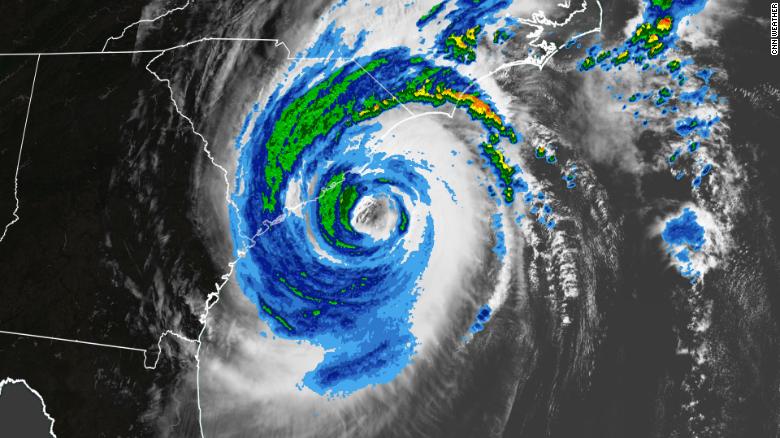
El Huracán Dorian se ha intensificado, con vientos de tormenta tropical y vientos huracanados que cubren más territorio. El huracán Dorian azotó a las Carolinas hoy Jueves 05/09, entregando una poderosa combinación de viento y lluvia y parece probable que golpee a los estados hasta el mediodía del Viernes.
El Jueves por la noche, la pared del ojo del huracán Dorian, donde la tormenta es más devastadora, estaba a solo 50 millas de la costa deL Estado del Sur Carolina, paralela a Myrtle Beach. Esta era la hora que más preocupaban a los funcionarios, cuando los pronósticos anteriores habían advertido sobre un posible aterrizaje y una tormenta eléctrica masiva casi segura. El ciclón se enfureció provocando olas agitadas que asolaron las playas y el agua del océano se derramó sobre las barreras de arena; los vientos derribaron árboles y líneas eléctricas, dejando a miles sin electricidad; y las fuertes lluvias inundaron las carreteras e hicieron que conducir fuera peligroso. Pero esta franja costera de Carolina del Sur, conocida como Grand Strand, esperaba mucho peor.
Los funcionarios aún están preocupados por las inundaciones, especialmente alrededor del río Waccamaw en Conway, pero incluso allí, la proyección, que alcanza los 14 pies, es significativamente menor que el récord de 21 pies establecido allí en 2018 durante el Huracán Florencia. Duke Energy reportó a las 8 pm, más de 29.000 clientes sin electricidad en la costa de Carolina del Norte, extendiéndose al noreste de Carolina del Sur.
La oficina de pronóstico de Wilmington del Servicio Meteorológico Nacional ha informado que el Jueves se han reportado varios tornados confirmados en los condados costeros de Carolina del Norte y del Sur, de siete a 12 pulgadas de lluvia han empapado la costa de Carolina del Sur y han caído de seis a ocho pulgadas de lluvia en New Hanover de Wilmington Condado y el condado contiguo de Pender. Son posibles de tres a seis pulgadas adicionales durante la noche. «Las inundaciones repentinas y los cortes de energía son las principales preocupaciones, ya que la amenaza de tornado ya no existe. La marejada ciclónica también sigue siendo una preocupación durante la marea alta de esta noche, especialmente para Carolina del Norte», dijo el boletín de servicio.
Pronóstico extendido
La marea alta en Wrightsville Beach, directamente al este de Wilmington, es a las 01:27 am del Viernes 06/09, justo cuando se espera que aumenten los vientos huracanados. El centro de Dorian puede moverse cerca o sobre la costa de Carolina del Norte el viernes temprano antes de hacer una salida más rápida hacia el océano Atlántico. Si golpea a Carolina del Norte después de recuperar fuerzas nuevamente, sería el primer huracán de categoría 3 en golpear al estado desde 1996.
Los pronosticadores detallaron un alto riesgo de inundaciones repentinas en las costas de Carolina del Norte y del Sur y un riesgo moderado de inundaciones repentinas en Virginia. El jueves se vieron tornados en las Carolinas debido a los fuertes vientos de Dorian.
Efectos en Bahamas
Miles de personas se encuentran desaparecidas después de que la tormenta azotara las Bahamas, donde el número de muertos ha aumentado a 30 personas. El Huracán Dorian estuvo empatado en el segundo huracán más poderoso por la velocidad del viento en la cuenca del Atlántico desde 1851 detrás del huracán Allen en 1980 con vientos de 190 mph. El número de muertos en las Bahamas ha aumentado a alrededor de 30 y se espera que aumente a medida que continúen las operaciones de búsqueda y rescate.![]()
 Hurricane Dorian | Day 05/09
Hurricane Dorian strikes the states of the Carolinas
Hurricane Dorian has intensified, with tropical storm winds and hurricane winds that cover more territory. Hurricane Dorian hit the Carolinas today Thursday 05/09, delivering a powerful combination of wind and rain and seems likely to hit the states until noon on Friday.
On Thursday night, the eyewall of Hurricane Dorian, where the storm is most devastating, was only 50 miles off the coast of the State of South Carolina, parallel to Myrtle Beach. This was the time that officials worried most when previous forecasts had warned of a possible landing and an almost certain massive electrical storm. The cyclone was enraged causing rough waves that ravaged the beaches and ocean water spilled over the sand barriers; winds knocked down trees and power lines, leaving thousands without electricity; and heavy rains flooded the roads and made driving dangerous. But this coastal strip of South Carolina, known as Grand Strand, expected much worse.
Officials are still worried about flooding, especially around the Waccamaw River in Conway, but even there, the projection, which reaches 14 feet, is significantly lower than the 21-foot record set there in 2018 during Hurricane Florence. Duke Energy reported at 8 pm, more than 29,000 customers without power on the North Carolina coast, extending to northeastern South Carolina.
The Wilmington National Meteorological Service forecasting office has reported that on Thursday several confirmed tornadoes have been reported in the coastal counties of North and South Carolina, seven to 12 inches of rain have soaked the coast of South Carolina and have six to eight inches of rain fell in New Hanover of Wilmington County and the adjoining Pender County. An additional three to six inches are possible overnight. «Flash floods and power outages are the main concerns, as the tornado threat no longer exists. The storm surge also remains a concern at high tide tonight, especially for North Carolina», the bulletin said. of service.
Extended forecast
High tide at Wrightsville Beach, directly east of Wilmington, is at 01:27 am on Friday 06/09, just when hurricane winds are expected to rise. Downtown Dorian can move near or over the North Carolina coast early Friday before making a faster exit to the Atlantic Ocean. If it hits North Carolina after regaining strength again, it would be the first category 3 hurricane to hit the state since 1996.
Forecasters detailed a high risk of flash flooding along the coasts of North and South Carolina and a moderate risk of flash flooding in Virginia. On Thursday, tornadoes were seen in the Carolinas due to the strong winds of Dorian.
Effects in the Bahamas
Thousands of people are missing after the storm hit the Bahamas, where the death toll has increased to 30 people. Hurricane Dorian was tied for the second most powerful hurricane by wind speed in the Atlantic basin since 1851 behind Hurricane Allen in 1980 with 190 mph winds. The death toll in the Bahamas has increased to around 30 and is expected to increase as search and rescue operations continue. A \ W

Asesor Público del Huracán Dorian
000
WTNT35 KNHC 060008 CCA
TCPAT5

BOLETÍN
Huracán Dorian Número de aviso intermedio 50A ... corregido
NWS National Hurricane Center Miami FL AL052019
800 PM EDT jue 05 sep 2019

Corregido para agregar advertencia de tormenta tropical desde la playa de Edisto al sur
Río santee

... MURO DE DORIAN MUY CERCA DE CAPE FEAR NORTE DE CAROLINA ...


RESUMEN DE 800 PM EDT ... 0000 UTC ... INFORMACIÓN
----------------------------------------------
UBICACIÓN ... 33.4N 78.0W
ACERCA DE 30 MI ... 50 KM S DE CAPE FEAR NORTE DE CAROLINA
ACERCA DE 60 MI ... 95 KM KM S DE WILMINGTON NORTH CAROLINA
VIENTOS MÁXIMOS SOSTENIDOS ... 100 MPH ... 160 KM / H
MOVIMIENTO ACTUAL ... NE O 35 GRADOS A 10 MPH ... 17 KM / H
PRESIÓN CENTRAL MÍNIMA ... 964 MB ... 28.47 PULGADAS


RELOJES Y ADVERTENCIAS
--------------------
CAMBIOS CON ESTA ADVERTENCIA:

La advertencia de marejada ciclónica se suspendió al oeste de Cape Fear.

La advertencia de huracán desde Edisto Beach SC hasta South Santee
El río ha cambiado a Advertencia de tormenta tropical.

La advertencia de tormenta tropical al sur de Edisto Beach ha sido
interrumpido.

RESUMEN DE RELOJES Y ADVERTENCIAS EN EFECTO:

Una advertencia de marejada ciclónica está vigente para ...
* Cape Fear to Poquoson VA
* Sonidos Pamlico y Albemarle
* Neuse y Pamlico Rivers
* Hampton Roads

Una advertencia de huracán está vigente para ...
* South Santee River hasta la frontera de Carolina del Norte / Virginia
* Sonidos Pamlico y Albemarle

Una advertencia de tormenta tropical está vigente para ...
* Playa Edisto al río South Santee
* Frontera de Carolina del Norte / Virginia con la isla Fenwick DE
* Bahía de Chesapeake desde Drum Point hacia el sur
* Tidal Potomac al sur de la isla de Cobb
* Woods Hole a Sagamore Beach MA
* Nantucket y Martha's Vineyard MA

Una advertencia de marejada ciclónica significa que existe el peligro de poner en peligro la vida
inundación, por el aumento del agua que se mueve tierra adentro desde la costa,
durante las siguientes 36 horas en los lugares indicados. Para una representación
de áreas en riesgo, consulte la Tormenta del Servicio Meteorológico Nacional
Alerta de sobretensión / Gráfico de advertencia, disponible en hurricanes.gov. Esto es un
situación que amenaza la vida. Personas ubicadas dentro de estas áreas
debe tomar todas las medidas necesarias para proteger la vida y la propiedad de
aumento del agua y la posibilidad de otras condiciones peligrosas.
Siga inmediatamente la evacuación y otras instrucciones del local
funcionarios

Una advertencia de huracán significa que se esperan condiciones de huracán
en algún lugar dentro del área de advertencia. Preparativos para proteger la vida y
La propiedad debe ser apresurada para su finalización.

Una advertencia de tormenta tropical significa que las condiciones de tormenta tropical son
esperado dentro del área de advertencia dentro de las 36 horas.

Intereses en otras partes de las costas del Atlántico medio y Nueva Inglaterra de
los Estados Unidos y el Atlántico de Canadá deberían continuar monitoreando
El progreso de Dorian.

Para información sobre tormentas específica de su área, incluyendo posibles
relojes y advertencias interiores, controle los productos emitidos por su
oficina local de pronóstico del Servicio Meteorológico Nacional.


DISCUSIÓN Y PERSPECTIVAS
----------------------
A las 800 PM EDT (0000 UTC), se localizó el ojo del huracán Dorian
cerca de la latitud 33.4 norte, longitud 78.0 oeste. Dorian se está moviendo
hacia el noreste cerca de 10 mph (17 km / h), y este movimiento general
se espera que continúe con un aumento en la velocidad de avance a través de
Sábado. En la pista del pronóstico, el centro de Dorian se moverá
cerca o sobre la costa de Carolina del Norte esta noche y viernes. los
centro debe moverse hacia el sureste del extremo sureste Nuevo
Inglaterra el viernes por la noche y el sábado por la mañana, y acércate a Nueva Escocia
más tarde el sábado o el sábado por la noche.

Informes de un avión de la Reserva de la Fuerza Aérea Hurricane Hunter
indican que los vientos máximos sostenidos ahora están cerca de 100 mph (160
km / h) con ráfagas más altas. Se espera un debilitamiento lento durante el próximo
Pocos diás. Sin embargo, se espera que Dorian siga siendo un poderoso huracán.
a medida que el centro se mueve cerca de las costas de Carolina del Sur y del Norte.
Se pronostica que Dorian se convertirá en un ciclón post-tropical con fuerza de huracán
para el sábado por la noche cuando se acerque a Nueva Escocia.

Los vientos huracanados se extienden hacia afuera hasta 60 millas (95 km) desde
el centro y los vientos con fuerza de tormenta tropical se extienden hacia afuera hasta 220
millas (350 km). Sartén Shoals acaba de informar una ráfaga máxima de 70
mph (113 km / h).

La presión central mínima basada en aviones Hurricane Hunter
los datos son 964 mb (28.47 pulgadas).


PELIGROS QUE AFECTAN LA TIERRA
----------------------
VIENTO: las condiciones de huracán comienzan a extenderse a lo largo de porciones
de la costa de Carolina del Norte. Las condiciones de tormenta tropical todavía están
afectando la porción norte de la costa de Carolina del Sur.

Se esperan condiciones de tormenta tropical en la tormenta tropical
Área de advertencia en los estados del Atlántico medio para el viernes y más
porciones del extremo sureste de Massachusetts a última hora del viernes o
temprano el sábado

Oleada de tormenta: la combinación de una marejada peligrosa y el
la marea hará que las zonas normalmente secas cercanas a la costa se inunden
crecientes aguas que se mueven tierra adentro desde la costa. El agua podría
alcanzar las siguientes alturas sobre el suelo en algún lugar de lo indicado
áreas si la marejada ocurre en el momento de la marea alta ...

Cape Fear to Duck NC, incluidos Pamlico y Albemarle
Sonidos y los ríos Neuse y Pamlico ... 4 a 7 pies
Duck NC a Poquoson VA, incluyendo Hampton Roads ... 2 a 4 pies

Los niveles de agua podrían comenzar a elevarse mucho antes de la llegada de
vientos fuertes. La oleada irá acompañada de grandes y
olas destructivas Las inundaciones relacionadas con oleadas dependen de qué tan cerca
el centro de Dorian llega a la costa y puede variar mucho
distancias cortas. Para obtener información específica de su área, consulte
productos emitidos por su pronóstico local del Servicio Meteorológico Nacional
oficina.

LLUVIA: Se espera que Dorian produzca la siguiente lluvia
totales hasta el viernes:

Carolinas costeras ... 6 a 12 pulgadas, aisladas 15 pulgadas
Lejano sureste de Virginia ... 3 a 8 pulgadas
Extremo sureste de Nueva Inglaterra ... 2 a 4 pulgadas

Esta lluvia puede causar inundaciones repentinas que amenazan la vida.

SURF: grandes olas afectarán el noroeste de Bahamas, y
toda la costa sureste de los Estados Unidos desde Florida hasta
Carolina del Norte durante los próximos días. Estas olas son
Es probable que provoque surf y rasgue las condiciones actuales.
Consulte los productos de su oficina meteorológica local.

TORNADOS: Los tornados son posibles hasta el viernes temprano en
este de Carolina del Norte hacia el sureste de Virginia.


PRÓXIMA ADVERTENCIA
-------------
Siguiente aviso completo a las 1100 PM EDT.

$$
Pronosticador Ávila
Hurricane Dorian Public Advisory
000
WTNT35 KNHC 060008 CCA
TCPAT5

BULLETIN
Hurricane Dorian Intermediate Advisory Number 50A...Corrected
NWS National Hurricane Center Miami FL       AL052019
800 PM EDT Thu Sep 05 2019

Corrected to add Tropical Storm Warning from Edisto Beach to South
Santee River

...EYEWALL OF DORIAN VERY NEAR CAPE FEAR NORTH CAROLINA...


SUMMARY OF 800 PM EDT...0000 UTC...INFORMATION
----------------------------------------------
LOCATION...33.4N 78.0W
ABOUT 30 MI...50 KM S OF CAPE FEAR NORTH CAROLINA
ABOUT 60 MI...95 KM KM S OF WILMINGTON NORTH CAROLINA
MAXIMUM SUSTAINED WINDS...100 MPH...160 KM/H
PRESENT MOVEMENT...NE OR 35 DEGREES AT 10 MPH...17 KM/H
MINIMUM CENTRAL PRESSURE...964 MB...28.47 INCHES


WATCHES AND WARNINGS
--------------------
CHANGES WITH THIS ADVISORY:

The Storm Surge Warning has been discontinued west of Cape Fear.

The Hurricane Warning from Edisto Beach SC to the South Santee
River has been changed to Tropical Storm Warning.

The Tropical Storm Warning south of Edisto Beach has been
discontinued.

SUMMARY OF WATCHES AND WARNINGS IN EFFECT:

A Storm Surge Warning is in effect for...
* Cape Fear to Poquoson VA
* Pamlico and Albemarle Sounds
* Neuse and Pamlico Rivers
* Hampton Roads

A Hurricane Warning is in effect for...
* South Santee River to the North Carolina/Virginia border
* Pamlico and Albemarle Sounds

A Tropical Storm Warning is in effect for...
* Edisto Beach to South Santee River
* North Carolina/Virginia border to Fenwick Island DE
* Chesapeake Bay from Drum Point southward
* Tidal Potomac south of Cobb Island
* Woods Hole to Sagamore Beach MA
* Nantucket and Martha's Vineyard MA

A Storm Surge Warning means there is a danger of life-threatening
inundation, from rising water moving inland from the coastline,
during the next 36 hours in the indicated locations. For a depiction
of areas at risk, please see the National Weather Service Storm
Surge Watch/Warning Graphic, available at hurricanes.gov.  This is a
life-threatening situation.  Persons located within these areas
should take all necessary actions to protect life and property from
rising water and the potential for other dangerous conditions.
Promptly follow evacuation and other instructions from local
officials.

A Hurricane Warning means that hurricane conditions are expected
somewhere within the warning area.  Preparations to protect life and
property should be rushed to completion.

A Tropical Storm Warning means that tropical storm conditions are
expected within the warning area within 36 hours.

Interests elsewhere along the Mid-Atlantic and New England coasts of
the United States, and Atlantic Canada, should continue to monitor
the progress of Dorian.

For storm information specific to your area, including possible
inland watches and warnings, please monitor products issued by your
local National Weather Service forecast office.


DISCUSSION AND OUTLOOK
----------------------
At 800 PM EDT (0000 UTC), the eye of Hurricane Dorian was located
near latitude 33.4 North, longitude 78.0 West.  Dorian is moving
toward the northeast near 10 mph (17 km/h), and this general motion
is expected to continue with an increase in forward speed through
Saturday.  On the forecast track, the center of Dorian will move
near or over the coast of North Carolina tonight and Friday. The
center should move to the southeast of extreme southeastern New
England Friday night and Saturday morning, and approach Nova Scotia
later Saturday or Saturday night.

Reports from an Air Force Reserve Hurricane Hunter aircraft
indicate that maximum sustained winds are now near 100 mph (160
km/h) with higher gusts.  Slow weakening is expected during the next
few days. However, Dorian is expected to remain a powerful hurricane
as the center moves near the coasts of South and North Carolina.
Dorian is forecast to become a hurricane-force post-tropical cyclone
by Saturday night as it approaches Nova Scotia.

Hurricane-force winds extend outward up to 60 miles (95 km) from
the center and tropical-storm-force winds extend outward up to 220
miles (350 km). Frying Pan Shoals just reported a peak gust of 70
mph (113 km/h).

The minimum central pressure based on Hurricane Hunter aircraft
data is 964 mb (28.47 inches).


HAZARDS AFFECTING LAND
----------------------
WIND:  Hurricane conditions are beginning to spread along portions
of the North Carolina coast. Tropical storm conditions are still
affecting the northern portion of the South Carolina coast.

Tropical storm conditions are expected in the Tropical Storm
Warning area in the Mid-Atlantic states by Friday and over
portions of extreme southeastern Massachusetts by late Friday or
early Saturday.

STORM SURGE:  The combination of a dangerous storm surge and the
tide will cause normally dry areas near the coast to be flooded by
rising waters moving inland from the shoreline.  The water could
reach the following heights above ground somewhere in the indicated
areas if the peak surge occurs at the time of high tide...

Cape Fear to Duck NC, including Pamlico and Albemarle
Sounds and the Neuse and Pamlico Rivers...4 to 7 ft
Duck NC to Poquoson VA, including Hampton Roads...2 to 4 ft

Water levels could begin to rise well in advance of the arrival of
strong winds.  The surge will be accompanied by large and
destructive waves.  Surge-related flooding depends on the how close
the center of Dorian comes to the coast, and can vary greatly over
short distances.  For information specific to your area, please see
products issued by your local National Weather Service forecast
office.

RAINFALL: Dorian is expected to produce the following rainfall
totals through Friday:

Coastal Carolinas...6 to 12 inches, isolated 15 inches
Far southeast Virginia...3 to 8 inches
Extreme southeastern New England...2 to 4 inches

This rainfall may cause life-threatening flash floods.

SURF:  Large swells will affect the northwestern Bahamas, and
the entire southeastern United States coast from Florida through
North Carolina during the next few days.  These swells are
likely to cause life-threatening surf and rip current conditions.
Please consult products from your local weather office.

TORNADOES:  Tornadoes are possible through early Friday across
eastern North Carolina into southeast Virginia.


NEXT ADVISORY
-------------
Next complete advisory at 1100 PM EDT.

$$
Forecaster Avila
![]()
HURRICANE SAFETY CHECKLIST
Ξ A I R G W A Y S Ξ
SOURCE: Airgways.com
DBk: Noaa.gov / Accuweather.com / Washingtonpost.com / Redcross.org / Cnn.com / Ladbible.com
AW-POST: 201909052329AR
A\W A I R G W A Y S ®
 AW | 2019 09 05 15:05 | INDUSTRY / AIRLINES
 Boeing y China Airlines finalizan el acuerdo por seis Boeing 777F
 AW | 2019 09 05 14:44 | AVIATION SAFETY / INDUSTRY
 AW | 2019 09 05 14:32 | AIRLINES ALLIANCE
 AW | 2019 09 05 13:48 | AIRLINES
 British pilots present offer