
AW | 2022 10 03 09:27 | AIRPORTS / AVIATION SAFETY
Aeropuertos afectados por paso huracán

El impacto devastador del Huracán Ian en el Estado de Florida y la aviación han tenido consecuencias de magnitudes considerables. El área de Miami-Fort Lauderdale se ha librado de lo peor del fenómeno meteorológico, la extensa metrópoli subtropical ha sentido su fuerza en forma de intensas bandas de lluvia que se extienden por casi 200 millas desde el centro del huracán.
El sureste de Florida es un centro de aviación general para los Estados Unidos y el Caribe. Esta industria vital se vio fuertemente afectada el Martes 27/09 por la noche cuando fuertes células de tormenta eléctrica generaron tornados en el área de Miami-Dade y el Condado de Broward. Aparte de los impactos residenciales, el condado fue particularmente afectado con un tornado que tocó tierra en el Aeropuerto North Perry/HWO. El Aeropuerto North Perry es un aeropuerto público en la ciudad de Pembroke Pines, a 5 millas al oeste del distrito central de negocios de Hollywood, en el condado de Broward, Florida, Estados Unidos. También es conocido como Hollywood North Perry Airport, de ahí los códigos HWO. Es un aeródromo de alto tráfico que generalmente está lleno de actividad de entrenamiento de vuelo y operaciones de remolque de pancartas. El daño es irregular pero sustancial de las instalaciones y la aviación general.
El Aeropuerto de Sarasota/SRQ ha sido el más afectado por el Huracán Ian. Los tornados producidos por la banda de lluvia eran solo una pista de lo que otras partes del Estado de Florida estaban a punto de experimentar. El Miércoles a las 03:05 pm, el huracán Ian tocó tierra cerca de Cayo Costa, en la costa del Golfo del suroeste de Florida, produciendo vientos de 150 millas por hora y una marejada ciclónica de más de 7 pies de altura en las comunidades cercanas antes de llegar a tierra. Como resultado, las evaluaciones iniciales indicaron daños sustanciales a la infraestructura, y los aeropuertos se vieron nuevamente afectados. El Aeropuerto Internacional Sarasota-Bradenton, ha reportado daños en una sección de la membrana del techo y muchas de las tejas del techo de la terminal cayendo. Rick Piccolo, Presidente y CEO del aeropuerto, ha expresado que la sección de la membrana del techo desprendida mide aproximadamente 100 pies X 100 pies y el daño a la terminal se contuvo en un área específica cerca de los mostradores de facturación de Sun Country Airlines. Él y otros miembros del equipo operativo pasaron la noche en el aeropuerto cubriendo computadoras y otros equipos vitales con láminas de plástico antes de que llegara la pared del ojo. Los esfuerzos de limpieza ya están en marcha.
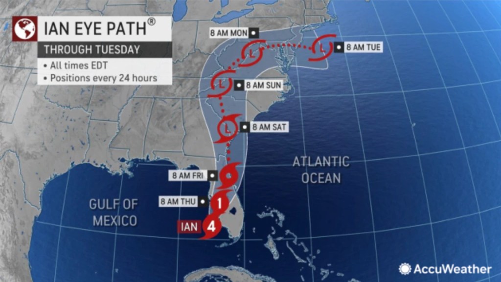
Huracán Ian
El huracán Ian golpeó a Cuba como un huracán fortalecido el 27/09 antes de convertirse en un huracán de Categoría 4 (CAT4) mientras cruzaba el Golfo de México, trayendo ráfagas de viento de más de 150 mph al suroeste de Florida. Ian luego rastreó el océano Atlántico occidental el Jueves 29/09 antes de desviarse hacia el noroeste de regreso a Carolina del Sur. Vientos racheados de más de 50 mph se registraron en partes del centro y sur de los Apalaches el Sábado 01/10 antes de que Ian se debilitara y disipara cerca de la frontera de Carolina del Norte y Virginia esa noche.
La cuarta tormenta más poderosa que azota el territorio continental de Estados Unidos ha matado al menos a 32 personas en Florida y los estados de Carolina en la última semana. El Huracán Ian dejaba el Estado de Florida para darse paso al Estado de Carolina del Sur disminuyendo su intensidad. Los observadores meteorológicos experimentados fueron tomados por sorpresa con la intensidad de del fenómeno meteorológico. ![]()
Post-Hurricane Ian aviation
Airports affected by the hurricane
The devastating impact of Hurricane Ian on the State of Florida and aviation have had consequences of considerable magnitude. The Miami-Fort Lauderdale area has been spared the worst of the weather phenomenon, the sprawling subtropical metropolis has felt its force in the form of intense rain bands stretching nearly 200 miles from the center of the hurricane.
Southeast Florida is a general aviation hub for the United States and the Caribbean. This vital industry was hit hard Tuesday night 9/27 when strong thunderstorm cells spawned tornadoes in the Miami-Dade and Broward County area. Aside from residential impacts, the county was particularly hard hit with a tornado that touched down at North Perry/HWO Airport. North Perry Airport is a public airport in the city of Pembroke Pines, 5 miles west of the central business district of Hollywood, in Broward County, Florida, United States. It is also known as Hollywood North Perry Airport, hence the HWO codes. It is a high-traffic airfield that is usually bustling with flight training activity and banner towing operations. Patchy but substantial damage to facilities and general aviation.
Sarasota/SRQ Airport has been the hardest hit by Hurricane Ian. The tornadoes produced by the rainband were just a hint of what other parts of the State of Florida were about to experience. On Wednesday at 03:05 pm, Hurricane Ian made landfall near Key Costa on the Gulf Coast of southwestern Florida, producing 150 mph winds and a storm surge of more than 7 feet in the communities nearby before reaching land. As a result, initial assessments indicated substantial damage to infrastructure, and airports were once again affected. Sarasota-Bradenton International Airport has reported damage to a section of the roof membrane and many of the terminal’s roof tiles falling off. Rick Piccolo, President and CEO of the airport, has stated that the detached roof membrane section is approximately 100ft X 100ft and the damage to the terminal was contained to a specific area near the Sun Country Airlines check-in counters. He and other members of the operational team spent the night at the airport covering computers and other vital equipment with plastic sheeting before the eyewall arrived. Cleanup efforts are already underway.
Hurricane Ian
Hurricane Ian struck Cuba as a strengthened hurricane on 09/27 before becoming a Category 4 (CAT4) hurricane as it crossed the Gulf of Mexico, bringing wind gusts of over 150 mph to Southwest Florida. Ian then tracked the western Atlantic Ocean on Thursday 09/29 before drifting northwest back to South Carolina. Gusty winds in excess of 50 mph were reported across portions of the central and southern Appalachians on Saturday 10/01 before Ian weakened and dissipated near the North Carolina/Virginia border that evening.
The fourth most powerful storm to hit the continental United States has killed at least 32 people in Florida and the Carolina states in the past week. Hurricane Ian left the State of Florida to make way for the State of South Carolina, decreasing its intensity. Experienced weather watchers were caught off guard by the intensity of the weather phenomenon. ![]()

PUBLISHER: Airgways.com
DBk: Noaa.gov / Accuweather.com / Airgways.com
AW-POST: 202210030927AR
OWNERSHIP: Airgways Inc.
A\W A I R G W A Y S ®
