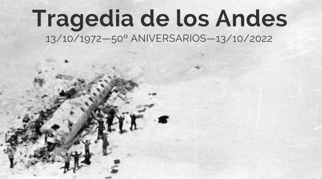
Ξ 50º aniversarios Tragedia Andes Ξ
AW | 2022 10 13 23:58 | AVIATION HISTORY
A medio siglo del accidente que conmocionó al mundo
El vuelo 571 de la Fuerza Aérea Uruguaya, fue un vuelo fletado desde Montevideo, Uruguay, con destino a Santiago, Chile, que se estrelló en la cordillera de los Andes el 13 de Octubre de 1972. El accidente y la posterior supervivencia se conocieron como el Desastre del Vuelo de los Andes, Tragedia de los Andes y el Milagro de los Andes.
Mientras cruzaba los Andes durante el mal tiempo, el inexperto copiloto Lagurara estaba a los mandos del Fairchild FH-227D. Creyó erróneamente que la aeronave había llegado a Curicó, donde el vuelo giraría para descender al Aeropuerto de Pudahuel. No se dio cuenta de que las lecturas de los instrumentos indicaban que todavía estaba a 60-70 km (37-43 millas) de Curicó. Comenzó a descender y el avión golpeó una montaña, cortando ambas alas y la sección de la cola. La porción restante del fuselaje se deslizó por un glaciar a un estimado de 350 km/h (220 mph) y descendió unos 725 metros (2,379 pies) antes de estrellarse contra el hielo y la nieve.
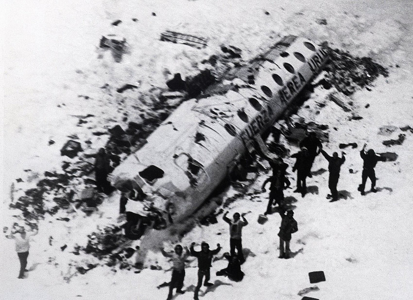
El vuelo transportaba a 45 pasajeros y tripulantes, incluidos 19 miembros del equipo de rugby Old Christians Club, junto con sus familias, simpatizantes y amigos. Tres miembros de la tripulación y nueve pasajeros murieron de inmediato; varios más murieron poco después debido a las gélidas temperaturas y la gravedad de sus heridas. El naufragio fue localizado a una altura de 3.570 metros (11.710 pies) en los remotos Andes del extremo occidental de Argentina, justo al este de la frontera con Chile. Las autoridades sobrevolaron el lugar del accidente varias veces durante los días siguientes, buscando la aeronave, pero no pudieron ver el fuselaje blanco contra la nieve. Los esfuerzos de búsqueda fueron cancelados después de ocho días.
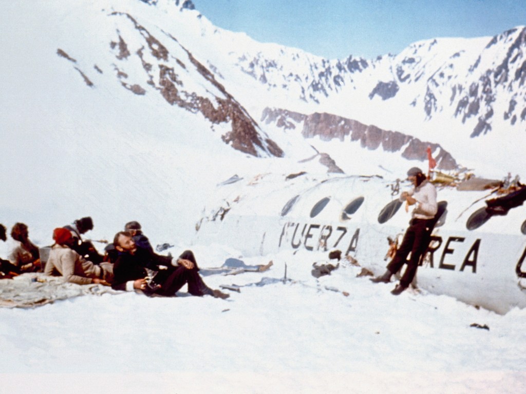
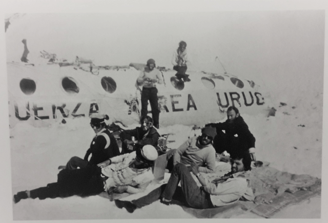
Durante los siguientes 72 días, los sobrevivientes sufrieron dificultades extremas, incluida la exposición, el hambre y una avalancha, lo que provocó la muerte de trece pasajeros más. El resto de pasajeros recurrieron al canibalismo. A medida que el clima mejoró con la llegada de finales de la primavera, dos sobrevivientes, Nando Parrado y Roberto Canessa, escalaron un pico de montaña de 4.650 metros (15.260 pies) sin equipo y caminaron durante 10 días en Chile para buscar ayuda, viajando 61 km (38 millas). El 23 de Diciembre de 1972, dos meses después del accidente, el último de los 16 supervivientes fue rescatado. La noticia de su milagrosa supervivencia atrajo titulares mundiales.
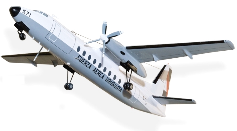
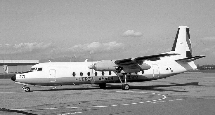
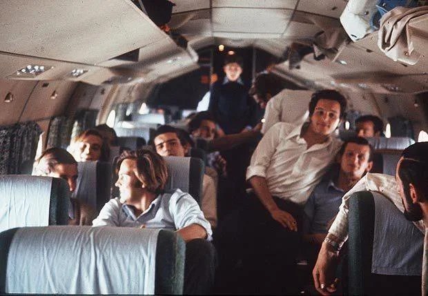
Los miembros del equipo amateur de rugby Old Christians Club de Montevideo, Uruguay, estaban programados para jugar un partido contra el Old Boys Club, un equipo de rugby inglés en Santiago, Chile. El presidente del club, Daniel Juan, fletó un Fairchild FH-227D biturbohélice de la Fuerza Aérea Uruguaya para volar el equipo sobre los Andes hasta Santiago. El avión transportaba a 40 pasajeros y cinco miembros de la tripulación. El Coronel Julio César Ferradas era un experimentado piloto de la Fuerza Aérea que tenía un total de 5.117 horas de vuelo. Lo acompañó el copiloto teniente coronel Dante Héctor Lagurara. Había 10 asientos adicionales y los miembros del equipo invitaron a algunos amigos y familiares a acompañarlos. Cuando alguien canceló en el último minuto, Graziela Mariani compró el asiento para poder asistir a la boda de su hija mayor.
El avión partió del Aeropuerto Internacional de Carrasco el 12 de Octubre de 1972, pero un frente de tormenta sobre los Andes los obligó a detenerse durante la noche en Mendoza, Argentina. Aunque hay una ruta directa de Mendoza a Santiago 200 kilómetros (120 millas) al oeste, las altas montañas requieren una altitud de 25,000 a 26,000 pies (7,600 a 7,900 m), muy cerca del techo operativo máximo del FH-227D de 28,000 pies (8,500 m). Dado que el avión FH-227 estaba completamente cargado, esta ruta habría requerido que el piloto calculara muy cuidadosamente el consumo de combustible y evitara las montañas. En cambio, era costumbre que este tipo de aeronaves volaran una ruta más larga de 600 kilómetros (370 millas) y 90 minutos en forma de «U» desde Mendoza hacia el sur hasta Malargüe utilizando la vía aérea A7 (conocida hoy como UW44). Desde allí, los aviones volaron hacia el oeste a través de la vía aérea G-17 (UB684), cruzando Planchón hasta el radiobacón curicó en Chile, y desde allí hacia el norte hasta Santiago.

El clima del 13 de Octubre de 1972 también afectó el vuelo. En esa mañana las condiciones sobre los Andes no habían mejorado, pero se esperaban cambios a primera hora de la tarde. El piloto esperó y despegó a las 14:18 horas del Viernes 13 de Octubre de 1972 desde Mendoza. Voló hacia el sur desde Mendoza hacia el radiobacon de Malargüe en el nivel de vuelo 180 (FL180, 18,000 pies (5,500 m)). Lagurara llamó por radio al aeropuerto de Malargüe con su posición y les dijo que alcanzarían los 2.515 metros (8.251 pies) de altura del Paso Planchón a las 03:21 p.m. Planchón Pass es el punto de entrega de control de tráfico aéreo de un lado a otro de los Andes, con controladores en Mendoza transfiriendo tareas de seguimiento de vuelos al control de tráfico aéreo de Pudahuel en Santiago, Chile. Una vez que cruzó las montañas en Chile, al sur de Curicó, se suponía que la aeronave debía girar hacia el norte e iniciar un descenso al aeropuerto de Pudahuel en Santiago.
El piloto Ferradas había volado a través de los Andes 29 veces anteriormente. En este vuelo estaba entrenando al copiloto Lagurara, que estaba a los mandos. Mientras volaban a través de los Andes, las nubes oscurecían las montañas. El avión, FAU 571, tenía cuatro años y tenía 792 horas de fuselaje. El avión era considerado por algunos pilotos como de poca potencia, y había sido apodado por ellos como el «trineo de plomo».
Dada la cobertura de nubes, los pilotos volaban bajo condiciones meteorológicas instrumentales a una altitud de 18,000 pies (5,500 m) (FL180), y no pudieron confirmar visualmente su ubicación. Si bien algunos informes indican que el piloto estimó incorrectamente su posición utilizando el cálculo muerto, el piloto confiaba en la navegación por radio. El instrumento VOR/DME de la aeronave mostró al piloto una lectura digital de la distancia a la siguiente radiobaliza en Curicó. En planchón Pass, el avión todavía tenía que viajar 60-70 km (37-43 millas) para llegar a Curicó.
De todos modos, a las 03:21 p.m., poco después de transitar el paso, Lagurara contactó a Santiago y notificó a los controladores aéreos que esperaba llegar a Curicó un minuto después. El tiempo de vuelo desde el paso a Curicó es normalmente de 11 minutos, pero solo tres minutos después el piloto le dijo a Santiago que estaban pasando Curicó y girando hacia el norte. Solicitó permiso al control de tráfico aéreo para descender. El controlador en Santiago, sin saber que el vuelo todavía estaba sobre los Andes, lo autorizó a descender a 11,500 pies (3,500 m) (FL115). Un análisis posterior de su trayectoria de vuelo encontró que el piloto no solo había girado demasiado pronto, sino que había girado en una dirección de 014 grados, cuando debería haber girado a 030 grados.
A medida que el avión descendía, una turbulencia severa arrojó el avión hacia arriba y hacia abajo. Nando Parrado recordó haber golpeado una corriente descendente, lo que provocó que el avión cayera varios cientos de pies y saliera de las nubes. Los jugadores de rugby bromearon sobre la turbulencia al principio, hasta que algunos pasajeros vieron que el avión estaba muy cerca de la montaña. «Ese fue probablemente el momento en que los pilotos vieron la cresta negra elevándose muerta por delante».
Roberto Canessa dijo más tarde que pensó que el piloto giró hacia el norte demasiado pronto, y comenzó el descenso a Santiago mientras la aeronave todavía estaba en lo alto de los Andes. Luego, «comenzó a subir, hasta que el avión estaba casi vertical y comenzó a detenerse y temblar». Sonó la alarma de colisión en tierra de la aeronave, alarmando a todos los pasajeros.
El piloto aplicó la máxima potencia en un intento de ganar altitud. Los relatos de testigos y la evidencia en la escena indicaron que el avión golpeó la montaña dos o tres veces. El piloto pudo llevar la nariz del avión sobre la cresta, pero a las 03:34 p.m., la parte inferior del cono de cola puede haber recortado la cresta a 4.200 metros (13.800 pies). La siguiente colisión cortó la banda derecha. Algunas pruebas indican que fue arrojado hacia atrás con tal fuerza que arrancó el estabilizador vertical y el cono de cola. Cuando el cono de cola se desprendió, se llevó consigo la parte trasera del fuselaje, incluidas dos filas de asientos en la sección trasera de la cabina de pasajeros, la cocina, la bodega de equipaje, el estabilizador vertical y los estabilizadores horizontales, dejando un gran agujero en la parte trasera del fuselaje. Tres pasajeros, el navegante y el mayordomo se perdieron con la sección de cola.
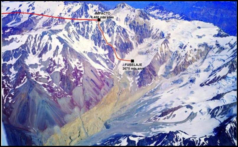
El avión continuó hacia adelante y hacia arriba otros 200 metros (660 pies) durante unos segundos más cuando el ala izquierda golpeó un afloramiento a 4.400 metros (14.400 pies), arrancando el ala. Una de las hélices atravesó el fuselaje cuando el ala a la que estaba unido fue cortada. Dos pasajeros más cayeron de la parte trasera abierta del fuselaje. La parte delantera del fuselaje voló directamente a través del aire antes de deslizarse por el glaciar empinado a 350 km/h (220 mph) como un tobogán de alta velocidad y descendió unos 725 metros (2,379 pies). Cuando el fuselaje chocó con un banco de nieve, los asientos fueron arrancados de su base y arrojados contra el mamparo delantero y entre sí. El impacto aplastó la cabina con los dos pilotos dentro, matando a Ferradas de inmediato.
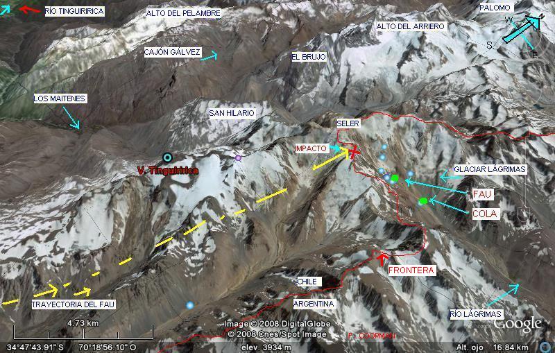
La investigación oficial concluyó que el accidente fue causado por un vuelo controlado en el terreno debido a un error del piloto. El fuselaje del avión se posó en un glaciar en 34°45′54″S 70°17′11″O a una altitud de 3.570 metros (11.710 pies) en el Departamento Malargüe, Provincia de Mendoza. El glaciar sin nombre, más tarde llamado Glaciar de las Lágrimas, se encuentra entre el Monte Sosneado y el Volcán Tinguiririca de 4.280 metros (14.040 pies) de altura, a caballo entre la remota frontera montañosa entre Chile y Argentina. Está al sur de los 4.650 metros (15.260 pies) de altura del Monte Seler. ![]()
Ξ 50th anniversary Tragedy of the Andes Ξ
Half a century after the accident that shocked the world
Flight 571 of the Uruguayan Air Force, was a chartered flight from Montevideo, Uruguay, bound for Santiago, Chile, which crashed in the Andes Mountains on October 13, 1972. The accident and subsequent survival became known as the Disaster of the Flight of the Andes, Tragedy of the Andes and the Miracle of the Andes.
While crossing the Andes during bad weather, inexperienced co-pilot Lagurara was at the controls of the Fairchild FH-227D. He mistakenly believed that the aircraft had arrived in Curicó, where the flight would turn to descend to Pudahuel Airport. He did not realize that the instrument readings indicated that he was still 60-70 km (37-43 miles) from Curicó. He began to descend and the plane hit a mountain, severing both wings and the tail section. The remaining portion of the fuselage slid down a glacier at an estimated 220 mph (350 km/h) and dropped some 2,379 feet (725 meters) before crashing into ice and snow.
The flight was carrying 45 passengers and crew, including 19 members of the Old Christians Club rugby team, along with their families, supporters and friends. Three crew members and nine passengers died immediately; several more died soon after due to the frigid temperatures and the severity of their injuries. The wreck was located at an elevation of 3,570 meters (11,710 feet) in the remote Andes of Argentina’s far west, just east of the Chilean border. Authorities flew over the crash site several times over the next few days, looking for the aircraft, but could not see the white fuselage against the snow. Search efforts were called off after eight days.
Over the next 72 days, the survivors suffered extreme hardship, including exposure, starvation, and an avalanche, resulting in the deaths of a further thirteen passengers. The rest of the passengers resorted to cannibalism. As the weather improved with the arrival of late spring, two survivors, Nando Parrado and Roberto Canessa, scaled a 15,260-foot (4,650-meter) mountain peak without equipment and trekked for 10 days in Chile to seek help, traveling 61 km (38 miles). On December 23, 1972, two months after the accident, the last of the 16 survivors was rescued. The news of his miraculous survival attracted world headlines.
Members of the Old Christians Club amateur rugby team from Montevideo, Uruguay were scheduled to play a match against the Old Boys Club, an English rugby team in Santiago, Chile. Club president Daniel Juan chartered a twin-turboprop Fairchild FH-227D from the Uruguayan Air Force to fly the team over the Andes to Santiago. The aircraft was carrying 40 passengers and five crew members. Colonel Julio César Ferradas was an experienced Air Force pilot who had a total of 5,117 flight hours. He was accompanied by co-pilot Lieutenant Colonel Dante Héctor Lagurara. There were an additional 10 seats and the team members invited some friends and family to join them. When someone canceled at the last minute, Graziela Mariani bought her seat so she could attend her oldest daughter’s wedding.
The plane left Carrasco International Airport on October 12, 1972, but a storm front over the Andes forced them to stop overnight in Mendoza, Argentina. Although there is a direct route from Mendoza to Santiago 200 kilometers (120 mi) to the west, the high mountains require an altitude of 25,000 to 26,000 feet (7,600 to 7,900 m), very close to the FH-227D’s maximum operating ceiling of 28,000 feet (8,500m). Since the FH-227 aircraft was fully loaded, this route would have required the pilot to calculate fuel consumption very carefully and avoid mountains. Instead, it was customary for this type of aircraft to fly a longer route of 600 kilometers (370 miles) and 90 minutes in a «U» shape from Mendoza south to Malargüe using the A7 airway (known today as UW44). From there, the planes flew west via airway G-17 (UB684), across Planchón to radiobacón Curicó in Chile, and from there north to Santiago.
The weather on October 13, 1972 also affected the flight. On that morning the conditions over the Andes had not improved, but changes were expected in the early afternoon. The pilot waited and took off at 14:18 hours on Friday, October 13, 1972 from Mendoza. He flew south from Mendoza toward the Malargüe radiobacon at flight level 180 (FL180, 18,000 feet (5,500 m)). Lagurara radioed the Malargüe airport with his position and told them that they would reach the 2,515-meter (8,251-foot) height of Paso Planchón at 03:21 p.m. Planchón Pass is the air traffic control handover point from one side of the Andes to the other, with controllers in Mendoza transferring flight tracking duties to Pudahuel air traffic control in Santiago, Chile. Once he crossed the mountains in Chile, south of Curicó, the aircraft was supposed to turn north and begin a descent to the Pudahuel airport in Santiago.
Pilot Ferradas had flown across the Andes 29 times previously. On this flight he was training co-pilot Lagurara, who was at the controls. As they flew through the Andes, clouds obscured the mountains. The aircraft, FAU 571, was four years old and had 792 airframe hours. The aircraft was considered by some pilots to be underpowered, and had been nicknamed by them the «lead sled».
Given the cloud cover, the pilots were flying under instrument meteorological conditions at an altitude of 18,000 feet (5,500 m) (FL180), and were unable to visually confirm their location. While some reports indicate that the pilot incorrectly estimated his position using dead reckoning, the pilot relied on radio navigation. The aircraft’s VOR/DME instrument showed the pilot a digital readout of the distance to the next marker on Curico. At Planchón Pass, the plane still had to travel 60-70 km (37-43 miles) to reach Curicó.
In any case, at 03:21 p.m., shortly after transiting the pass, Lagurara contacted Santiago and notified air traffic controllers that he expected to arrive in Curicó a minute later. Flight time from the pass to Curicó is normally 11 minutes, but only three minutes later the pilot told Santiago that they were passing Curicó and turning north. He requested permission from air traffic control to descend. The controller in Santiago, unaware that the flight was still over the Andes, cleared it to descend to 11,500 feet (3,500 m) (FL115). Further analysis of his flight path found that the pilot had not only turned too soon, but had turned in a direction of 014 degrees, when he should have turned at 030 degrees.
As the plane descended, severe turbulence tossed the plane up and down. Nando Parrado recalled hitting a downdraft, causing the plane to drop several hundred feet and out of the clouds. The rugby players joked about the turbulence at first, until some passengers saw that the plane was too close to the mountain. «That was probably the moment the pilots saw the black crest rising dead ahead».
Roberto Canessa later said that he thought the pilot turned north too soon, and began the descent to Santiago while the aircraft was still high in the Andes. He then «began to climb, until the plane was almost vertical and it began to stall and shake». The aircraft’s ground collision alarm sounded, alarming all passengers.
The pilot applied full power in an attempt to gain altitude. Witness accounts and evidence at the scene indicated that the plane hit the mountain two or three times. The pilot was able to bring the nose of the aircraft over the ridge, but by 03:34 p.m. the bottom of the tail cone may have clipped the ridge at 4,200 meters (13,800 ft). The next collision cut the right wing. Some evidence indicates that it was thrown backwards with such force that it tore off the vertical stabilizer and tail cone. When the tail cone detached, it took with it the rear of the fuselage, including two rows of seats in the rear section of the passenger cabin, galley, baggage hold, vertical stabilizer, and horizontal stabilizers, leaving a large hole in the rear of the fuselage. Three passengers, the navigator and the steward were lost with the tail section.
The aircraft continued forward and upward another 200 meters (660 ft) for a few more seconds when the left wing hit an outcrop at 4,400 meters (14,400 ft), ripping the wing off. One of the propellers tore through the fuselage when the wing it was attached to was severed. Two more passengers fell from the open rear of the fuselage. The front part of the fuselage flew straight through the air before sliding down the steep glacier at 220 mph (350 km/h) like a high-speed slide and descending some 2,379 feet (725 meters). When the fuselage struck a snow bank, the seats were ripped off their bases and thrown against the forward bulkhead and each other. The impact crushed the cockpit with both pilots inside, killing Ferradas immediately.
The official investigation concluded that the accident was caused by a controlled flight on the ground due to pilot error. The plane’s fuselage landed on a glacier at 34°45’54″S 70°17’11″W at an altitude of 3,570 meters (11,710 feet) in Malargüe Department, Mendoza Province. The unnamed glacier (later named Glaciar de las Lágrimas or Glacier of Tears) lies between Mount Sosneado and the 4,280-meter (14,040-foot) high Tinguiririca Volcano, straddling the remote mountainous border between Chile and Argentina. It is south of the 4,650-meter (15,260-foot) high Mount Seler. ![]()


PUBLISHER: Airgways.com
DBk: Wikipedia.org / Airgways.com
AW-POST: 202210132358AR
OWNERSHIP: Airgways Inc.
A\W A I R G W A Y S ®