Ciclones sobre el Pacífico Sur
AW | 2021 02 02 18:18 | AVIATION SAFETY / AIR TRAFFIC
Múltiples ciclones se mueven en Oceanía

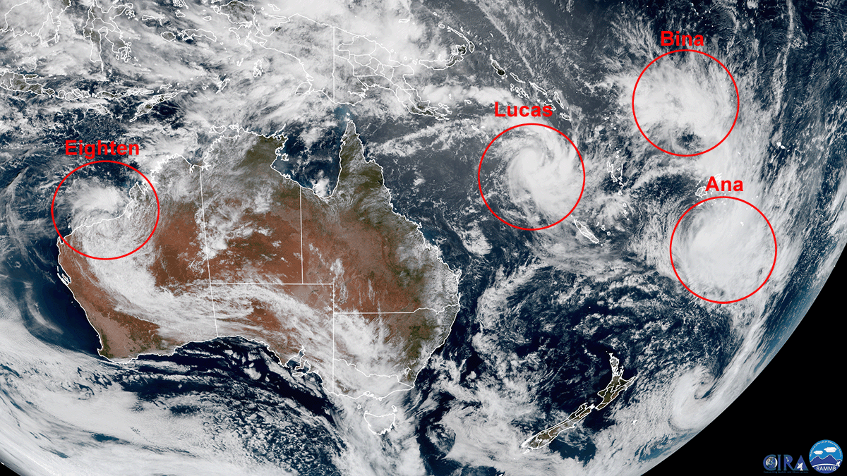
El 1 de Febrero de 2021, el satélite Himawari-8, operado por la Agencia Meteorológica de Japón, ha detectado a tres ciclones que sobrepasaron el Pacífico Sur, y otro empujando a través de Australia Occidental.
El primer y más lejano este es el Ciclón Tropical Ana, situado aproximadamente a 330 millas al sur-sureste de Fiji. Con vientos sostenidos de alrededor de 50 mph, Ana tocó tierra sobre Viti Levu, Fiji, el 30 de Enero 2021 y causó grandes daños a la nación insular. El Ciclón Ana cruzó las principales islas de Fiji el 31/01 y está siguiendo el sureste desde la tierra hasta el sur de Tonga. Se han emitido avisos para Vanuatu y Nueva Caledonia, donde se espera que los vientos se fortalezcan durante el día.
El segundo, Ciclón Tropical Bina, situado al norte-noroeste de Fiji y siguiendo un camino similar al de Ana, también está azotando la región, aunque se ha debilitado desde que se capturaron las imágenes anteriores.
El tercero, el Ciclón Tropical Lucas, está girando sobre el Mar de Salomón, entre las Islas Salomón y Papúa Nueva Guinea. Se dirige hacia Nueva Caledonia, y se prevé que regrese hacia Australia como una tormenta debilitada después. Un cuarto, el Ciclón Tropical Dieciocho, está en el interior de Australia Occidental, y está rastreando a través de la parte noroeste del continente. Se espera que surja sobre el Océano Indico e intensifique, debido a las condiciones favorables. El Ciclón Lucas es un sistema de Categoría 2 que se mueve al suroeste de Vanuatu hacia las Islas de Lealtad de Nueva Caledonia. Se pronostica que el Ciclón Lucas traerá lluvias intensas y alta mar, con los residentes aconsejados para prepararse para la tormenta a golpear. El sistema de Categoría 2 está al norte del territorio y se prevé que se impulse a las islas de Lealtad esta noche. La tormenta lleva vientos de fuerza de tormenta destructiva de 110 km/h a 160 km/h en un radio de 55 kilómetros de su centro. Los eventos programados para hoy se están cancelando y los vuelos nacionales se están adelantando. Se recomienda a los residentes que aseguren su propiedad y se abaten de lo esencial. Se prevé que el sistema de rápido movimiento se destinará hacia el suroeste este 02/02 y cruzará la isla principal cerca de Noumea. Mientras tanto, se prevén fuertes lluvias y fuertes vientos para la vecina Vanuatu con una advertencia de que las inundaciones repentinas de zonas bajas y mares ásperos.
Esta imagen fue capturada por el Advanced Himawari Imager (AHI) en el satélite Himawari-8 de Japón. Este satélite, la primera unidad de la tercera generación de satélites geoestacionarios de la Agencia Meteorológica de Japón (JMA), proporciona imágenes de luz e infrarrojos visibles de la región de Asia y el Pacífico. Los datos de Himawari son vitales para la cobertura geoestacionaria global, razón por la cual la NOAA y JMA han acordado acuerdos de respaldo mutuos para sus sistemas geoestacionarios.![]()
Cyclones over the South Pacific

Multiple cyclones move in Oceania
On February 1, 2021, the Himawari-8 satellite, operated by the Japan Meteorological Agency, detected three cyclones that passed the South Pacific, and another pushing through Western Australia.
The first and farthest east is Tropical Cyclone Ana, located approximately 330 miles south-southeast of Fiji. With sustained winds of around 50 mph, Ana made landfall over Viti Levu, Fiji, on January 30, 2021, causing extensive damage to the island nation. Cyclone Ana crossed the main islands of Fiji on 01/31 and is following southeast from land to southern Tonga. Advisories have been issued for Vanuatu and New Caledonia, where winds are expected to strengthen during the day.
The second, Tropical Cyclone Bina, located north-northwest of Fiji and following a similar path to Ana’s, is also hitting the region, although it has weakened since the previous images were captured.
The third, Tropical Cyclone Lucas, is circling over the Solomon Sea, between the Solomon Islands and Papua New Guinea. It is heading towards New Caledonia, and is expected to return towards Australia as a weakening storm afterwards. A fourth, Tropical Cyclone Eighteen, is in the Western Australian outback, and is tracking across the northwestern part of the continent. It is expected to surge over the Indian Ocean and intensify, due to favorable conditions. Cyclone Lucas is a Category 2 system moving southwest from Vanuatu towards the Loyalty Islands of New Caledonia. Cyclone Lucas is forecast to bring heavy rain and high seas, with residents being advised to prepare for the storm to hit. The Category 2 system is to the north of the territory and is expected to be pushed to the Loyalty Islands tonight. The storm carries destructive storm force winds from 110 km/h to 160 km/h within a radius of 55 kilometers from its center. The events scheduled for today are being canceled and domestic flights are being brought forward. Residents are advised to secure their property and stockpile essentials. The fast-moving system is anticipated to move to the southwest tomorrow, crossing the main island near Noumea. Meanwhile, heavy rain and high winds are forecast for neighboring Vanuatu with a warning of flash flooding from low-lying areas and rough seas.
This image was captured by the Advanced Himawari Imager (AHI) on Japan’s Himawari-8 satellite. This satellite, the first unit of the third generation of geostationary satellites of the Japan Meteorological Agency (JMA), provides visible light and infrared images of the Asia-Pacific region. Himawari data is vital for global geostationary coverage, which is why NOAA and JMA have agreed to mutual support agreements for their geostationary systems.![]()

PUBLISHER: Airgways.com
DBk: Noaa.gov / Airgways.com
AW-POST: 202102021818AR
A\W A I R G W A Y S ®