
A.W. | 2022 01 17 15:35 | AEROSPACE
Estación Espacial Internacional conectada con satélite de Airbus
![]()
La SpaceDataHighway de Airbus, desarrollada con el apoyo de la European Space Agency (ESA), proporciona servicios de conectividad de banda ancha entre la Estación Espacial Internacional (ISS) y la Tierra. Con el terminal de banda Ka de Columbus (ColKa) ahora instalado y completamente probado a bordo de la ISS, un satélite SpaceDataHighway comenzará a transmitir datos a través de un enlace bidireccional en tiempo real entre el Laboratorio Columbus de la ISS y el Centro de control de Columbus ubicado en el Centro Aeroespacial Alemán DLR cerca de Múnich, así como centros de investigación en toda Europa. Beneficiados por SpaceDataHighway y la terminal ColKa, la ESA se beneficiará de un acceso directo y soberano a la ISS, lo que aumentará la flexibilidad operativa y permitirá que más astronautas, científicos e investigadores se beneficien de un enlace directo con Europa. Esto también permitirá a la ESA crear espacios para el acceso a experimentos ad-hoc y la interacción con astronautas europeos.
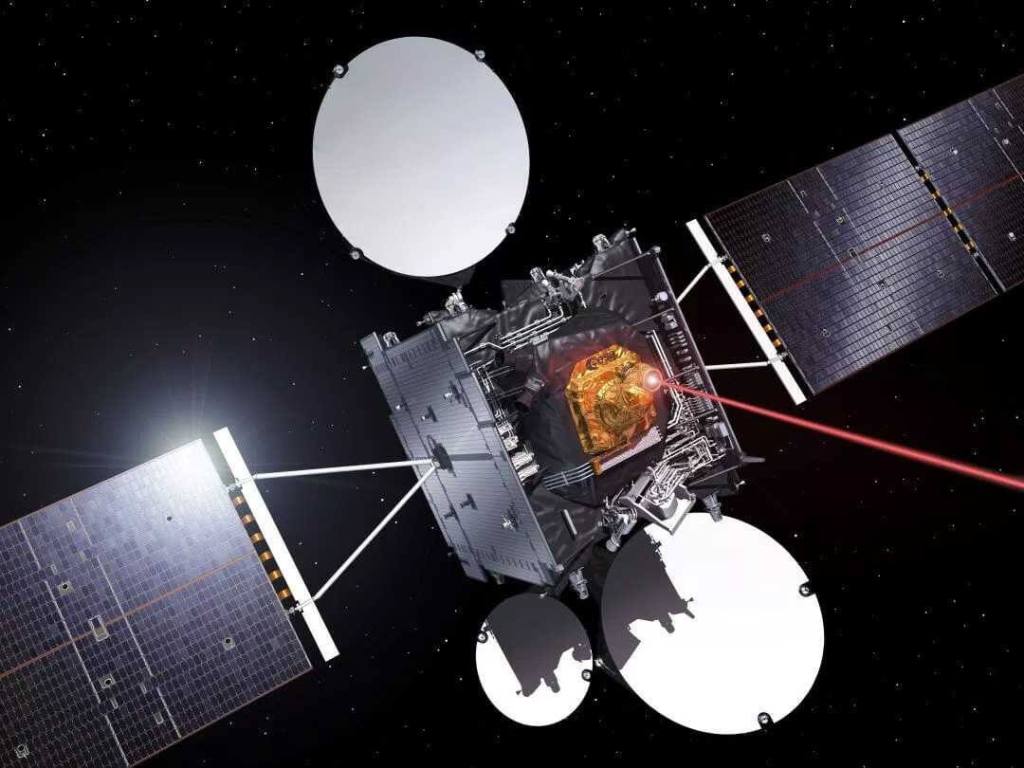
La prestación del servicio de datos ColKa ha sido contratada entre ESA y Airbus. Como parte de este nuevo servicio SpaceDataHighway, Airbus ha adaptado su enlace entre satélites en banda Ka para garantizar que los datos se canalicen a través de la estación terrestre en Harwell Campus, Reino Unido. Además de este servicio de banda Ka, SpaceDataHighway es la primera constelación geoestacionaria de comunicaciones por láser del mundo. Representa un cambio de juego en la velocidad de las comunicaciones espaciales, utilizando tecnología láser de vanguardia para brindar servicios de transferencia de datos seguros casi en tiempo real. El sistema ha logrado más de 50 000 conexiones láser exitosas en los primeros cinco años de operaciones de rutina. Sus satélites pueden conectarse a la ISS, así como a satélites de observación en órbita baja a una distancia de hasta 45.000 km. Desde su posición en órbita geoestacionaria, el sistema SpaceDataHighway transmite casi en tiempo real a la Tierra los datos recopilados, un proceso que normalmente llevaría varias horas. Por tanto, permite aumentar considerablemente la cantidad de datos de imagen y vídeo transmitidos por los satélites de observación y reprogramar su plan de misión en cualquier momento y en tan solo unos minutos.
Con su SpaceDataHighway, Airbus ya presta servicio diariamente a cuatro satélites Copernicus Sentinel y continúa ampliando sus servicios a más clientes. Pleiades Neo, la constelación óptica de observación de la Tierra más avanzada de Airbus con cuatro satélites de resolución de 30 cm, son los próximos satélites que se beneficiarán de la infraestructura de SpaceDataHighway y optimizarán aún más la reactividad de la misión proporcionando capacidades de entrega de datos y tareas reactivas casi en tiempo real. ![]()
ISS connected to SpaceDataHighway
International Space Station connected with Airbus satellite
The Airbus SpaceDataHighway, developed with the support of the European Space Agency (ESA), provides broadband connectivity services between the International Space Station (ISS) and Earth. With the Columbus Ka-Band Terminal (ColKa) now installed and fully tested on board the ISS, a SpaceDataHighway satellite will begin transmitting data over a real-time bidirectional link between the ISS Columbus Laboratory and the Control Center. of Columbus located at the DLR German Aerospace Center near Munich, as well as research centers throughout Europe. Benefiting from the SpaceDataHighway and the ColKa terminal, ESA will benefit from direct and sovereign access to the ISS, increasing operational flexibility and allowing more astronauts, scientists and researchers to benefit from a direct link to Europe. This will also allow ESA to create spaces for access to ad-hoc experiments and interaction with European astronauts.
The provision of the ColKa data service has been contracted between ESA and Airbus. As part of this new SpaceDataHighway service, Airbus has adapted its Ka-band inter-satellite link to ensure data is channeled through the ground station at Harwell Campus, UK. In addition to this Ka-band service, SpaceDataHighway is the world’s first geostationary laser communications constellation. It represents a game changer in the speed of space communications, using cutting-edge laser technology to deliver secure data transfer services in near real time. The system has achieved more than 50,000 successful laser connections in the first five years of routine operations. Its satellites can connect to the ISS as well as low-orbiting observation satellites at a distance of up to 45,000 km. From its position in geostationary orbit, the SpaceDataHighway system transmits collected data to Earth in near real time, a process that would normally take several hours. Therefore, it allows you to considerably increase the amount of image and video data transmitted by observation satellites and reprogram your mission plan at any time and in just a few minutes.
With its SpaceDataHighway, Airbus already serves four Copernicus Sentinel satellites daily and continues to expand its services to more customers. Pleiades Neo, Airbus’ most advanced optical Earth observation constellation with four 30 cm resolution satellites, are the next satellites to benefit from the SpaceDataHighway infrastructure and further optimize mission reactivity by providing data delivery capabilities. data and reactive tasks in near real time. ![]()

PUBLISHER: Airgways.com
DBk: Airbus.com / Esa.int
AW-POST: 202201171535AR
OWNERSHIP: Airways Inc.
A\W A I R G W A Y S ®
